
Lake Walchen Power Plant
Encyclopedia
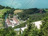
The Walchensee Power Plant is a high pressure storage power station in Bavaria. With an installed output of 124 MW it is today one the largest of its kind in Germany. It is located near Kochel
(distance the town of Walchensee about 14 km).
, serving as an "upper reservoir" (802 m ü. NN), and the "lower reservoir" of Kochelsee
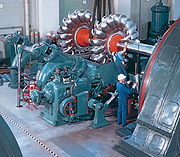
(599 m ü. NN) to generate electricity. Through six 450 meters (approx.) long pipes, which connect the two natural "basins", the water flows to the turbines of this hydro-electric power plant: four Pelton
and four Francis water turbines. Subsequently, it is directed into Lake Kochel. Due to the strongly varying water levels, neither lake properly freezes in the winter. The ice in each of the bays is only very thin and may not be walked upon. The natural outflow of Lake Walchen at Niedernach - over the Jachen to the Isar - is blocked by a weir, yet the natural inflow to the lake is not sufficient to provide enough water for the operation of the storage power station. Therefore the water of the Isar and Rißbach is used.
Therefore the enterprise is forced during the winter to stay informed about the snow situation in the area of water collection, so as to be able to calculate the amount of meltwater will presumably be available, in order to be able to comply with the above-mentioned requirement.
's planned A10 rocket, a new Mach 10 wind tunnel was planned at the power station. The new powerplant was to specially-use the 202 meter difference from the Walchensee down to the Kochelsee
to generate 120 megawatts. However, instead of the new wind tunnel and powerplant, the Mach 4.4 wind tunnel used for V-2 rocket
development was moved to the site following the 1943 Operation Hydra
bombing of Peenemünde
, and the new powerplant was completed after the war. The wind tunnel was moved to White Oak, Maryland
, after the war.
Kochel
Kochel am See is a municipality in the district of Bad Tolz-Wolfratshausen in Bavaria on the shores of Kochelsee.Apart from the idyllic scenery, it is known for The Smith of Kochel "Schmied von Kochel," who according to legend, lead a Bavarian farmer rebellion against Austro-Hungarian occupiers at...
(distance the town of Walchensee about 14 km).
Technical operation
The storage power station uses the natural downward gradient of about 200 m between WalchenseeWalchensee
Walchensee or Lake Walchen is one of the deepest and largest alpine lakes in Germany, with a maximum depth of and an area of . The lake is south of Munich in the middle of the Bavarian Alps. The entire lake, including the island Sassau is part of the municipality of Kochel...
, serving as an "upper reservoir" (802 m ü. NN), and the "lower reservoir" of Kochelsee
Kochelsee
Kochelsee or Lake Kochel is located south of Munich on the edge of the Bavarian Alps. The western third of the lake lies within the borders of the town of Schlehdorf, while the rest belongs to Kochel am See. The southern edge of the lake lies up against the mountains and the northern shore is...
(599 m ü. NN) to generate electricity. Through six 450 meters (approx.) long pipes, which connect the two natural "basins", the water flows to the turbines of this hydro-electric power plant: four Pelton
Pelton wheel
The Pelton wheel is an impulse turbine which is among the most efficient types of water turbines. It was invented by Lester Allan Pelton in the 1870s. The Pelton wheel extracts energy from the impulse of moving water, as opposed to its weight like traditional overshot water wheel...
and four Francis water turbines. Subsequently, it is directed into Lake Kochel. Due to the strongly varying water levels, neither lake properly freezes in the winter. The ice in each of the bays is only very thin and may not be walked upon. The natural outflow of Lake Walchen at Niedernach - over the Jachen to the Isar - is blocked by a weir, yet the natural inflow to the lake is not sufficient to provide enough water for the operation of the storage power station. Therefore the water of the Isar and Rißbach is used.
Isar transfer
The Isar, which flow as a whitewater river from the Austrian part of the Karwendel mountains, is dammed between Mittenwald and Krün at river-kilometer 251.5 by a weir, there forms the Kruener Isar reservoir (870m) and is nearly completely directed to Lake Walchen. This Isarwasser flows first after passing the run hydro-electric power plant Kruen in an open channel, crosses before barrier gau by means of a Duekers the federal highway 11 and with barrier gau by a tunnel the thing lake (867m) is then supplied. Here a 3.9 kilometer of long penstocks begins, at whose end the water propels the turbines of the run hydro-electric power plant upperoh (795m) and finally into the lake flows. At the thing lake surplus water becomes - because the quantity the need exceeds in upperoh or one does not need at all - aboveground derived. It falls down after leaving the memory over a steep stage (the so-called Isarfall), flows then in the upper oh channel to the north and flows finally with Einsiedl into the Walchensee. On the way there the laboratory for hydraulic engineering and water management DO Munich happened.Rissbach transfer
The Rissbach comes from the northern part of the Karwendelgebirges, where it collected the water of the smaller brooks within the range of the maple soils. After exceeding the border between Tirol and Bavaria and immediately after the inlet of the Fermersbaches is accumulated the water-rich brook with the Oswaldhuette at the road front tear (Bavaria) - Hinterriss (Tirol) (830m). Here a lug begins with 6960m length, which with front tear with a Dueker under the flussbett of the Isar and the private road (chargeable), running beside it, and at the run hydro-electric power plant Niedernach at the southeast end of the Walchensees is passed through finally ends. The power station is since 1951 in enterprise.Distinctive features
The main road from the town of Walchensee to Urfeld runs along the steep rock slope of the north bank from Herzogstand. This construction requires the counter-pressure which the water of Lake Walchen exerts on the bank, so that the road does not slide away. If the water level in winter sinks due to outflow through the Lake Walchen power station, the use of the road must be limited by a weight restriction trucks. At a certain time in the spring E.ON is, on pain of penalties, obliged to increase the water level again in such a way that restrictions of traffic - primarily because of tourism - can be lifted.Therefore the enterprise is forced during the winter to stay informed about the snow situation in the area of water collection, so as to be able to calculate the amount of meltwater will presumably be available, in order to be able to comply with the above-mentioned requirement.
History
Oskar of Miller was the Vordenker and planner for the building of the Walchenseekraftwerks. It wanted the electrification the Bavarian course (see also center forest course) and the country Bavaria to in front bring. After long preliminary work the Bavarian federal state parliament 1918 decided the power plant construction, and already 1924 began the first enterprise under the auspice of national Bayernwerk. After Bayernwerk was denationalized and taken over of the VIAG, the old power station is operated by the energy enterprise E.ON water power. The Walchenseekraftwerk produces traction current since its start-up also. The produced total output divides on in 72 MW three-phase alternating current and 52 MW traction current.World War II wind tunnel
For developing Nazi GermanyNazi Germany
Nazi Germany , also known as the Third Reich , but officially called German Reich from 1933 to 1943 and Greater German Reich from 26 June 1943 onward, is the name commonly used to refer to the state of Germany from 1933 to 1945, when it was a totalitarian dictatorship ruled by...
's planned A10 rocket, a new Mach 10 wind tunnel was planned at the power station. The new powerplant was to specially-use the 202 meter difference from the Walchensee down to the Kochelsee
Jochberg (mountain)
Jochberg is a tall mountain in the Bavarian Alpenvorland, the first range of mountains of the Alps in southern Germany. The mountain stands between two large lakes, namely Kochelsee and Walchensee....
to generate 120 megawatts. However, instead of the new wind tunnel and powerplant, the Mach 4.4 wind tunnel used for V-2 rocket
V-2 rocket
The V-2 rocket , technical name Aggregat-4 , was a ballistic missile that was developed at the beginning of the Second World War in Germany, specifically targeted at London and later Antwerp. The liquid-propellant rocket was the world's first long-range combat-ballistic missile and first known...
development was moved to the site following the 1943 Operation Hydra
Bombing of Peenemünde in World War II
Operation Hydra was a Royal Air Force attack on the Peenemünde Army Research Center on the night of 17/18 August 1943. It began the Operation Crossbow strategic bombing campaign against Nazi Germany's V-weapon programme...
bombing of Peenemünde
Peenemünde
The Peenemünde Army Research Center was founded in 1937 as one of five military proving grounds under the Army Weapons Office ....
, and the new powerplant was completed after the war. The wind tunnel was moved to White Oak, Maryland
White Oak, Maryland
White Oak is a census-designated place and an unincorporated area in Montgomery County, Maryland, United States.-Geography:As an unincorporated area, White Oak's boundaries are not officially defined...
, after the war.