

Lake Tahoe-Nevada State Park
Encyclopedia
Lake Tahoe – Nevada State Park is a state park
of Nevada
, USA, on the northeast shores of Lake Tahoe
. The park comprises six management units which total 14301 acres (5,787.4 ha). The park is in the Western Nevada Region of Nevada State Parks. It includes the Marlette Lake Water System
which is listed on the National Register of Historic Places
and as a Historic Civil Engineering Landmark.
. Bouldering, picnicking, the Sand Point nature trail, a boat launch and the Lake Tahoe–Nevada State Park visitor center
are all located here.
and Nevada State Route 28
at "Spooner Summit". Spooner Lake is popular for fishing, and viewing wildlife and wildflowers. The site is also the primary starting point for the Marlette/Hobart Backcountry trails as well as the main vehicle entrance to both areas.
. Marlette Lake and the Hobart Reservoir are popular destinations. These lakes were created to feed the Marlette Lake Water System
during the earlier mining and logging industry of the area. Remnants of abandoned mills can still be seen in areas of the park. No vehicle access is permitted in the backcountry. Pedestrian access is gained through the Spooner Lake trail head, the Tahoe Rim Trail, and various other trails starting in Carson City and Incline Village. Two rustic cabins and several backpacking campsites provide overnight amenities.
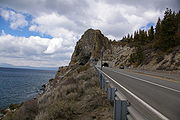 Cave Rock is a small day-use area along U.S. 50. The site features a boat launch, picnic areas and a small sandy beach. The site is located beneath Cave Rock and the Cave Rock Tunnel
.
State park
State parks are parks or other protected areas managed at the federated state level within those nations which use "state" as a political subdivision. State parks are typically established by a state to preserve a location on account of its natural beauty, historic interest, or recreational...
of Nevada
Nevada
Nevada is a state in the western, mountain west, and southwestern regions of the United States. With an area of and a population of about 2.7 million, it is the 7th-largest and 35th-most populous state. Over two-thirds of Nevada's people live in the Las Vegas metropolitan area, which contains its...
, USA, on the northeast shores of Lake Tahoe
Lake Tahoe
Lake Tahoe is a large freshwater lake in the Sierra Nevada of the United States. At a surface elevation of , it is located along the border between California and Nevada, west of Carson City. Lake Tahoe is the largest alpine lake in North America. Its depth is , making it the USA's second-deepest...
. The park comprises six management units which total 14301 acres (5,787.4 ha). The park is in the Western Nevada Region of Nevada State Parks. It includes the Marlette Lake Water System
Marlette Lake Water System
The Marlette Lake Water System was created to provide water for the silver mining boom in Virginia City, Nevada. These structures are now listed as a Historic Civil Engineering Landmark by the American Society of Civil Engineers, and are also listed on the National Register of Historic Places.The...
which is listed on the National Register of Historic Places
National Register of Historic Places
The National Register of Historic Places is the United States government's official list of districts, sites, buildings, structures, and objects deemed worthy of preservation...
and as a Historic Civil Engineering Landmark.
Sand Harbor
Sand Harbor features a large sandy beach on Lake Tahoe's eastern shore. It is also the location of the outdoor Lake Tahoe Shakespeare FestivalLake Tahoe Shakespeare Festival
The Lake Tahoe Shakespeare Festival brings the bard to life on the shores of Lake Tahoe.Performing a series of Shakespeare classics and introducing more contemporary works, audience members take their seats on the beach overlooking the lake to enjoy a picnic dinner before the start of the show.-...
. Bouldering, picnicking, the Sand Point nature trail, a boat launch and the Lake Tahoe–Nevada State Park visitor center
Visitor center
A visitor center or centre , visitor information center, tourist information center, is a physical location that provides tourist information to the visitors who tour the place or area locally...
are all located here.
Spooner Lake
Spooner Lake is located near the intersection of U.S. Route 50U.S. Route 50
U.S. Route 50 is a major east–west route of the U.S. Highway system, stretching just over from Ocean City, Maryland on the Atlantic Ocean to West Sacramento, California. Until 1972, when it was replaced by Interstate Highways west of the Sacramento area, it extended to San Francisco, near...
and Nevada State Route 28
Nevada State Route 28
State Route 28 is a road that runs along the northeastern shore of Lake Tahoe. The road has been designated as the north piece of the Lake Tahoe–Eastshore Drive Scenic Byway as part of the National Scenic Byway program...
at "Spooner Summit". Spooner Lake is popular for fishing, and viewing wildlife and wildflowers. The site is also the primary starting point for the Marlette/Hobart Backcountry trails as well as the main vehicle entrance to both areas.
Marlette/Hobart Backcountry
Miles of hiking and biking trails cover the Marlette/Hobart Backcountry's 13000 acres (52.6 km²) in the Carson Range. Among the most popular trails is the Flume Trail, which offers spectacular views of Lake Tahoe. The area also features a portion of the Tahoe Rim TrailTahoe Rim Trail
The Tahoe Rim Trail is a 165-mile long-distance hiking trail which forms a loop around Lake Tahoe in the Sierra Nevada and Carson ranges of California and Nevada in the United States. The trail ranges in elevation from 6,240 feet at the outlet of Lake Tahoe to 10,338 feet at Relay Peak in Nevada...
. Marlette Lake and the Hobart Reservoir are popular destinations. These lakes were created to feed the Marlette Lake Water System
Marlette Lake Water System
The Marlette Lake Water System was created to provide water for the silver mining boom in Virginia City, Nevada. These structures are now listed as a Historic Civil Engineering Landmark by the American Society of Civil Engineers, and are also listed on the National Register of Historic Places.The...
during the earlier mining and logging industry of the area. Remnants of abandoned mills can still be seen in areas of the park. No vehicle access is permitted in the backcountry. Pedestrian access is gained through the Spooner Lake trail head, the Tahoe Rim Trail, and various other trails starting in Carson City and Incline Village. Two rustic cabins and several backpacking campsites provide overnight amenities.
Cave Rock
Cave Rock Tunnel
The Cave Rock Tunnel is a dual bore highway tunnel on U.S. Route 50 along the eastern shore of Lake Tahoe approximately seven miles north of Stateline, in Douglas County, Nevada, USA...
.