
Lake Shafer
Encyclopedia
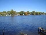
Lake Shafer is one of two reservoirs located in the Twin Lakes area of Monticello, Indiana
. It was created along with Lake Freeman
in the 1920s when two dams were built outside of Monticello on the Tippecanoe River
. It remains a popular recreational area and helps generate an estimated $70 million in tourism revenue for White County
.
30.2 above the confluence
of the Wabash River
. Construction of the dam finished in June, 1923, and it remains standing approximately one mile north of Monticello.
Lake Shafer remains the more commercial of the Twin Lakes, largely due to the presence of the Indiana Beach
Amusement Park and Camp Resort. There are also a vast number of rental cottages and homes as well as boat rental marinas. Many of Lake Shafer's residents are part-timers, spending the majority of their time at the lake on weekends, traditionally April through October. The lake is often busy with boat traffic on summer weekends due to the increase in tourists.
, it is a natural sediment trap. These feeding sediments have caused some parts of the northern part of the lake to be shallowed to as low as 4 feet. Since 2004, there have been active efforts on the lake to dredge many parts of the shallow areas on the lake to remove debris from the bottom of the lake, remove sandbars, and increase the lake's depth.
Since formed, Lake Shafer has been drained in 1965, 1975, 1985, and 1995, so repair work could be made to the Norway Dam..
It was announced that in late April 2008, Lake Shafer will be drained once again for repairs to the Norway Dam. It will be drained 3 feet the weekend of April 26-27, and six feet by May 3-4. Only the main riverbed will remain during the draining of it.
Monticello, Indiana
Monticello is a city in White County, Indiana, United States. The population was 5,378 at the 2010 census. The city is the county seat of White County....
. It was created along with Lake Freeman
Lake Freeman
Lake Freeman is a reservoir outside of Monticello, Indiana formed in 1925 by the completion of the Oakdale Dam. Construction of the Oakdale Dam began in 1923 and was completed in 1925, damming the waters of the Tippecanoe River....
in the 1920s when two dams were built outside of Monticello on the Tippecanoe River
Tippecanoe River
The Tippecanoe River is a gentle, river in northern Indiana that flows from Big Lake in Noble County to the Wabash River near Battle Ground, about northeast of Lafayette. The name "Tippecanoe" comes from a Miami-Illinois word for buffalo fish, reconstructed as */kiteepihkwana/.The Tippecanoe...
. It remains a popular recreational area and helps generate an estimated $70 million in tourism revenue for White County
White County, Indiana
As of the census of 2000, there were 25,267 people, 9,727 households, and 7,090 families residing in the county. The population density was 50 people per square mile . There were 12,083 housing units at an average density of 24 per square mile...
.
History
Creation of Lake Shafer began in 1922 with the construction of the Norway Dam at river mileRiver mile
In the United States, a River mile is a measure of distance in miles along a river from its mouth. River mile numbers begin at zero and increase further upstream. The corresponding metric unit using kilometers is the River kilometer...
30.2 above the confluence
Confluence (geography)
In geography, a confluence is the meeting of two or more bodies of water. It usually refers to the point where two streams flow together, merging into a single stream...
of the Wabash River
Wabash River
The Wabash River is a river in the Midwestern United States that flows southwest from northwest Ohio near Fort Recovery across northern Indiana to southern Illinois, where it forms the Illinois-Indiana border before draining into the Ohio River, of which it is the largest northern tributary...
. Construction of the dam finished in June, 1923, and it remains standing approximately one mile north of Monticello.
Lake Shafer remains the more commercial of the Twin Lakes, largely due to the presence of the Indiana Beach
Indiana Beach
Indiana Beach is an amusement park and resort located on Lake Shafer in Monticello, Indiana.-History:The resort was developed and owned by the Spackman family, who sold to Morgan RV Resorts LLC in 2008...
Amusement Park and Camp Resort. There are also a vast number of rental cottages and homes as well as boat rental marinas. Many of Lake Shafer's residents are part-timers, spending the majority of their time at the lake on weekends, traditionally April through October. The lake is often busy with boat traffic on summer weekends due to the increase in tourists.
Ecology
Because it is located in the Tippecanoe River drainage basinDrainage basin
A drainage basin is an extent or an area of land where surface water from rain and melting snow or ice converges to a single point, usually the exit of the basin, where the waters join another waterbody, such as a river, lake, reservoir, estuary, wetland, sea, or ocean...
, it is a natural sediment trap. These feeding sediments have caused some parts of the northern part of the lake to be shallowed to as low as 4 feet. Since 2004, there have been active efforts on the lake to dredge many parts of the shallow areas on the lake to remove debris from the bottom of the lake, remove sandbars, and increase the lake's depth.
Since formed, Lake Shafer has been drained in 1965, 1975, 1985, and 1995, so repair work could be made to the Norway Dam..
It was announced that in late April 2008, Lake Shafer will be drained once again for repairs to the Norway Dam. It will be drained 3 feet the weekend of April 26-27, and six feet by May 3-4. Only the main riverbed will remain during the draining of it.