

LaGrange, Indiana
Encyclopedia
LaGrange is a town in LaGrange County
, Indiana
, United States
. The population was 2,625 at the 2010 census. The city is the county seat
of LaGrange County
.
.
According to the United States Census Bureau
, the town has a total area of 1.7 square miles (4.4 km²), all of it land.
of 2000, there were 2,919 people, 1,149 households, and 716 families residing in the town. The population density
was 1,717.8 people per square mile (663.0/km²). There were 1,231 housing units at an average density of 724.4 per square mile (279.6/km²). The racial makeup of the town was 93.32% White, 0.38% African American, 0.03% Native American, 0.48% Asian, 4.69% from other races
, and 1.10% from two or more races. Hispanic or Latino of any race were 6.89% of the population.
There were 1,149 households out of which 32.6% had children under the age of 18 living with them, 46.0% were married couples
living together, 12.6% had a female householder with no husband present, and 37.6% were non-families. 32.6% of all households were made up of individuals and 15.2% had someone living alone who was 65 years of age or older. The average household size was 2.42 and the average family size was 3.08.
In the town the population was spread out with 26.6% under the age of 18, 10.0% from 18 to 24, 27.2% from 25 to 44, 19.6% from 45 to 64, and 16.6% who were 65 years of age or older. The median age was 35 years. For every 100 females there were 92.9 males. For every 100 females age 18 and over, there were 82.6 males.
 The median income for a household in the town was $32,054, and the median income for a family was $39,038. Males had a median income of $29,545 versus $21,946 for females. The per capita income
for the town was $17,865. About 4.7% of families and 7.1% of the population were below the poverty line, including 5.7% of those under age 18 and 9.7% of those age 65 or over.
, of Fort Wayne, Indiana
. The courthouse was listed on the National Register of Historic Places
on July 17, 1980.
. It is seven miles away from the Howe-Lagrange interchange of the Indiana Toll Road
. It has no scheduled airline or passenger rail service.
Lagrange is within the South Bend-Elkhart (Indiana) television market.
LaGrange County, Indiana
LaGrange County is a county located in the U.S. state of Indiana and in the Northern Indiana region known as Michiana. As of 2010, the population was 37,128. The county is located about east of South Bend, west of Toledo, Ohio, and northeast of Indianapolis. The area is well known for its large...
, Indiana
Indiana
Indiana is a US state, admitted to the United States as the 19th on December 11, 1816. It is located in the Midwestern United States and Great Lakes Region. With 6,483,802 residents, the state is ranked 15th in population and 16th in population density. Indiana is ranked 38th in land area and is...
, United States
United States
The United States of America is a federal constitutional republic comprising fifty states and a federal district...
. The population was 2,625 at the 2010 census. The city is the county seat
County seat
A county seat is an administrative center, or seat of government, for a county or civil parish. The term is primarily used in the United States....
of LaGrange County
LaGrange County, Indiana
LaGrange County is a county located in the U.S. state of Indiana and in the Northern Indiana region known as Michiana. As of 2010, the population was 37,128. The county is located about east of South Bend, west of Toledo, Ohio, and northeast of Indianapolis. The area is well known for its large...
.
Geography
LaGrange is located at 41°38′37"N 85°25′2"W. It is approximately 11 miles east of Shipshewana, IndianaShipshewana, Indiana
Shipshewana is a town in Newbury Township, LaGrange County, Indiana, United States. The population was 658 at the 2010 census. It is the location of the Menno-Hof Amish & Mennonite Museum, which showcases the history of the Amish and Mennonite peoples....
.
According to the United States Census Bureau
United States Census Bureau
The United States Census Bureau is the government agency that is responsible for the United States Census. It also gathers other national demographic and economic data...
, the town has a total area of 1.7 square miles (4.4 km²), all of it land.
Demographics
As of the censusCensus
A census is the procedure of systematically acquiring and recording information about the members of a given population. It is a regularly occurring and official count of a particular population. The term is used mostly in connection with national population and housing censuses; other common...
of 2000, there were 2,919 people, 1,149 households, and 716 families residing in the town. The population density
Population density
Population density is a measurement of population per unit area or unit volume. It is frequently applied to living organisms, and particularly to humans...
was 1,717.8 people per square mile (663.0/km²). There were 1,231 housing units at an average density of 724.4 per square mile (279.6/km²). The racial makeup of the town was 93.32% White, 0.38% African American, 0.03% Native American, 0.48% Asian, 4.69% from other races
Race (United States Census)
Race and ethnicity in the United States Census, as defined by the Federal Office of Management and Budget and the United States Census Bureau, are self-identification data items in which residents choose the race or races with which they most closely identify, and indicate whether or not they are...
, and 1.10% from two or more races. Hispanic or Latino of any race were 6.89% of the population.
There were 1,149 households out of which 32.6% had children under the age of 18 living with them, 46.0% were married couples
Marriage
Marriage is a social union or legal contract between people that creates kinship. It is an institution in which interpersonal relationships, usually intimate and sexual, are acknowledged in a variety of ways, depending on the culture or subculture in which it is found...
living together, 12.6% had a female householder with no husband present, and 37.6% were non-families. 32.6% of all households were made up of individuals and 15.2% had someone living alone who was 65 years of age or older. The average household size was 2.42 and the average family size was 3.08.
In the town the population was spread out with 26.6% under the age of 18, 10.0% from 18 to 24, 27.2% from 25 to 44, 19.6% from 45 to 64, and 16.6% who were 65 years of age or older. The median age was 35 years. For every 100 females there were 92.9 males. For every 100 females age 18 and over, there were 82.6 males.
Per capita income
Per capita income or income per person is a measure of mean income within an economic aggregate, such as a country or city. It is calculated by taking a measure of all sources of income in the aggregate and dividing it by the total population...
for the town was $17,865. About 4.7% of families and 7.1% of the population were below the poverty line, including 5.7% of those under age 18 and 9.7% of those age 65 or over.
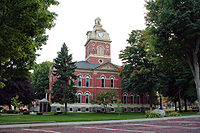
Court House
The Lagrange County Courthouse was designed in 1878 by Thomas J. Tolan, & Son, ArchitectsBrentwood S. Tolan
Brentwood S. Tolan was an American architect.Born in Delphos, Ohio to Thomas J. and Harriet Skinner Tolan. With little formal art training, he apprenticed under his father, a marble craftsman-turned architect, starting in 1872 at age 17...
, of Fort Wayne, Indiana
Fort Wayne, Indiana
Fort Wayne is a city in the US state of Indiana and the county seat of Allen County. The population was 253,691 at the 2010 Census making it the 74th largest city in the United States and the second largest in Indiana...
. The courthouse was listed on the National Register of Historic Places
National Register of Historic Places
The National Register of Historic Places is the United States government's official list of districts, sites, buildings, structures, and objects deemed worthy of preservation...
on July 17, 1980.
Education
The town of LaGrange lies in the school district of Lakeland School Corporation. The local schools town residents attend are:- Parkside Elementary
- Lakeland Middle School
- Lakeland High School
Transportation and Communications
Lagrange has only two numbered state or federal highways: U.S. Highway 20 and Indiana State Road 9Indiana State Road 9
State Road 9 in the U.S. State of Indiana is a long north–south state highway in the eastern portion of Indiana. Its southern terminus is near Columbus at State Road 46, and the northern terminus is at the Michigan/Indiana border between Howe, Indiana, and Sturgis, Michigan, where it...
. It is seven miles away from the Howe-Lagrange interchange of the Indiana Toll Road
Indiana Toll Road
The Indiana Toll Road, officially the Indiana East–West Toll Road, is a toll road that runs for east–west across northern Indiana from the Illinois state line to the Ohio state line...
. It has no scheduled airline or passenger rail service.
Lagrange is within the South Bend-Elkhart (Indiana) television market.