
Kumakogen, Ehime
Encyclopedia
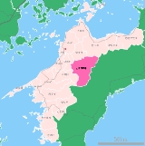
is a town
located in Kamiukena District
, Ehime
, Japan
. The town was formed on August 1, 2004 from the merger of the town of Kuma
, and the villages of Mikawa
, Omogo
and Yanadani
, all from Kamiukena District
.
As of March 1, 2008, the town has an estimated population
of 10,306 and a density
of 17.7 persons per km². The total area is 583.66 km².
, the tallest mountain in Shikoku
at 1982 m is located on the border between Seiyo
to the northeast. Because the town is very mountainous, settlements are located along the Omogo River (Niyodo River). The climate is cool and wet in the summer and winters cold with snow.
Towns of Japan
A town is a local administrative unit in Japan. It is a local public body along with prefecture , city , and village...
located in Kamiukena District
Kamiukena District, Ehime
The is a district located in Ehime Prefecture, Japan. As of 2004 — The estimated population is 11,222 with a total area of 583.66 km².It consists of one town.*Kumakōgen-History:...
, Ehime
Ehime Prefecture
is a prefecture in northwestern Shikoku, Japan. The capital is Matsuyama.-History:Until the Meiji Restoration, Ehime prefecture was known as Iyo Province...
, Japan
Japan
Japan is an island nation in East Asia. Located in the Pacific Ocean, it lies to the east of the Sea of Japan, China, North Korea, South Korea and Russia, stretching from the Sea of Okhotsk in the north to the East China Sea and Taiwan in the south...
. The town was formed on August 1, 2004 from the merger of the town of Kuma
Kuma, Ehime
was a town located in Kamiukena District, Ehime, Japan.On August 1, 2004 Kuma was merged with the villages of Mikawa, Omogo and Yanadani, all from Kamiukena District, to form the new town of Kumakōgen and no longer exists as an independent municipality....
, and the villages of Mikawa
Mikawa, Ehime
was a village located in Kamiukena District, Ehime, Japan.On August 1, 2004 Mikawa was merged with the town of Kuma, and the villages of Omogo and Yanadani, all from Kamiukena District, to form the new town of Kumakōgen and no longer exists as an independent municipality.As of 2003, the village had...
, Omogo
Omogo, Ehime
was a village located in Kamiukena District, Ehime, Japan.On August 1, 2004 Omogo was merged with the town of Kuma, and the villages of Mikawa and Yanadani, all from Kamiukena District, to form the new town of Kumakōgen and no longer exists as an independent municipality.As of 2003, the village had...
and Yanadani
Yanadani, Ehime
was a village located in Kamiukena District, Ehime, Japan.On August 1, 2004 Yanadani was merged with the town of Kuma, and the villages of Mikawa and Omogo, all from Kamiukena District, to form the new town of Kumakōgen and no longer exists as an independent municipality.As of 2003, the village had...
, all from Kamiukena District
Kamiukena District, Ehime
The is a district located in Ehime Prefecture, Japan. As of 2004 — The estimated population is 11,222 with a total area of 583.66 km².It consists of one town.*Kumakōgen-History:...
.
As of March 1, 2008, the town has an estimated population
Population
A population is all the organisms that both belong to the same group or species and live in the same geographical area. The area that is used to define a sexual population is such that inter-breeding is possible between any pair within the area and more probable than cross-breeding with individuals...
of 10,306 and a density
Population density
Population density is a measurement of population per unit area or unit volume. It is frequently applied to living organisms, and particularly to humans...
of 17.7 persons per km². The total area is 583.66 km².
Geography
Mount IshizuchiMount Ishizuchi
is a high mountain on the border of Saijō and Kumakōgen, in Ehime, Japan. This mountain is one of the 100 famous mountains in Japan. It is the tallest mountain in Western Japan.- Outline :...
, the tallest mountain in Shikoku
Shikoku
is the smallest and least populous of the four main islands of Japan, located south of Honshū and east of the island of Kyūshū. Its ancient names include Iyo-no-futana-shima , Iyo-shima , and Futana-shima...
at 1982 m is located on the border between Seiyo
Seiyo, Ehime
is a city located in Ehime, Japan.The city was formed on April 1, 2004 from the merger of the towns of Akehama, Nomura, Shirokawa and Uwa, all from Higashiuwa District, and the town of Mikame, from Nishiuwa District.-Kannon Spring Water:...
to the northeast. Because the town is very mountainous, settlements are located along the Omogo River (Niyodo River). The climate is cool and wet in the summer and winters cold with snow.
Neighbouring municipalities
- Ehime PrefectureEhime Prefectureis a prefecture in northwestern Shikoku, Japan. The capital is Matsuyama.-History:Until the Meiji Restoration, Ehime prefecture was known as Iyo Province...
- MatsuyamaMatsuyama, Ehimeis the capital city of Ehime Prefecture on the Shikoku island of Japan. It is located on the northeastern portion of the Dōgo Plain. Its name means "pine mountain." The city was founded on December 15, 1889....
- SeiyoSeiyo, Ehimeis a city located in Ehime, Japan.The city was formed on April 1, 2004 from the merger of the towns of Akehama, Nomura, Shirokawa and Uwa, all from Higashiuwa District, and the town of Mikame, from Nishiuwa District.-Kannon Spring Water:...
- TōonToon, Ehimeis a city located in Ehime, Japan.As of November 1, 2004, the city had an estimated population of 34,597 and a density of 163 persons per km². The total land area is 211.45 km²....
- SaijōSaijo, Ehimeis a city located in Ehime, Japan.On November 1, 2004 the old city of Tōyo, and the towns of Komatsu and Tanbara, both from Shūsō District, were merged with Saijō.The city was founded on April 29, 1941.The main city of Saijō is known for natural spring water...
- TobeTobe, Ehimeis a town located in Iyo District, Ehime, Japan.As of January 1, 2005, the village of Hirota, also from Iyo District, was merged into Tobe.Following this merger, the town has an estimated population of 22,780 and a density of 224 persons per km². The total area is 101.57 km².Ehime Prefectural...
- UchikoUchiko, Ehimeis a town located in Kita District, Ehime, Japan.On January 1, 2005 the town of Ikazaki, from Kita District; and the town of Oda, from Kamiukena District, were merged into Uchiko....
- Matsuyama
- Kōchi PrefectureKochi Prefectureis a prefecture of Japan located on the south coast of Shikoku. The capital is the city of Kōchi.- History :Prior to the Meiji Restoration, Kōchi was known as Tosa Province and was controlled by the Chosokabe clan in the Sengoku period and the Yamauchi family during the Edo period.- Geography...
- InoIno, Kochiis a town located in Agawa District, Kōchi, Japan. The town is famous for the production of .On October 1, 2004 the village of Gohoku, also from Agawa District, and the village of Hongawa, from Tosa District, were merged into Ino, increasing its size by almost a factor of five.As of the merger with...
- NiyodogawaNiyodogawa, Kochiis a town located in Agawa District, Kōchi, Japan.The town was formed on August 1, 2005 from the merger of the town of Ikegawa, the village of Agawa, both from Agawa District, and the village of Niyodo, from Takaoka District....
- TsunoTsuno, Kochiis a town located in Takaoka District, Kōchi, Japan.It was formed on February 1, 2005 from the merger of the villages of Hayama and Higashitsuno, both from Takaoka District....
- YusuharaYusuhara, Kochiis a town located in Takaoka District, Kōchi, Japan.As of 2010, the town has an estimated population of 3,891 and a density of 16.5 persons per km². The total area is 236.51 km².-Transportation:Railway Lines* The nearest station is Susaki Station in Susaki....
- Ino