

Kualoa Airfield
Encyclopedia
Kualoa Airfield is a former wartime airfield on Oahu
, Hawaii
. Part of it is now the Kualoa Regional Park.
on land the military did not own. It was a satellite field for units assigned to Bellows Field and was used mainly for training.
The aircraft ramp was made of perforated high strength steel (Marston mats) that was used extensively by the military during World War II for quickly establishing airfields. Kualoa Field consisted of a single north/south runway. It was depicted as having a single 6,500' hard-surface runway. The road to Kaaawa and the north shore crossed over Kualoa's runway, so the cars would have to wait whenever an airplane took off.
The 28th Photographic Reconnaissance Squadron
, operating P-38
, F-4 and A-24 aircraft was stationed at Kualoa between October 9, 1944 and May 8, 1945.
The 18th Fighter Group, operating P-40
’s, also was stationed there briefly.
No evidence suggests that Kualoa was ever paved. The entire runway was formed of pierced steel planking. The steel planking makes a strong case that the military had no plans to keep Kualoa open any longer than it was needed.
Following the war the land was returned to the original owners.
 The airfield site was used as Kualoa Regional Park. Nothing remains of Kualoa's former runway. The property inland became Ahupuaa O Kahana State Park
and Kualoa Ranch
. The only remaining aviation activity at the site is occasional use by model airplane flyers that use the grass field. A few of the fortified revetments along the shear cliffs above the former airfield still remain intact, as the only remaining indication of this site's military history.
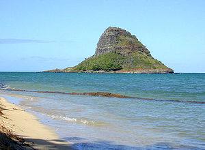
Kualoa point land is the northern end of Kāneohe Bay
. The small island Mokolii
, often called "Chinaman's Hat", is right offshore. The road is called Kamehameha Highway
, state route 83.
The park includes two small campgrounds administered by the City and County of Honolulu.
Oahu
Oahu or Oahu , known as "The Gathering Place", is the third largest of the Hawaiian Islands and most populous of the islands in the U.S. state of Hawaii. The state capital Honolulu is located on the southeast coast...
, Hawaii
Hawaii
Hawaii is the newest of the 50 U.S. states , and is the only U.S. state made up entirely of islands. It is the northernmost island group in Polynesia, occupying most of an archipelago in the central Pacific Ocean, southwest of the continental United States, southeast of Japan, and northeast of...
. Part of it is now the Kualoa Regional Park.
History
Kualoa Airfield was constructed in 1942 and used during World War IIWorld War II
World War II, or the Second World War , was a global conflict lasting from 1939 to 1945, involving most of the world's nations—including all of the great powers—eventually forming two opposing military alliances: the Allies and the Axis...
on land the military did not own. It was a satellite field for units assigned to Bellows Field and was used mainly for training.
The aircraft ramp was made of perforated high strength steel (Marston mats) that was used extensively by the military during World War II for quickly establishing airfields. Kualoa Field consisted of a single north/south runway. It was depicted as having a single 6,500' hard-surface runway. The road to Kaaawa and the north shore crossed over Kualoa's runway, so the cars would have to wait whenever an airplane took off.
The 28th Photographic Reconnaissance Squadron
28th Photographic Reconnaissance Squadron
The 28th Photographic Reconnaissance Squadron is an inactive United States Air Force unit. Its last assignment was with the 316th Bombardment Wing, being stationed at Kadena Air Base, Okinawa...
, operating P-38
P-38 Lightning
The Lockheed P-38 Lightning was a World War II American fighter aircraft built by Lockheed. Developed to a United States Army Air Corps requirement, the P-38 had distinctive twin booms and a single, central nacelle containing the cockpit and armament...
, F-4 and A-24 aircraft was stationed at Kualoa between October 9, 1944 and May 8, 1945.
The 18th Fighter Group, operating P-40
Curtiss P-40
The Curtiss P-40 Warhawk was an American single-engine, single-seat, all-metal fighter and ground attack aircraft that first flew in 1938. The P-40 design was a modification of the previous Curtiss P-36 Hawk which reduced development time and enabled a rapid entry into production and operational...
’s, also was stationed there briefly.
No evidence suggests that Kualoa was ever paved. The entire runway was formed of pierced steel planking. The steel planking makes a strong case that the military had no plans to keep Kualoa open any longer than it was needed.
Following the war the land was returned to the original owners.
Today
Ahupua'a O Kahana State Park
Ahupuaa O Kahana State Park, formerly Kahana Valley State Park, is located on the windward side of Oahu between Kaʻaʻawa and Punaluu. The park is located mauka from Kahana Bay. It is Hawaii's only public ahupuaa, and it stretches from the sea to the tip of Puu Pauao at 2670 feet...
and Kualoa Ranch
Kualoa Ranch
Kualoa Ranch is the landowner of Kaaawa Valley, also commonly known as Kualoa Valley, on the windward coast of the island of Oahu in Hawaii. This place was sacred to ancient Oahuans from the 13th to the 18th century, as it was where Laa-mai-kahiki settled after visiting Kauai and before returning...
. The only remaining aviation activity at the site is occasional use by model airplane flyers that use the grass field. A few of the fortified revetments along the shear cliffs above the former airfield still remain intact, as the only remaining indication of this site's military history.
Kualoa point land is the northern end of Kāneohe Bay
Kane'ohe Bay
Kāneohe Bay, at 45 km², is the largest sheltered body of water in the main Hawaiian Islands. This reef-dominated embayment constitutes a significant scenic and recreational feature along the windward coast of the Island of Oahu...
. The small island Mokolii
Mokolii
Mokolii is a , basalt island offshore of Kualoa Point, Oahu, in Kāne'ohe Bay, Hawaii, at . Geologically, it used to be connected to Oahu before erosion cut it off. It is also known as "Chinaman's Hat" for its likeness to the straw hats Chinese immigrants wore...
, often called "Chinaman's Hat", is right offshore. The road is called Kamehameha Highway
Kamehameha Highway
Kamehameha Highway is one of the main highways serving suburban and rural O‘ahu in the U.S. state of Hawaii. Starting from Nimitz Highway near Pearl Harbor and Hickam Air Force Base in Honolulu, it serves the island's older western suburbs, turning north across the O‘ahu Central Valley to the...
, state route 83.
The park includes two small campgrounds administered by the City and County of Honolulu.