

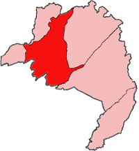
Kolahun District
Encyclopedia
Districts of Liberia
The counties of Liberia are subdivided into districts.*Bomi County**Dewoin District**Klay District**Mecca District**Senjeh District*Bong County**Fuamah District**Jorquelleh District**Kokoyah District**Panta-Kpa District**Salala District...
of Lofa County
Lofa County
Lofa is a county in the northernmost portion of the West African nation of Liberia. One of 15 counties that comprise the first-level of administrative division in the nation, it has six districts. Voinjama serves as the capital with the area of the county measuring...
in Liberia
Liberia
Liberia , officially the Republic of Liberia, is a country in West Africa. It is bordered by Sierra Leone on the west, Guinea on the north and Côte d'Ivoire on the east. Liberia's coastline is composed of mostly mangrove forests while the more sparsely populated inland consists of forests that open...
. It has an estimated population (July, 2004) of 26,827. Kolahun was the scene of heavy fighting between government troops and rebels during Liberia's second civil war
Second Liberian Civil War
The Second Liberian Civil War began in 1999 when a rebel group backed by the government of neighbouring Guinea, the Liberians United for Reconciliation and Democracy , emerged in northern Liberia. In early 2003, a second rebel group, the Movement for Democracy in Liberia, emerged in the south, and...
, causing massive shifts in population and destruction of property.