

Ko Nom Sao
Encyclopedia
Phang Nga Bay
Phang Nga Bay is a 400 km² bay in the Andaman Sea between the island of Phuket and the mainland of the Malay peninsula of southern Thailand. Since 1981, an extensive section of the bay has been protected as the Ao Phang Nga National Park...
, and are part of the Ko Panyi
Amphoe Mueang Phang Nga
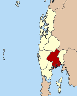
Mueang Phang Nga is the capital district of Phang Nga Province in southern Thailand.-Geography:Neighboring districts are Thap Put, Phanom of Surat Thani Province, Kapong, Thai Mueang and Takua Thung. To the south is the Phang Nga bay, with the insular district Ko Yao.The Ao Phang Nga National...
(เกาะปันหยี) subdistrict (tambon
Tambon
Tambon is a local government unit in Thailand. Below district and province , they form the third administrative subdivision level. As of the 2009 there are 7255 tambon, not including the 169 khwaeng of Bangkok, which are set at the same administrative level, thus every district contains 8-10 tambon...
), Phang Nga Province
Phang Nga Province
Phang Nga is one of the southern provinces of Thailand, on the shore to the Andaman Sea. Neighboring provinces are Ranong, Surat Thani and Krabi. To the south is the Phuket province, but without land boundary to Phang Nga....
, Thailand
Thailand
Thailand , officially the Kingdom of Thailand , formerly known as Siam , is a country located at the centre of the Indochina peninsula and Southeast Asia. It is bordered to the north by Burma and Laos, to the east by Laos and Cambodia, to the south by the Gulf of Thailand and Malaysia, and to the...
.
General
Ko Nom Sao is a geographical feature consisting of two small islands of similar appearance located close to each other. One of them, Ko Nom Sao Yai (เกาะนมสาวใหญ่), is slightly larger than the other, but from certain angles the silhouette of these islands looks like a pair of roughly identical woman's breasts.These islands are also known as Ko Ok Meri.
Similarly named features
- Ko Nom Sao in Khao Sam Roi Yot National ParkKhao Sam Roi Yot National ParkKhao Sam Roi Yot is a marine national park in Sam Roi Yot district, Prachuap Khiri Khan Province, Thailand. It covers 98.08 km², of which 20.88 km² are marine areas. The park was established in 1966, and was the first coastal national park of Thailand....
, Prachuap Khiri KhanPrachuap Khiri KhanPrachuap Khiri Khan is a town in southern Thailand. It is the capital of Prachuap Khiri Khan province and is on the coast at one of the narrowest stretches in Thailand, only 10 km from the Burmese border at Dansingkhorn. The town can reached from Bangkok by train from Hualampong Station or by...
. 12°13′N 100°01′E
- Ko Nom Sao, an island off the shore in Chanthaburi ProvinceChanthaburi ProvinceChanthaburi is a province of Thailand. It is located in the east of Thailand, at the border to Battambang and Pailin of Cambodia and the shore to the Gulf of Thailand...
. 12°28′N 102°01′E