
Knowle, Bristol
Encyclopedia
Wards of the United Kingdom
A ward in the United Kingdom is an electoral district at sub-national level represented by one or more councillors. It is the primary unit of British administrative and electoral geography .-England:...
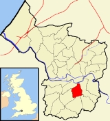
in the south of Bristol
Bristol
Bristol is a city, unitary authority area and ceremonial county in South West England, with an estimated population of 433,100 for the unitary authority in 2009, and a surrounding Larger Urban Zone with an estimated 1,070,000 residents in 2007...
. It is bordered by Filwood Park to the west, Brislington
Brislington
Brislington is an area in the south east of the city of Bristol, England. It is on the edge of Bristol and from Bath. The Brislington Brook runs through the area in the woodlands of Nightingale Valley...
to the east, Whitchurch
Whitchurch, Bristol
Whitchurch is a village in north Somerset, England and an adjoining suburb of south eastern Bristol, bounded by Hartcliffe to the west and Hengrove and Knowle to the north. The suburb was initially developed during the 1930s....
and Hengrove
Hengrove
Hengrove is a suburb and council ward of Bristol, England, situated between Whitchurch, Knowle and Bishopsworth, running along both dual carriageways, Wells Road and Airport Road . It consists mainly of working to middle class terrace houses. It contains an infant, primary and secondary school...
to the south and Totterdown to the north.
Broadwalk shopping centre provides the majority of the shopping facilities. The Wells Road runs through Knowle from Totterdown
Totterdown, Bristol
Totterdown is a suburb of Bristol, England, situated area just south of the River Avon and south-east of Temple Meads railway station. It rises relatively steeply from the river bank to a largely terraced Victorian housing area which is notable for its painted homes - often in bright colours - that...
to Whitchurch. Broadwalk is a tree lined boulevard that heads westwards towards Filwood. Redcatch Park is the main green space with football pitches, children's play area, a MUGA (Multi Games Area), tennis courts and a croquet club. This is supported by The Friends of Redcatch Park, a group of local residents helping Bristol City Council to enhance and protect this valuable local open space and who organise events in the park for local people. The library has recently reopened and is accessible from the roof car park of, as well as within, Broadwalk shopping centre.
There are many community groups that operate in and around the Knowle area. Redcatch Community Association run the Redcatch Centre in Redcatch Road, on the boundary of Redcatch Park - a valuable resource for a large number of community groups and private and public events. There are numerous local clubs and groups including The Knowle and Totterdown Local History Group, Redcatch Rollers (Short Mat Bowling), Redcatch Tea Dance, and Redcatch Art Club who all meet at Redcatch Community Centre. Knowle Community Association also run a community centre in The Square, Knowle Park with various activities including Knowle East Youth Club. Other organisations are Broad Walk Neighbourhood Watch, which acts as a portal for the local community of Knowle and those in and around Broad Walk, and the St John Ambulance Knowle & Totterdown Division (www.sja.org.uk/kt).
There are good views of the city just above Perrett's Park, along Sylvia Avenue which is lined by Victorian terraces.