

Kiso Valley
Encyclopedia
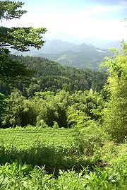
Valley
In geology, a valley or dale is a depression with predominant extent in one direction. A very deep river valley may be called a canyon or gorge.The terms U-shaped and V-shaped are descriptive terms of geography to characterize the form of valleys...
of the upper portions of the Kiso River
Kiso River
The is a river in Japan roughly 193 km long, flowing through the prefectures of Nagano, Gifu, Aichi, and Mie before emptying into Ise Bay a short distance away from the city of Nagoya. It is the main river of the Kiso Three Rivers and forms a major part of the Nōbi Plain...
in the southwestern part of Nagano Prefecture
Nagano Prefecture
is a prefecture of Japan located in the Chūbu region of the island of Honshū. The capital is the city of Nagano.- History :Nagano was formerly known as the province of Shinano...
in Japan
Japan
Japan is an island nation in East Asia. Located in the Pacific Ocean, it lies to the east of the Sea of Japan, China, North Korea, South Korea and Russia, stretching from the Sea of Okhotsk in the north to the East China Sea and Taiwan in the south...
. It is a v-shaped valley with length of approximately 60 km (36 mi) that follows the river as it flows from north by northwest to south by southwest into Gifu Prefecture
Gifu Prefecture
is a prefecture located in the Chūbu region of central Japan. Its capital is the city of Gifu.Located in the center of Japan, it has long played an important part as the crossroads of Japan, connecting the east to the west through such routes as the Nakasendō...
.
Access
Through much of Japan's history, the Kiso Valley was used to connect the former MinoMino Province
, one of the old provinces of Japan, encompassed part of modern-day Gifu Prefecture. It was sometimes called . Mino Province bordered Echizen, Hida, Ise, Mikawa, Ōmi, Owari, and Shinano Provinces....
and Shinano
Shinano Province
or is an old province of Japan that is now present day Nagano Prefecture.Shinano bordered on Echigo, Etchū, Hida, Kai, Kōzuke, Mikawa, Mino, Musashi, Suruga, and Tōtōmi Provinces...
provinces. However, it came to be known as a difficult route because of its steep climbs. The Shoku Nihongi
Shoku Nihongi
The is an imperially commissioned Japanese history text. Completed in 797, it is the second of the Six National Histories, coming directly after the Nihon Shoki and followed by Nihon Kōki. Fujiwara no Tsugutada and Sugano no Mamichi served as the primary editors...
recorded that the Kiso no Yamamichi (岐蘇山道) was opened in 702
702
Year 702 was a common year starting on Sunday of the Julian calendar. The denomination 702 for this year has been used since the early medieval period, when the Anno Domini calendar era became the prevalent method in Europe for naming years.- Europe :* Franconian Duke Hetan II completes the...
. The same route was again mentioned in a 713
713
Year 713 was a common year starting on Sunday of the Julian calendar. The denomination 713 for this year has been used since the early medieval period, when the Anno Domini calendar era became the prevalent method in Europe for naming years.- Byzantine Empire :* Byzantine Emperor Philippicus is...
article, but it was then called the Kisoji no Michi (吉蘇路). The Kisoji
Kisoji
The was an old trade route in the Kiso Valley that stretched from Niekawa-juku in Nagano Prefecture to Magome-juku in Gifu Prefecture. There were eleven resting spots along the route, all of which became part of the Nakasendō when it was established...
(木曽路) would eventually follow the same path. However the official Tōsandō
Tosando
was an old Japanese geographical region that made up the gokishichidō system and was situated along the central mountains of northern Honshū, Tōhoku region....
did not run through the Kiso Valley; instead, it ran from Mino Province towards the Kamisaka Pass and into the Ina Valley. During Japan's Middle Ages, the Nakasendō
Nakasendo
The , also called the , was one of the five routes of the Edo period, and one of the two that connected Edo to Kyoto in Japan. There were 69 stations between Edo and Kyoto, crossing through Musashi, Kōzuke, Shinano, Mino and Ōmi provinces...
, an old trade route, ran through the valley, which led to the creation of eleven post stations
Shukuba
were post stations during the Edo period in Japan, generally located on one of the Edo Five Routes or one of its sub-routes. They were also called shukueki . These post stations were places where travelers could rest on their journey around the nation...
along the route. Since the Meiji period
Meiji period
The , also known as the Meiji era, is a Japanese era which extended from September 1868 through July 1912. This period represents the first half of the Empire of Japan.- Meiji Restoration and the emperor :...
, the Chūō Main Line
Chuo Main Line
The , commonly called the Chūō Line, is one of the major trunk railway lines in Japan. It runs between Tokyo and Nagoya, although it is the slowest direct railway connection between the two cities; the coastal Tōkaidō Main Line is slightly faster, while the Tōkaidō Shinkansen is the fastest rail...
(for trains) and Route 19 (for vehicles) have been cutting through the valley.
Communities
The following communities are part of the Kiso Valley:Nagano Prefecture
- Kiso DistrictKiso District, Naganois a district located in Nagano Prefecture, Japan.As of November 1, 2005, the district has an estimated population of 34,759. The total area is 1,546.26 km².Historically, the district was once known as Nishichikuma District until May 1, 1968....
(including Tsumago-juku, a former post townShukubawere post stations during the Edo period in Japan, generally located on one of the Edo Five Routes or one of its sub-routes. They were also called shukueki . These post stations were places where travelers could rest on their journey around the nation...
, 35.5753°N 137.5951°W) - Ōtaki, NaganoOtaki, Naganois a village located in Kiso District, Nagano, Japan.- History :* 1504: There remains a record of Ōtaki being established at this time as part of the Chikuma Region of Shinano* 1868: Takigoshi Village is incorporated as part of Ōtaki....
(35°49′N 137°33′E) - ShiojiriShiojiri, Naganois a city located in Nagano, Japan. Its name literally means "the end of salt".-History:Municipal Area Changes* April 1, 1927-The village of Shiojiri gained town status....
(36°7′N 137°57′E) - MatsumotoMatsumoto, Naganois a city located in Nagano Prefecture, Japan. Matsumoto is designated as a Special City.-Outline:The new city of Matsumoto is the city comprising the mergers of the old city of Matsumoto and four villages. Matsumoto officially absorbed those villages without creating a new municipal...
(36°14′N 137°58′E)
Gifu Prefecture
- NakatsugawaNakatsugawa, Gifuis a city located in the Tōnō region of Gifu Prefecture, Japan. The city was founded on April 1, 1952.-History:During Japan's Edo period, Nakatsugawa was a post town, known as Nakatsugawa-juku, one of the 69 Stations of the Nakasendō along the Nakasendō. The travel route ran from the Nihonbashi in...
(35°29′N 137°30′E), including Magome-juku, another former post town