
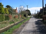
Kirby Grindalythe
Encyclopedia
.jpg)
Civil parish
In England, a civil parish is a territorial designation and, where they are found, the lowest tier of local government below districts and counties...
in the Ryedale
Ryedale
Ryedale is a non-metropolitan district of the shire county of North Yorkshire in England. Settlements include Helmsley, Kirkbymoorside, Malton, Norton-on-Derwent, Pickering, and Terrington.-Derivation of name:...
district of North Yorkshire
North Yorkshire
North Yorkshire is a non-metropolitan or shire county located in the Yorkshire and the Humber region of England, and a ceremonial county primarily in that region but partly in North East England. Created in 1974 by the Local Government Act 1972 it covers an area of , making it the largest...
, England
England
England is a country that is part of the United Kingdom. It shares land borders with Scotland to the north and Wales to the west; the Irish Sea is to the north west, the Celtic Sea to the south west, with the North Sea to the east and the English Channel to the south separating it from continental...
. It is located about eight miles south east of Malton
Malton, North Yorkshire
Malton is a market town and civil parish in North Yorkshire, England. The town is the location of the offices of Ryedale District Council and has a population of around 4,000 people....
. The name of the village is derived from Old Norse. Kirby kirkiubỹr means "village with a church", the Grindal element is a distortion of Crandale, meaning "valley with cranes" and lythe is from Old Norse "hlíõ" meaning slope.
Kirby Grindalythe village has a resident population of roughly fifty. There are no shops, and the nearest town is Malton. The village is the location of the Cranedale Centre, a residential Field Studies Centre providing courses in environmental subjects and outdoor education to people of all ages. The church of St Andrew's at Kirby Grindalythe is on the Sykes Churches Trail
Sykes Churches Trail
The Sykes Churches Trail is a tour of East Yorkshire churches which were built, rebuilt or restored by the Sykes family of Sledmere House in the East Riding of Yorkshire, England...
having been restored by Sir Tatton Sykes in 1872–5 and again more recently after a grant of about £175,000 from English Heritage. The church is now a Grade II* listed building.
The civil parish of Kirby Grindalythe, which includes the village of Duggleby
Duggleby
Duggleby is a village in the Ryedale district of North Yorkshire, England. To the south-east of the village is Duggleby Howe one of the largest round barrows in Britain. The civil parish of Kirby Grindalythe, which includes the village of Duggleby , had a population of 247 people living in 92...
, had a population of 247 people living in 92 households at the time of the last census in 2001.
High Mowthorpe
Also in the civil parish is the former hamlet of High Mowthorpe (54.10819°N 0.64231°W), which is now an ADAS farm and arable research centre. The farm is a mixed arable and livestock farm, covering 437 hectares (1,079.8 acre) with 97 hectares (239.7 acre) managed organically. Laboratory and glasshouse facilities are located on the site as well as a weather station providing data to the Met Office
Met Office
The Met Office , is the United Kingdom's national weather service, and a trading fund of the Department for Business, Innovation and Skills...
.
High Mowthorpe is also the home of ADAS Pest Evaluation Services, which processes approximately 4,000 soil and plant samples annually to determine pest and disease levels.