

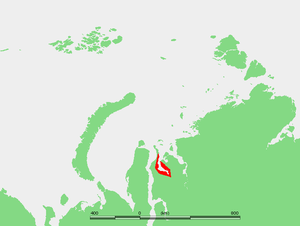
Khalmyer Bay
Encyclopedia
Kara Sea
The Kara Sea is part of the Arctic Ocean north of Siberia. It is separated from the Barents Sea to the west by the Kara Strait and Novaya Zemlya, and the Laptev Sea to the east by the Severnaya Zemlya....
. It is located in the Gydan Peninsula
Gydan Peninsula
The Gydan Peninsula is a geographical feature of the Siberian coast in the Kara Sea. It is roughly 500 km long and 260 km wide. This wide peninsula lies between the estuaries of the Ob and Yenisei Rivers , which are two of the most important rivers of Russia and the world...
and it is roughly 185 km long and 47 km wide at its widest point. Lat 71°30′ N, long 76° E
76th meridian east
The meridian 76° east of Greenwich is a line of longitude that extends from the North Pole across the Arctic Ocean, Asia, the Indian Ocean, the Southern Ocean, and Antarctica to the South Pole....
.
This deep bay lies between the estuaries of the Ob
Ob River
The Ob River , also Obi, is a major river in western Siberia, Russia and is the world's seventh longest river. It is the westernmost of the three great Siberian rivers that flow into the Arctic Ocean .The Gulf of Ob is the world's longest estuary.-Names:The Ob is known to the Khanty people as the...
(Gulf of Ob
Gulf of Ob
The Gulf of Ob is a gigantic bay of the Arctic Ocean, located in Northern Russia at the head the mouth of the Ob River....
) and the Yenisei River
Yenisei Gulf
The Yenisei Gulf is a large and long estuary through which the lower Yenisei River flows into the Kara Sea.The Yenisei Gulf is formed by the river widening to an average of 50 km for up to 250 km in a roughly north-south direction, between a latitude of 70° 30' N in the area around...
, which are two of the most important rivers of Russia and the world. The peninsula formed between this bay and neighboring Yuratski Bay
Yuratski Bay
The Yuratski Bay is an inlet on the Siberian coast in the Kara Sea. It is located in the Gydan Peninsula and it is roughly 45 km long and 30 km wide at its widest point...
is known as the Mamonta Peninsula (Poluostrov Mamonta).
The Khalmyer Bay is surrounded by tundra coast and there are numerous river mouths on its shores. Deep within the bay lie the settlements of Chernyy Mys and Gyda. At its mouth lie the settlements of Matyuysale and Mongatalyang.
This Bay is located in the Yamal-Nenets autonomous district administrative region of the Russian Federation.
The Khalmyer Bay appears also as Gydanskaya Guba in some maps in English.