
Kent Land District, Tasmania
Encyclopedia
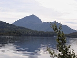
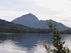
Kent Land District is one of the twenty land districts of Tasmania
which are part of the Cadastral divisions of Tasmania
. It was formerly one of the 18 counties of Tasmania
. It is located on the southern tip of Tasmania. It is bordered by the Huon River
to the north, and Picton River to the north-west. It includes Dover, Geeveston
and Southport, and part of the Southwest National Park
.
proclaimed, via The Hobart Town Courier
, the first counties and parishes to be surveyed in the colony.
No hundreds and parishes were proclaimed for Kent County at this time.
Tasmania
Tasmania is an Australian island and state. It is south of the continent, separated by Bass Strait. The state includes the island of Tasmania—the 26th largest island in the world—and the surrounding islands. The state has a population of 507,626 , of whom almost half reside in the greater Hobart...
which are part of the Cadastral divisions of Tasmania
Cadastral divisions of Tasmania
The Lands administrative divisions of Tasmania refer to the division of Tasmania into land districts and parishes for cadastral purposes, which are part of the lands administrative divisions of Australia...
. It was formerly one of the 18 counties of Tasmania
Counties of Tasmania
The 18 former counties of Tasmania, renamed as Land Districts:*Arthur County*Buckingham County*Cornwall County*Cumberland County*Devon County*Dorset County*Franklin County*Glamorgan County*Kent County*Lincoln County*Monmouth County*Montagu County...
. It is located on the southern tip of Tasmania. It is bordered by the Huon River
Huon River
The Huon River is the fourth largest river in Tasmania, Australia. It is 170 km in length, and runs through the fertile Huon Valley. From Scotts Peak Dam at Lake Pedder where it begins, it flows south-east to the Tahune Airwalk, where the Picton River joins, before heading through the rural...
to the north, and Picton River to the north-west. It includes Dover, Geeveston
Geeveston, Tasmania
Geeveston is a small Australian town located in the south of Tasmania on the Huon River, 62 km south west of Hobart, making it Australia's most southerly administrative centre. The town takes its name from William Geeves, an English settler who was given a land grant by Lady Jane Franklin in the...
and Southport, and part of the Southwest National Park
Southwest National Park
The Southwest National Park is a national park located in the south-west of Tasmania, Australia. The park is Tasmania's largest and forms part of the Tasmanian Wilderness World Heritage Area....
.
The original parishes
On 15 January 1836 George Arthur, the Lieutenant Governor of the Island of Van Diemen's LandVan Diemen's Land
Van Diemen's Land was the original name used by most Europeans for the island of Tasmania, now part of Australia. The Dutch explorer Abel Tasman was the first European to land on the shores of Tasmania...
proclaimed, via The Hobart Town Courier
The Courier (Hobart)
The Courier is a newspaper founded in 1827 in Hobart, Tasmania, as the Hobart Town Courier. It changed names to the Hobart Town Courier and Van Diemen's Land Advertiser in 1839, settling on The Courier in 1840. In 1859 it merged with The Hobart Town Daily Mercury.-References:* from the Mercury...
, the first counties and parishes to be surveyed in the colony.
Ihe County of Kent, bounded on the north bv the river Davey, and by a line to the river Picton, and by that river to its junction with the river Huon, thence on the north and on the east by the river Huon to the sea, and on the south and west by the sea. This county to include all islands situate between Whale head and North Head (Port Davey).
No hundreds and parishes were proclaimed for Kent County at this time.