

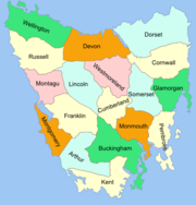
Cadastral divisions of Tasmania
Encyclopedia
Tasmania
Tasmania is an Australian island and state. It is south of the continent, separated by Bass Strait. The state includes the island of Tasmania—the 26th largest island in the world—and the surrounding islands. The state has a population of 507,626 , of whom almost half reside in the greater Hobart...
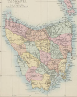
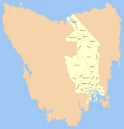
into land districts and parishes for cadastral purposes, which are part of the lands administrative divisions of Australia. There are 20 land districts in Tasmania, although in the early nineteenth century there were several other systems, with 18 or 36 counties and 9 other divisions used, as well as hundreds. The land districts include the 18 former counties of the island of Tasmania which were renamed but retain the same boundaries, plus King Island and Flinders Island
Flinders Island
Flinders Island may refer to:In Australia:* Flinders Island , in the Furneaux Group, is the largest and best known* Flinders Island * Flinders Island , in the Investigator Group* Flinders Island...
. The counties are referenced in the 1911 Britannica, with Hobart
Hobart
Hobart is the state capital and most populous city of the Australian island state of Tasmania. Founded in 1804 as a penal colony,Hobart is Australia's second oldest capital city after Sydney. In 2009, the city had a greater area population of approximately 212,019. A resident of Hobart is known as...
described as being in Buckingham County , Launceston
Launceston, Tasmania
Launceston is a city in the north of the state of Tasmania, Australia at the junction of the North Esk and South Esk rivers where they become the Tamar River. Launceston is the second largest city in Tasmania after the state capital Hobart...
in Cornwall County and Beaconsfield
Beaconsfield, Tasmania
Beaconsfield is a town near the Tamar River, in the north-east of Tasmania, Australia. It lies 40 kilometres north of Launceston on the West Tamar Highway. It is part of the Municipality of West Tamar...
in Devon County . The land districts are used for land titles today, while the Local Government Areas of Tasmania
Local Government Areas of Tasmania
- Local Government Areas of Tasmania, Australia :This article also includes lists of towns, suburbs and localities of Tasmania.-Brighton Council:*Hobart suburbs:**Bridgewater - Gagebrook - Old Beach*Brighton*Pontville*Tea Tree-City of Clarence:...
with cities and municipalities are used for political and administrative purposes.
Two counties
Tasmania was initially divided into two counties on 24 September 1804; Buckingham in the south, and Cornwall in the north. Cornwall was governed by William PatersonWilliam Paterson (explorer)
Colonel William Paterson, FRS was a Scottish soldier, explorer, Lieutenant governor and botanist best known for leading early settlement in Tasmania. This botanist is denoted by the author abbreviation Paterson when citing a botanical name.-Early years:A native of Montrose, Scotland, Paterson was...
, with Buckingham governed by David Collins
David Collins (governor)
Colonel David Collins was the first Lieutenant Governor of the Colony of Van Diemens Land, founded in 1804, which in 1901 became the state of Tasmania in the Commonwealth of Australia.-Early life and military career:...
.
20 land districts
The 18 counties are shown in most maps of Tasmania in the mid to late nineteenth and earlier twentieth century. These counties are subdivided into parishes, and use the same names and boundaries that the land districts do, which are used for cadastral purposes today. The counties in the east and centre were proclaimed by 1850, while the western counties of Wellington, Russel, Montague, Lincoln, Franklin, Montgomery and Arthur were proclaimed during the 1850s.- Arthur Land District
- Buckingham Land District
- Cornwall Land District
- Cumberland Land District
- Devon Land District
- Dorset Land District
- Flinders Land District
- Franklin Land District
- Glamorgan Land District
- Kent Land DistrictKent Land District, TasmaniaKent Land District is one of the twenty land districts of Tasmania which are part of the Cadastral divisions of Tasmania. It was formerly one of the 18 counties of Tasmania. It is located on the southern tip of Tasmania. It is bordered by the Huon River to the north, and Picton River to the...
- King Land DistrictKing Land DistrictKing Land District is a land district of Western Australia, located within the Kimberley Division of the state....
- Lincoln Land District
- Monmouth Land District
- Montagu Land District
- Montgomery Land District
- Pembroke Land District
- Russell Land DistrictRussell Land DistrictRussell Land District is one of the twenty land districts of Tasmania which are part of the Cadastral divisions of Tasmania. It was formerly one of the 18 counties of Tasmania....
- Somerset Land DistrictSomerset Land DistrictSomerset Land District is one of the twenty land districts of Tasmania which are part of the Cadastral divisions of Tasmania. It was formerly one of the 18 counties of Tasmania.-The original parishes:...
- Wellington Land District, TasmaniaWellington Land District, TasmaniaWellington Land District is one of the twenty land districts of Tasmania which are part of the Cadastral divisions of Tasmania. It was formerly one of the 18 counties of Tasmania....
- Westmoreland Land DistrictWestmoreland Land DistrictWestmoreland Land District is one of the twenty land districts of Tasmania which are part of the Cadastral divisions of Tasmania. It was formerly one of the 18 counties of Tasmania.-The original parishes:...
Other divisions
Launceston, Tasmania
Launceston is a city in the north of the state of Tasmania, Australia at the junction of the North Esk and South Esk rivers where they become the Tamar River. Launceston is the second largest city in Tasmania after the state capital Hobart...
, Norfolk Plains, Campbelltown, Clyde, Oatlands
Oatlands, Tasmania
Oatlands is an important historical village built on the shores of Lake Dulverton in the centre of Tasmania, Australia. Oatlands is located 84 km north of Hobart and 115 km south of Launceston on the Midland Highway...
, Oyster Bay, New Norfolk
New Norfolk, Tasmania
-References:5. Fellowship of First Fleeters.6. New Norfolk's History and Achievements by Joe Cowburn and Rita Cox 1986-External links:* has extensive local information, history, photographs, resources and attractions...
, Richmond
Richmond, Tasmania
Richmond is a town in Tasmania about 25 km north-east of Hobart, in the Coal River region, between the Midland Highway and Tasman Highway. At the 2006 census, Richmond had a population of 880....
and Hobart Town.
Tasmania also had hundreds in the early days of the colony under Governor Arthur
George Arthur
Lieutenant-General Sir George Arthur, 1st Baronet KCH PC was Lieutenant Governor of British Honduras , Van Diemen's Land and Upper Canada . He also served as Governor of Bombay .-Early life:George Arthur was born in Plymouth, England...
, with each 100 square miles (259 km²) hundred being divided into four 25 square miles (64.7 km²) parishes. A formal list of counties, hundreds and parishes was gazetted on 1 July 1836.
Early districts
Census
A census is the procedure of systematically acquiring and recording information about the members of a given population. It is a regularly occurring and official count of a particular population. The term is used mostly in connection with national population and housing censuses; other common...
) mentions 32 districts or towns by name:
Hobart Town, Argyle, Queenborough, Kingborough, Glenorchy, New Norfolk, Sorell, Clarence Plains, York, Cambridge, Ulva, Ormaig, Staffa, Caledon, Gloucester, Sussex, Harrington, Melville, Drummond, Strangford, Jarvis, Forbes, Green Ponds, Bath, Methven, Murray , Amherst, Lennox, Richmond, Norfolk Plains, Bathurst and Launceston.
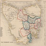
This 1846 map shows the eleven counties thus far surveyed outlined, with parishes where existing. J. Archer's 1855 map shows a similar situation but with more bounded smaller subdivisions (including parishes) and the old unbounded district names superimposed, where appropriate. Subdivisions of counties include:
- Georgetown
- LauncestonLaunceston, TasmaniaLaunceston is a city in the north of the state of Tasmania, Australia at the junction of the North Esk and South Esk rivers where they become the Tamar River. Launceston is the second largest city in Tasmania after the state capital Hobart...
- South Esk
- North Esk
- Norfolk Plains
- Western River
- Lake River
- Bathurst
- Lennox
- RichmondRichmond, TasmaniaRichmond is a town in Tasmania about 25 km north-east of Hobart, in the Coal River region, between the Midland Highway and Tasman Highway. At the 2006 census, Richmond had a population of 880....
- Methven
- Amherst
- Staffa
- Bath
- Murray
- SorellSorell, TasmaniaSorell is a town in Tasmania, Australia, north-east of Hobart. It is on the Tasman Highway which continues up the east coast of Tasmania. At the 2006 census, Sorell had a population of 1,546....
- Green Ponds
- Ormaig
- Harrington
- Gloucester
- Caledon
- Ulva
- Jarvis
- Strangford
- Macquarie
- New NorfolkNew Norfolk, Tasmania-References:5. Fellowship of First Fleeters.6. New Norfolk's History and Achievements by Joe Cowburn and Rita Cox 1986-External links:* has extensive local information, history, photographs, resources and attractions...
- Melville
- Drummond
- Queenboro
- Sussex
- Clarence Plains
- CambridgeCambridge, TasmaniaCambridge is a suburb in the greater area of Hobart, capital of Tasmania, Australia. It is in the City of Clarence Local Government Area. The suburb is situated in close proximity with Hobart International Airport and the Cambridge Aerodrome, and is approximately 18 km to Hobart via the Tasman...
- Forbes
- GlenorchyGlenorchy, TasmaniaGlenorchy is a business district and suburb in the northern part of greater Hobart, capital of the state of Tasmania, Australia. The land was originally used for agriculture but is now a largely suburban, working-class area...
- Argyle
- Kingboro