
Kennicott, Alaska
Encyclopedia
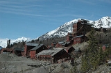
Kennecott, also known as Kennecott Mines or AHRS Site No. XMC-001, is an abandoned mining camp in the Valdez-Cordova Census Area
in the U.S. state
of Alaska
that was the center of activity for several copper
mine
s. It is located beside the Kennicott Glacier
, northeast of Valdez
, inside Wrangell-St. Elias National Park and Preserve
. The camp and mines are now a National Historic Landmark District administered by the National Park Service
.
It was declared a National Historic Landmark
in 1986.
s, Jack Smith and Clarence Warner, spotted a green patch of hillside that looked like good grazing for their pack horses. The green turned out to be part of a mountain of copper ore. They, together with nine friends, formed the Chitina Mining and Exploration Company. Shortly after this time, a U.S. Geological Survey geologist
found a sample of ore that analyzed as containing 70% copper as well as silver
and traces of gold
. Stephen Birch, a mining engineer just out of school, was in Valdez when members of the Chitina Mining and Exploration Company arrived in the fall of 1900. Birch, who knew wealthy people in the northeastern United States, bought the prospectors' interest in the mine for $275,000. Within twenty years, the find proved to be the richest known concentration of copper in the world.
Development of the mines began immediately. Ore was taken out by pack horses on a trail to Valdez. Political battles over the mining and subsequent railroad were fought in the office of U.S. President
Theodore Roosevelt
between conservationists and those having a financial interest in the copper.
In 1903, additional financing for the mining came from the Guggenheim family
and J.P. Morgan, who formed the Kennecott Copper Corporation in 1903. The corporation and company town were named after Kennicott Glacier
, which was situated in the valley below the town. The glacier was named after Robert Kennicott
, a naturalist who explored in Alaska in the mid-19th century. Due to a clerical error, the corporation and town used the spelling of "Kennecott" instead of "Kennicott." It is occasionally also seen as "Kennycott."
Kennecott had five mines: Bonanza, Jumbo, Mother Lode, Erie and Glacier. Glacier, which is really an ore extension of the Bonanza, was an open-pit mine and was only mined during the summer. Bonanza and Jumbo were on Bonanza Ridge about 5 km, (3 miles) from Kennecott. The Mother Lode mine was located on the east side of the ridge from Kennecott. The Bonanza, Jumbo, Mother Lode and Erie mines were connected by tunnels. The Erie mine was perched on the northwest end of Bonanza Ridge overlooking Root Glacier about 6 km (3.7 mi) up a glacial trail from Kennecott. Ore was hoisted to Kennecott via the trams which head-ended at Bonanza and Jumbo. From Kennecott the ore was hauled mostly in 140-pound sacks on steel flat cars to Cordova
, 196 rail miles away on the Copper River and Northwestern Railway
(CRNW).
On April 8, 1911, the first ore train hauled $250,000 of 70% copper ore. In 1916, the peak year for production, the mines produced copper ore valued at $32.4 million.
 In 1925 a Kennecott geologist predicted that the end of the high-grade ore bodies was in sight. The highest grades of ore were largely depleted by the early 1930s. The Glacier Mine closed in 1929. The Mother Lode was next, closing at the end of July 1938. The final three, Erie, Jumbo and Bonanza, closed that September. The last train left Kennecott on November 10, 1938, leaving it a ghost town. In the 27 years of operation, except for 2½ years of shutdown, Kennecott produced 4.625 million tons of ore averaging 13 per cent copper valued at roughly $207,000,000 with an estimated profit of $100,000,000. In addition, the silver by-product from this operation brought in another 4½ to 9 million dollars in revenues.
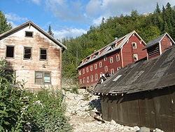
From 1939 until the mid-1950s, Kennecott was deserted except for a family of three who served as the watchmen until about 1952. In the late 1960s, an attempt was made to reprocess the tailings and to transport the ore in aircraft. The cost of doing so made the idea unprofitable. Around the same time, the company with land rights ordered the destruction of the town to rid them of liability for potential accidents. A few structures were destroyed, but the job was never finished and most of the town was left standing. Visitors and nearby residents have stripped many of the small items and artifacts. Some have since been returned and are held in various archives.
or on private land in the surrounding area. The area was designated a National Historic Landmark
in 1986 and the National Park Service
acquired much of the land within the Kennecott Mill Town in 1998. The National Park Service is currently stabilizing and rehabilitating many of the mill and town buildings. Some of the structures, as well as surrounding lands, remain under private ownership. Tours of the mill town are available three times a day through a local guide service, St. Elias Alpine Guides.
Popular tourist activities while visiting Kennecott include glacier
hiking, ice climbing
, and touring the abandoned mill. Visitors may also hike to the abandoned Bonanza, Jumbo and Erie mines, all of which are strenuous full-day hikes, with Erie Mine being a somewhat terrifying scramble along cliffs overlooking the Stairway Icefall. Local guide services offer all of these hikes if one would like some route-finding assistance.
to the McCarthy Road
, an unimproved gravel road. The McCarthy Road ends at the Kennicott River and a footbridge is available for pedestrian traffic to McCarthy. From McCarthy, it is 4.5 miles (7.2 km) to Kennecott, and shuttles are available.
Valdez-Cordova Census Area, Alaska
Valdez-Cordova Census Area is a census area located in the state of Alaska, United States. As of the 2000 census, the population was 10,195. It is part of the unorganized borough and therefore has no borough seat...
in the U.S. state
U.S. state
A U.S. state is any one of the 50 federated states of the United States of America that share sovereignty with the federal government. Because of this shared sovereignty, an American is a citizen both of the federal entity and of his or her state of domicile. Four states use the official title of...
of Alaska
Alaska
Alaska is the largest state in the United States by area. It is situated in the northwest extremity of the North American continent, with Canada to the east, the Arctic Ocean to the north, and the Pacific Ocean to the west and south, with Russia further west across the Bering Strait...
that was the center of activity for several copper
Copper
Copper is a chemical element with the symbol Cu and atomic number 29. It is a ductile metal with very high thermal and electrical conductivity. Pure copper is soft and malleable; an exposed surface has a reddish-orange tarnish...
mine
Mining
Mining is the extraction of valuable minerals or other geological materials from the earth, from an ore body, vein or seam. The term also includes the removal of soil. Materials recovered by mining include base metals, precious metals, iron, uranium, coal, diamonds, limestone, oil shale, rock...
s. It is located beside the Kennicott Glacier
Kennicott Glacier
Kennicott Glacier is a glacier in the U.S. state of Alaska. It trends southeast 43 km from Mount Blackburn to its terminus at the head of the Kennicott River in the Wrangell Mountains. It is located in the middle of Wrangell-St...
, northeast of Valdez
Valdez, Alaska
Valdez is a city in Valdez-Cordova Census Area in the U.S. state of Alaska. According to 2005 Census Bureau estimates, the population of the city is 4,020. The city is one of the most important ports in Alaska. The port of Valdez was named in 1790 after the Spanish naval officer Antonio Valdés y...
, inside Wrangell-St. Elias National Park and Preserve
Wrangell-St. Elias National Park and Preserve
Wrangell–St. Elias National Park and Preserve is a United States National Park in southeastern Alaska. It was established in 1980 by the Alaska National Interest Lands Conservation Act. The park area is included in an International Biosphere Reserve and is part of a UNESCO World Heritage Site...
. The camp and mines are now a National Historic Landmark District administered by the National Park Service
National Park Service
The National Park Service is the U.S. federal agency that manages all national parks, many national monuments, and other conservation and historical properties with various title designations...
.
It was declared a National Historic Landmark
National Historic Landmark
A National Historic Landmark is a building, site, structure, object, or district, that is officially recognized by the United States government for its historical significance...
in 1986.
History
In August 1900, two prospectorProspecting
Prospecting is the physical search for minerals, fossils, precious metals or mineral specimens, and is also known as fossicking.Prospecting is a small-scale form of mineral exploration which is an organised, large scale effort undertaken by mineral resource companies to find commercially viable ore...
s, Jack Smith and Clarence Warner, spotted a green patch of hillside that looked like good grazing for their pack horses. The green turned out to be part of a mountain of copper ore. They, together with nine friends, formed the Chitina Mining and Exploration Company. Shortly after this time, a U.S. Geological Survey geologist
Geologist
A geologist is a scientist who studies the solid and liquid matter that constitutes the Earth as well as the processes and history that has shaped it. Geologists usually engage in studying geology. Geologists, studying more of an applied science than a theoretical one, must approach Geology using...
found a sample of ore that analyzed as containing 70% copper as well as silver
Silver
Silver is a metallic chemical element with the chemical symbol Ag and atomic number 47. A soft, white, lustrous transition metal, it has the highest electrical conductivity of any element and the highest thermal conductivity of any metal...
and traces of gold
Gold
Gold is a chemical element with the symbol Au and an atomic number of 79. Gold is a dense, soft, shiny, malleable and ductile metal. Pure gold has a bright yellow color and luster traditionally considered attractive, which it maintains without oxidizing in air or water. Chemically, gold is a...
. Stephen Birch, a mining engineer just out of school, was in Valdez when members of the Chitina Mining and Exploration Company arrived in the fall of 1900. Birch, who knew wealthy people in the northeastern United States, bought the prospectors' interest in the mine for $275,000. Within twenty years, the find proved to be the richest known concentration of copper in the world.
Development of the mines began immediately. Ore was taken out by pack horses on a trail to Valdez. Political battles over the mining and subsequent railroad were fought in the office of U.S. President
President of the United States
The President of the United States of America is the head of state and head of government of the United States. The president leads the executive branch of the federal government and is the commander-in-chief of the United States Armed Forces....
Theodore Roosevelt
Theodore Roosevelt
Theodore "Teddy" Roosevelt was the 26th President of the United States . He is noted for his exuberant personality, range of interests and achievements, and his leadership of the Progressive Movement, as well as his "cowboy" persona and robust masculinity...
between conservationists and those having a financial interest in the copper.
In 1903, additional financing for the mining came from the Guggenheim family
Guggenheim family
The Guggenheim family is an American family, of Swiss Jewish ancestry. Beginning with Meyer Guggenheim, who arrived in America in 1847, the family were known for their global successes in mining and smelting . During the 19th century, the family possessed one of the largest fortunes in the world...
and J.P. Morgan, who formed the Kennecott Copper Corporation in 1903. The corporation and company town were named after Kennicott Glacier
Kennicott Glacier
Kennicott Glacier is a glacier in the U.S. state of Alaska. It trends southeast 43 km from Mount Blackburn to its terminus at the head of the Kennicott River in the Wrangell Mountains. It is located in the middle of Wrangell-St...
, which was situated in the valley below the town. The glacier was named after Robert Kennicott
Robert Kennicott
Robert Kennicott was an American naturalist.-Biography:Kennicott was born in New Orleans and grew up in "West Northfield" , Illinois, a town in the prairie north of the then nascent city of Chicago....
, a naturalist who explored in Alaska in the mid-19th century. Due to a clerical error, the corporation and town used the spelling of "Kennecott" instead of "Kennicott." It is occasionally also seen as "Kennycott."
Kennecott had five mines: Bonanza, Jumbo, Mother Lode, Erie and Glacier. Glacier, which is really an ore extension of the Bonanza, was an open-pit mine and was only mined during the summer. Bonanza and Jumbo were on Bonanza Ridge about 5 km, (3 miles) from Kennecott. The Mother Lode mine was located on the east side of the ridge from Kennecott. The Bonanza, Jumbo, Mother Lode and Erie mines were connected by tunnels. The Erie mine was perched on the northwest end of Bonanza Ridge overlooking Root Glacier about 6 km (3.7 mi) up a glacial trail from Kennecott. Ore was hoisted to Kennecott via the trams which head-ended at Bonanza and Jumbo. From Kennecott the ore was hauled mostly in 140-pound sacks on steel flat cars to Cordova
Cordova, Alaska
As of the census of 2000, there were 2,454 people, 958 households, and 597 families residing in the city. The population density was 40.0 per square mile . There are 1,099 housing units at an average density of 17.9 per square mile...
, 196 rail miles away on the Copper River and Northwestern Railway
Copper River and Northwestern Railway
The Copper River and Northwestern Railway was a railroad built by the Kennecott Corporation between 1907 and 1911 to take copper ore from Kennicott, Alaska to Cordova, Alaska, a distance of . The railroad was built by thousands of workers, who laid tracks around glaciers, across canyons and...
(CRNW).
On April 8, 1911, the first ore train hauled $250,000 of 70% copper ore. In 1916, the peak year for production, the mines produced copper ore valued at $32.4 million.
From 1939 until the mid-1950s, Kennecott was deserted except for a family of three who served as the watchmen until about 1952. In the late 1960s, an attempt was made to reprocess the tailings and to transport the ore in aircraft. The cost of doing so made the idea unprofitable. Around the same time, the company with land rights ordered the destruction of the town to rid them of liability for potential accidents. A few structures were destroyed, but the job was never finished and most of the town was left standing. Visitors and nearby residents have stripped many of the small items and artifacts. Some have since been returned and are held in various archives.
Tourism
In the 1980s, Kennecott became a popular tourist destination, as people came to see the old mines and buildings. However, the town of Kennecott was never repopulated. Residents involved in the tourism industry often lived in nearby McCarthyMcCarthy, Alaska
McCarthy is a census-designated place in Valdez-Cordova Census Area, Alaska, United States. The population was 42 at the 2000 census.- Geography and location:...
or on private land in the surrounding area. The area was designated a National Historic Landmark
National Historic Landmark
A National Historic Landmark is a building, site, structure, object, or district, that is officially recognized by the United States government for its historical significance...
in 1986 and the National Park Service
National Park Service
The National Park Service is the U.S. federal agency that manages all national parks, many national monuments, and other conservation and historical properties with various title designations...
acquired much of the land within the Kennecott Mill Town in 1998. The National Park Service is currently stabilizing and rehabilitating many of the mill and town buildings. Some of the structures, as well as surrounding lands, remain under private ownership. Tours of the mill town are available three times a day through a local guide service, St. Elias Alpine Guides.
Popular tourist activities while visiting Kennecott include glacier
Glacier
A glacier is a large persistent body of ice that forms where the accumulation of snow exceeds its ablation over many years, often centuries. At least 0.1 km² in area and 50 m thick, but often much larger, a glacier slowly deforms and flows due to stresses induced by its weight...
hiking, ice climbing
Ice climbing
Ice climbing, as the term indicates, is the activity of ascending inclined ice formations. Usually, ice climbing refers to roped and protected climbing of features such as icefalls, frozen waterfalls, and cliffs and rock slabs covered with ice refrozen from flows of water. For the purposes of...
, and touring the abandoned mill. Visitors may also hike to the abandoned Bonanza, Jumbo and Erie mines, all of which are strenuous full-day hikes, with Erie Mine being a somewhat terrifying scramble along cliffs overlooking the Stairway Icefall. Local guide services offer all of these hikes if one would like some route-finding assistance.
Accessibility
Kennecott is now accessible by air (McCarthy has a 1066 m/3,500 foot gravel runway) or by driving on the Edgerton HighwayEdgerton Highway
The Edgerton Highway is a minor highway in the U.S. state of Alaska that extends 33 miles from the Richardson Highway near Copper Center to the town of Chitina. The McCarthy Road, within the Wrangell-Saint Elias National Park and Preserve, is a 58-mile extension from Chitina to McCarthy.The...
to the McCarthy Road
McCarthy Road
The McCarthy Road is a road that runs from the end of the Edgerton Highway in Chitina, Alaska, to about outside of McCarthy, Alaska.-Route description:...
, an unimproved gravel road. The McCarthy Road ends at the Kennicott River and a footbridge is available for pedestrian traffic to McCarthy. From McCarthy, it is 4.5 miles (7.2 km) to Kennecott, and shuttles are available.
External links
- images of the town and mine- Photosets of several mine buildings available by searching on "Kennecott AK" here, at Historic American Building Survey
- History of Kennecott
- Tour information and photos