

Kawambwa
Encyclopedia
Zambia
Zambia , officially the Republic of Zambia, is a landlocked country in Southern Africa. The neighbouring countries are the Democratic Republic of the Congo to the north, Tanzania to the north-east, Malawi to the east, Mozambique, Zimbabwe, Botswana and Namibia to the south, and Angola to the west....
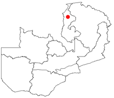
n province of Luapula
Luapula Province
Luapula Province is one of Zambia's nine provinces, and is located in the north of the country. The provincial capital is Mansa. Luapula Province was named after the Luapula River....
located on the edge of the northern Zambian plateau above the Luapula
Luapula River
The Luapula River is a section of Africa's second-longest river, the Congo. It is a transnational river forming for nearly all its length part of the border between Zambia and the DR Congo...
valley at an altitude of 1300 m. It was chosen as an administrative district of the same name by the British colonial authorities who preferred the climate of the plateau rather than the hotter valley where most of the district's population live, and it continues as an administrative district today.
Kawambwa sits at the junction of gravel roads to Nchelenge
Nchelenge
Nchelenge is a town in the Luapula Province of northern Zambia, lying on the south eastern shore of Lake Mweru. It is contiguous with Kashikishi, and they are sometimes referred to as Nchelenge-Kashikishi...
, Mporokoso
Mporokoso
Mporokoso is a town in the Northern Province of Zambia, lying at an elevation of nearly 1500 m on the flat plateau about 75 km south east of Lake Mweru Wantipa and 100 km south-west of Lake Tanganyika...
, Mushota and Mansa
Mansa, Zambia
Mansa is the capital of the Luapula Province of Zambia, and headquarters of Mansa District. It takes its name from the local Chief Mansa and the small Mansa River which flows west to the Luapula River...
, and a tarred road to Mbereshi
Mbereshi
Mbereshi is a village in the Luapula Province of Zambia, named after the Mbereshi River on its north side. It was the site of a large mission founded in 1900 by the London Missionary Society. In 1915 the mission established the first girls' school in the territory, as well as a boy's school and a...
linking with the Zambia Way, the main tarred highway of the Luapula Province through Kazembe (Mwansabombwe)
Kazembe (Mwansabombwe)
Kazembe is a name used for Mwata Kazembe's town in the Luapula Province of Zambia, especially on maps and in the Zambian postal service . However, the correct name for the town is Mwansabombwe and this is the one used by its or Luba or Chibemba-speaking inhabitants...
and Mansa.
Zambia's largest tea plantation is situated 27 km from Kawambwa on the Mporokoso road.
A camp for refugees of war in the eastern DR Congo was established by United Nations agencies at Kala 24 km north of Kawambwa in 1998, with a capacity for 40,000 refugees.
Near to Kawambwa are two of Zambia's most impressive waterfalls, the mighty Lumangwe Falls
Lumangwe Falls
Lumangwe Falls on the Kalungwishi River in northern Zambia is the largest waterfall wholly within that country, with a height of 30-40 m and a width of 160 m. The falls is 80 km from Mporokoso on the Kawambwa road...
50 km to the north-east on the Kalungwishi River
Kalungwishi River
The Kalungwishi River flows west in northern Zambia into Lake Mweru. It is known for its waterfalls, including the Lumangwe Falls, Kabweluma Falls, Kundabwiku Falls and Mumbuluma Falls....
and the beautiful Ntumbachushi Falls
Ntumbachushi Falls
Ntumbachushi Falls are situated on the Ngona River in Luapula Province, Zambia where it runs over the edge of the northern Zambian plateau into the valley of the Luapula River....
on the Ngona River, 16 km west.