
Kapa'au, Hawai'i
Encyclopedia
Kapaau is a census-designated place
(CDP) in Hawaii County
, Hawaii
, United States
, at the northern tip of the big island of Hawaii
. The population was 1,159 at the 2000 census. It is celebrated as the birthplace of Kamehameha I
.
District of Hawaii County.
According to the United States Census Bureau
, the CDP has a total area of 2.2 square miles (5.7 km²), all of it land.
of 2000, there were 1,159 people, 405 households, and 270 families residing in the CDP. The population density
was 536.1 people per square mile (207.2/km²). There were 443 housing units at an average density of 204.9 per square mile (79.2/km²). The racial makeup of the CDP was 23.47% White, 0.09% African American, 0.09% Native American, 27.44% Asian, 9.32% Pacific Islander, 1.73% from other races
, and 37.88% from two or more races. Hispanic or Latino of any race were 16.65% of the population.
There were 405 households out of which 28.6% had children under the age of 18 living with them, 50.6% were married couples
living together, 11.6% had a female householder with no husband present, and 33.3% were non-families. 26.2% of all households were made up of individuals and 17.3% had someone living alone who was 65 years of age or older. The average household size was 2.81 and the average family size was 3.48.
In the CDP the population was spread out with 27.1% under the age of 18, 7.0% from 18 to 24, 22.3% from 25 to 44, 24.4% from 45 to 64, and 19.2% who were 65 years of age or older. The median age was 40 years. For every 100 females there were 94.5 males. For every 100 females age 18 and over, there were 93.4 males.
The median income for a household in the CDP was $45,764, and the median income for a family was $50,703. Males had a median income of $30,694 versus $28,021 for females. The per capita income
for the CDP was $17,131. About 4.7% of families and 7.8% of the population were below the poverty line, including 9.8% of those under age 18 and 6.8% of those age 65 or over.
was cast in 1888, lost at sea, and then recovered and erected at Kapaau. His actual birthplace was a few miles away in the Kohala Historical Sites State Monument, a remote area not easily accessible. June 11 is the State holiday Kamehameha Day
, celebrated by a parade through the town.
The Kauhola Point Light
house is on the coast about three miles Northeast of the town.
Kohala High & Elementary School is also located in Kapaau, and serves students in grades K-12.
Census-designated place
A census-designated place is a concentration of population identified by the United States Census Bureau for statistical purposes. CDPs are delineated for each decennial census as the statistical counterparts of incorporated places such as cities, towns and villages...
(CDP) in Hawaii County
Hawaii County, Hawaii
Hawaii County is a county located in the U.S. state of Hawaii in the Hawaiian Islands. It is coterminous with the Island of Hawaii, often called the "Big Island" to distinguish it from the state as a whole. As of the 2010 Census the population was 185,079. The county seat is Hilo. There are no...
, Hawaii
Hawaii
Hawaii is the newest of the 50 U.S. states , and is the only U.S. state made up entirely of islands. It is the northernmost island group in Polynesia, occupying most of an archipelago in the central Pacific Ocean, southwest of the continental United States, southeast of Japan, and northeast of...
, United States
United States
The United States of America is a federal constitutional republic comprising fifty states and a federal district...
, at the northern tip of the big island of Hawaii
Hawaii (island)
The Island of Hawaii, also called the Big Island or Hawaii Island , is a volcanic island in the North Pacific Ocean...
. The population was 1,159 at the 2000 census. It is celebrated as the birthplace of Kamehameha I
Kamehameha I
Kamehameha I , also known as Kamehameha the Great, conquered the Hawaiian Islands and formally established the Kingdom of Hawaii in 1810. By developing alliances with the major Pacific colonial powers, Kamehameha preserved Hawaii's independence under his rule...
.
Geography
Kapaau is located at 20°14′5"N 155°48′23"W (20.234711, -155.806361) in the North KohalaKohala, Hawaii
thumb|right|300px|The districts of the [[Hawaii |Big Island]]. From Northernmost, clockwise; Kohala , [[Hamakua|Hāmākua]], [[Hilo, Hawaii|Hilo]], [[Puna, Hawaii|Puna]], [[Kau, Hawaii|Kaū]], [[Kona District, Hawaii|Kona]]...
District of Hawaii County.
According to the United States Census Bureau
United States Census Bureau
The United States Census Bureau is the government agency that is responsible for the United States Census. It also gathers other national demographic and economic data...
, the CDP has a total area of 2.2 square miles (5.7 km²), all of it land.
Demographics
As of the censusCensus
A census is the procedure of systematically acquiring and recording information about the members of a given population. It is a regularly occurring and official count of a particular population. The term is used mostly in connection with national population and housing censuses; other common...
of 2000, there were 1,159 people, 405 households, and 270 families residing in the CDP. The population density
Population density
Population density is a measurement of population per unit area or unit volume. It is frequently applied to living organisms, and particularly to humans...
was 536.1 people per square mile (207.2/km²). There were 443 housing units at an average density of 204.9 per square mile (79.2/km²). The racial makeup of the CDP was 23.47% White, 0.09% African American, 0.09% Native American, 27.44% Asian, 9.32% Pacific Islander, 1.73% from other races
Race (United States Census)
Race and ethnicity in the United States Census, as defined by the Federal Office of Management and Budget and the United States Census Bureau, are self-identification data items in which residents choose the race or races with which they most closely identify, and indicate whether or not they are...
, and 37.88% from two or more races. Hispanic or Latino of any race were 16.65% of the population.
There were 405 households out of which 28.6% had children under the age of 18 living with them, 50.6% were married couples
Marriage
Marriage is a social union or legal contract between people that creates kinship. It is an institution in which interpersonal relationships, usually intimate and sexual, are acknowledged in a variety of ways, depending on the culture or subculture in which it is found...
living together, 11.6% had a female householder with no husband present, and 33.3% were non-families. 26.2% of all households were made up of individuals and 17.3% had someone living alone who was 65 years of age or older. The average household size was 2.81 and the average family size was 3.48.
In the CDP the population was spread out with 27.1% under the age of 18, 7.0% from 18 to 24, 22.3% from 25 to 44, 24.4% from 45 to 64, and 19.2% who were 65 years of age or older. The median age was 40 years. For every 100 females there were 94.5 males. For every 100 females age 18 and over, there were 93.4 males.
The median income for a household in the CDP was $45,764, and the median income for a family was $50,703. Males had a median income of $30,694 versus $28,021 for females. The per capita income
Per capita income
Per capita income or income per person is a measure of mean income within an economic aggregate, such as a country or city. It is calculated by taking a measure of all sources of income in the aggregate and dividing it by the total population...
for the CDP was $17,131. About 4.7% of families and 7.8% of the population were below the poverty line, including 9.8% of those under age 18 and 6.8% of those age 65 or over.
Points of interest
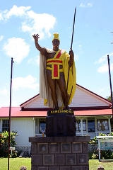
The King Kamehameha StatueKamehameha Statue
Several Kamehameha Statues honor the monarch who founded the Kingdom of Hawaii.-Gould's work:One stands prominently in front of Aliiolani Hale in Honolulu, Hawaii. The statue had its origins in 1878 when Walter M. Gibson, a member of the Hawaiian government at the time, wanted to commemorate the...
was cast in 1888, lost at sea, and then recovered and erected at Kapaau. His actual birthplace was a few miles away in the Kohala Historical Sites State Monument, a remote area not easily accessible. June 11 is the State holiday Kamehameha Day
Kamehameha Day
Kamehameha Day on June 11 is a public holiday of the state of Hawaii in the United States. It honors Kamehameha the Great, the monarch who first established the unified Kingdom of Hawaii — comprising the Hawaiian Islands of Niihau, Kauai, Oahu, Molokai, Lānai, Kahoolawe, Maui and...
, celebrated by a parade through the town.
The Kauhola Point Light
Kauhola Point Light
Kauhola Point Lighthouse is located near Kapa'au, on the 'Big Island' of Hawaii. It is near the northernmost tip of the island.On December 12, 2009, this structure was demolished due to erosion near its base.-External links:*...
house is on the coast about three miles Northeast of the town.
Kohala High & Elementary School is also located in Kapaau, and serves students in grades K-12.