Kahoolawe is the smallest of the eight main
volcanic2. Bedrock3. Conduit 4. Base5. Sill6. Dike7. Layers of ash emitted by the volcano8. Flank| 9. Layers of lava emitted by the volcano10. Throat11. Parasitic cone12. Lava flow13. Vent14. Crater15...
islands in the
Hawaiian IslandsThe Hawaiian Islands are an archipelago of eight major islands, several atolls, numerous smaller islets, and undersea seamounts in the North Pacific Ocean, extending some 1,500 miles from the island of Hawaii in the south to northernmost Kure Atoll...
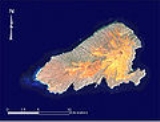
. Kahoolawe is located about seven miles (11.2 km) southwest of
MauiThe island of Maui is the second-largest of the Hawaiian Islands at and is the 17th largest island in the United States. Maui is part of the state of Hawaii and is the largest of Maui County's four islands, bigger than Lānai, Kahoolawe, and Molokai. In 2010, Maui had a population of 144,444,...
and also southeast of
LanaiLānai or Lanai is the sixth-largest of the Hawaiian Islands. It is also known as the Pineapple Island because of its past as an island-wide pineapple plantation. The only town is Lānai City, a small settlement....
, and it is 11 miles (17.7 km) long by 6 miles (9.7 km) wide, with a total land area of 44.6 square miles (115.5 km²). The highest point on Kahoolawe is the
craterA volcanic crater is a circular depression in the ground caused by volcanic activity. It is typically a basin, circular in form within which occurs a vent from which magma erupts as gases, lava, and ejecta. A crater can be of large dimensions, and sometimes of great depth...
of Lua Makika at the summit of Puu Moaulanui, which is about 1477 feet (450.2 m) above sea level. Kahoolawe is relatively dry (average annual rainfall is less than 65 cm (25.6 in)) because the island's low elevation fails to generate much
orographicOrographic lift occurs when an air mass is forced from a low elevation to a higher elevation as it moves over rising terrain. As the air mass gains altitude it quickly cools down adiabatically, which can raise the relative humidity to 100% and create clouds and, under the right conditions,...
precipitationIn meteorology, precipitation In meteorology, precipitation In meteorology, precipitation (also known as one of the classes of hydrometeors, which are atmospheric water phenomena is any product of the condensation of atmospheric water vapor that falls under gravity. The main forms of precipitation...
from the northeastern
trade windThe trade winds are the prevailing pattern of easterly surface winds found in the tropics, within the lower portion of the Earth's atmosphere, in the lower section of the troposphere near the Earth's equator...
s, and Kahoolawe is located in the
rain shadowA rain shadow is a dry area on the lee side of a mountainous area. The mountains block the passage of rain-producing weather systems, casting a "shadow" of dryness behind them. As shown by the diagram to the right, the warm moist air is "pulled" by the prevailing winds over a mountain...
of eastern Maui's 10023 feet (3,055 m) high volcano,
HaleakalāHaleakalā , or the East Maui Volcano, is a massive shield volcano that forms more than 75% of the Hawaiian Island of Maui. The western 25% of the island is formed by the West Maui Mountains.- History :...
. More than one quarter of Kahoolawe has been
erodedErosion is when materials are removed from the surface and changed into something else. It only works by hydraulic actions and transport of solids in the natural environment, and leads to the deposition of these materials elsewhere...
down to
saproliticSaprolite is a chemically weathered rock. Saprolites form in the lower zones of soil profiles and represent deep weathering of the bedrock surface. In most outcrops its color comes from ferric compounds...
hardpanIn soil science, agriculture and gardening, hardpan or ouklip is a general term for a dense layer of soil, usually found below the uppermost topsoil layer. There are different types of hardpan, all sharing the general characteristic of being a distinct soil layer that is largely impervious to water...
soil.
Kahoolawe has always been sparsely populated, due to its lack of
fresh waterFresh Water is the debut album by Australian rock and blues singer Alison McCallum, released in 1972. Rare for an Australian artist at the time, it came in a gatefold sleeve...
. During
World War IIWorld War II, or the Second World War , was a global conflict lasting from 1939 to 1945, involving most of the world's nations—including all of the great powers—eventually forming two opposing military alliances: the Allies and the Axis...
, Kahoolawe was used as a training ground and
bombing rangeA bombing range is an area used for testing explosive ordnance and practicing to accurately direct them to the target. Bombing ranges are used for munitions that either explode or produce too much destruction to use at a shooting range, such as kinetic energy penetrators or very large caliber...
by the
Armed Forces of the United StatesThe United States Armed Forces are the military forces of the United States. They consist of the Army, Navy, Marine Corps, Air Force, and Coast Guard.The United States has a strong tradition of civilian control of the military...
. After decades of protests, the U.S. Navy ended live-fire training exercises on Kahoolawe in 1990, and the whole island was transferred to the jurisdiction of the State of Hawaii in 1994. The Hawaii State Legislature established the
Kahoolawe Island Reserve to restore and to oversee the island and its surrounding waters. Today Kahoolawe can be used only for
native HawaiianNative Hawaiians refers to the indigenous Polynesian people of the Hawaiian Islands or their descendants. Native Hawaiians trace their ancestry back to the original Polynesian settlers of Hawaii.According to the U.S...
cultural, spiritual, and subsistence purposes.
The U.S. Census Bureau defines Kahoolawe as Block Group 9,
Census TractA census tract, census area, or census district is a geographic region defined for the purpose of taking a census. Usually these coincide with the limits of cities, towns or other administrative areas and several tracts commonly exist within a county...
303.02 of
Maui County, Hawaii-National protected areas:* Haleakala National Park* Kakahaia National Wildlife Refuge* Kealia Pond National Wildlife Refuge- Demographics :As of the 2000 Census, there were 128,094 people, 43,507 households, and 29,889 families residing in the county. The population density was 110 people per...
. Kahoolawe has no permanent residents.
Settlement
Sometime around the year 1000, Kahoolawe was settled, and small, temporary fishing communities were established along the coast. Some inland areas were cultivated. Puu Moiwi, a remnant
cinder coneAccording to the , Cinder Cone is the proper name of 1 cinder cone in Canada and 7 cinder cones in the United States:In Canada: Cinder Cone In the United States:...
, is the location of the second-largest
basaltBasalt is a common extrusive volcanic rock. It is usually grey to black and fine-grained due to rapid cooling of lava at the surface of a planet. It may be porphyritic containing larger crystals in a fine matrix, or vesicular, or frothy scoria. Unweathered basalt is black or grey...
quarryA quarry is a type of open-pit mine from which rock or minerals are extracted. Quarries are generally used for extracting building materials, such as dimension stone, construction aggregate, riprap, sand, and gravel. They are often collocated with concrete and asphalt plants due to the requirement...
in
HawaiiHawaii is the newest of the 50 U.S. states , and is the only U.S. state made up entirely of islands. It is the northernmost island group in Polynesia, occupying most of an archipelago in the central Pacific Ocean, southwest of the continental United States, southeast of Japan, and northeast of...
, and this was mined for use in
stone toolA stone tool is, in the most general sense, any tool made either partially or entirely out of stone. Although stone tool-dependent societies and cultures still exist today, most stone tools are associated with prehistoric, particularly Stone Age cultures that have become extinct...
s such as
koi (
adzeAn adze is a tool used for smoothing or carving rough-cut wood in hand woodworking. Generally, the user stands astride a board or log and swings the adze downwards towards his feet, chipping off pieces of wood, moving backwards as they go and leaving a relatively smooth surface behind...
s). Originally a
dry forestThe Hawaiian tropical dry forests are a tropical dry broadleaf forest ecoregion in the Hawaiian Islands. They cover an area of on the leeward side of the main islands and the summits of Niihau and Kahoolawe. These forests are either seasonal or sclerophyllous. Annual rainfall is less than and...
environment with intermittent streams, the land changed to an open
savannaThe Hawaiian tropical low shrublands are a tropical savanna ecoregion in the Hawaiian Islands. These shrublands cover an area of in the leeward lowlands of the main islands and most of the smaller islands, including the Northwestern Hawaiian Islands. The ecoregion includes both grasslands and...
of
grasslandGrasslands are areas where the vegetation is dominated by grasses and other herbaceous plants . However, sedge and rush families can also be found. Grasslands occur naturally on all continents except Antarctica...
and trees when inhabitants cleared vegetation for
firewoodFirewood is any wood-like material that is gathered and used for fuel. Generally, firewood is not highly processed and is in some sort of recognizable log or branch form....
and
agricultureAgriculture is the cultivation of animals, plants, fungi and other life forms for food, fiber, and other products used to sustain life. Agriculture was the key implement in the rise of sedentary human civilization, whereby farming of domesticated species created food surpluses that nurtured the...
. Hawaiians built stone platforms for
religiousHawaiian religion is the term used to describe the folk religious beliefs and practises of the Hawaiian people. It is unrelated to, though commonly confused with, the philosophy of Huna....
ceremonies, set rocks upright as shrines for successful fishing trips, and carved
petroglyphPetroglyphs are pictogram and logogram images created by removing part of a rock surface by incising, picking, carving, and abrading. Outside North America, scholars often use terms such as "carving", "engraving", or other descriptions of the technique to refer to such images...
s, or drawings, into the flat surfaces of rocks. These indicators of an earlier time can still be found on Kahoolawe.
While it is not known how many people inhabited Kahoolawe, the lack of
freshwaterFresh water is naturally occurring water on the Earth's surface in ice sheets, ice caps, glaciers, bogs, ponds, lakes, rivers and streams, and underground as groundwater in aquifers and underground streams. Fresh water is generally characterized by having low concentrations of dissolved salts and...
probably limited the population to a few hundred people. As many as 120 people might have once lived at Hakioawa, the largest settlement, which was located at the northeastern end of the island -- facing Maui.
Warfare
Violent wars among competing
aliiAlii is a word in the Polynesian language denoting chiefly status in ancient Hawaii and the Samoa Islands. A similar word with the same concept is found in other Polynesian societies. In the Cook Islands, an ariki is a high chief and the House of Ariki is a parliamentary house...
(chiefs) laid waste to the land and led to a decline in the population. During the War of Kamokuhi, Kalaniōpuu, the
rulerThe following is a list of alii aimoku of Hawaii. "Alii aimoku" refers to the ruler of the island. alii refers to the ruling class of ancient Hawaii...
of the
Big Island of HawaiiThe Island of Hawaii, also called the Big Island or Hawaii Island , is a volcanic island in the North Pacific Ocean...
, raided and pillaged Kahoolawe in an unsuccessful attempt to take Maui from
Kahekili IIKahekili II, full name Kahekilinuiahumanu, was the twenty fifth King of Maui. His name was short for Kāne-Hekili after the Hawaiian god of thunder. Because Kāne-Hekili was believed to be black on one side, Kahekili tattooed one side of his body from head to foot.-Family:He was born about...
, the King of Maui.
Post-contact
From 1778 to the early 19th century, observers on passing ships reported that Kahoolawe was uninhabited and barren, destitute of both water and wood. After the arrival of
missionariesThe American Board of Commissioners for Foreign Missions was the first American Christian foreign mission agency. It was proposed in 1810 by recent graduates of Williams College and officially chartered in 1812. In 1961 it merged with other societies to form the United Church Board for World...
from
New EnglandNew England is a region in the northeastern corner of the United States consisting of the six states of Maine, New Hampshire, Vermont, Massachusetts, Rhode Island, and Connecticut...
, the
Kingdom of HawaiiThe Kingdom of Hawaii was established during the years 1795 to 1810 with the subjugation of the smaller independent chiefdoms of Oahu, Maui, Molokai, Lānai, Kauai and Niihau by the chiefdom of Hawaii into one unified government...
under the rule of King
Kamehameha IIIKamehameha III was the King of Hawaii from 1825 to 1854. His full Hawaiian name was Keaweaweula Kiwalao Kauikeaouli Kaleiopapa and then lengthened to Keaweaweula Kiwalao Kauikeaouli Kaleiopapa Kalani Waiakua Kalanikau Iokikilo Kiwalao i ke kapu Kamehameha when he ascended the throne.Under his...
replaced the death penalty with exile, and Kahoolawe became a men's
penal colonyA penal colony is a settlement used to exile prisoners and separate them from the general populace by placing them in a remote location, often an island or distant colonial territory...
sometime around 1830. Food and water were scarce, some prisoners reportedly starved, and some of them swam across the channel to Maui to find food. The law making the island a penal colony was repealed in 1853.
A survey of Kahoolawe in 1857 reported about 50 residents here, about 5000 acres (20.2 km²) of land covered with
shrubA shrub or bush is distinguished from a tree by its multiple stems and shorter height, usually under 5–6 m tall. A large number of plants may become either shrubs or trees, depending on the growing conditions they experience...
s, and a patch of
sugarcaneSugarcane refers to any of six to 37 species of tall perennial grasses of the genus Saccharum . Native to the warm temperate to tropical regions of South Asia, they have stout, jointed, fibrous stalks that are rich in sugar, and measure two to six metres tall...
growth. Along the shore,
tobaccoTobacco is an agricultural product processed from the leaves of plants in the genus Nicotiana. It can be consumed, used as a pesticide and, in the form of nicotine tartrate, used in some medicines...
,
pineapplePineapple is the common name for a tropical plant and its edible fruit, which is actually a multiple fruit consisting of coalesced berries. It was given the name pineapple due to its resemblance to a pine cone. The pineapple is by far the most economically important plant in the Bromeliaceae...
,
gourdA gourd is a plant of the family Cucurbitaceae. Gourd is occasionally used to describe crops like cucumbers, squash, luffas, and melons. The term 'gourd' however, can more specifically, refer to the plants of the two Cucurbitaceae genera Lagenaria and Cucurbita or also to their hollow dried out shell...
s,
pili grassHeteropogon contortus is a tropical, perennial tussock grass with a native distribution encompassing Southern Africa, southern Asia, Northern Australia and Oceania. The species has also become a naturalised weed in tropical and subtropical regions in the Americas and East Asia. The plant grows to ...
, and scrub trees grew. Beginning in 1858, the Hawaiian government leased Kahoolawe to a series of
ranchA ranch is an area of landscape, including various structures, given primarily to the practice of ranching, the practice of raising grazing livestock such as cattle or sheep for meat or wool. The word most often applies to livestock-raising operations in the western United States and Canada, though...
ing ventures. Some of these proved to be more successful than others, but the lack of freshwater was an unrelenting enemy. Through the next 80 years, the landscape changed dramatically, with
droughtA drought is an extended period of months or years when a region notes a deficiency in its water supply. Generally, this occurs when a region receives consistently below average precipitation. It can have a substantial impact on the ecosystem and agriculture of the affected region...
and uncontrolled
overgrazingOvergrazing occurs when plants are exposed to intensive grazing for extended periods of time, or without sufficient recovery periods. It can be caused by either livestock in poorly managed agricultural applications, or by overpopulations of native or non-native wild animals.Overgrazing reduces the...
denuded much of the island. Strong
trade windThe trade winds are the prevailing pattern of easterly surface winds found in the tropics, within the lower portion of the Earth's atmosphere, in the lower section of the troposphere near the Earth's equator...
s blew away most of the
topsoilTopsoil is the upper, outermost layer of soil, usually the top to . It has the highest concentration of organic matter and microorganisms and is where most of the Earth's biological soil activity occurs.-Importance:...
, leaving behind red
hardpanIn soil science, agriculture and gardening, hardpan or ouklip is a general term for a dense layer of soil, usually found below the uppermost topsoil layer. There are different types of hardpan, all sharing the general characteristic of being a distinct soil layer that is largely impervious to water...
dirt.
20th century
From 1910 to 1918, the
Territory of HawaiiThe Territory of Hawaii or Hawaii Territory was an organized incorporated territory of the United States that existed from July 7, 1898, until August 21, 1959, when its territory, with the exception of Johnston Atoll, was admitted to the Union as the fiftieth U.S. state, the State of Hawaii.The U.S...
designated Kahoolawe as a
forest reserveA nature reserve is a protected area of importance for wildlife, flora, fauna or features of geological or other special interest, which is reserved and managed for conservation and to provide special opportunities for study or research...
in the hope of restoring the island through a
revegetationRevegetation is the process of replanting and rebuilding the soil of disturbed land. This may be a natural process produced by plant colonization and succession, or an artificial , accelerated process designed to repair damage to a landscape due to wildfire, mining, flood, or other cause...
and livestock removal program. This program failed, and leases again became available. In 1918, the rancher Angus MacPhee of Whoming, with the help of the landowner Harry Baldwin of Maui, leased the island for 21 years, intending to build a
cattleCattle are the most common type of large domesticated ungulates. They are a prominent modern member of the subfamily Bovinae, are the most widespread species of the genus Bos, and are most commonly classified collectively as Bos primigenius...
ranch there. By 1932, the ranching operation was enjoying moderate success. After heavy rains, native grasses and flowering plants would sprout, but droughts always returned. In 1941, MacPhee sublet part of the island to the U.S. Army. Later that year, because of continuing drought, MacPhee removed his cattle from the island.
Training grounds
On December 8, 1941, after the
Imperial Japanese NavyThe Imperial Japanese Navy was the navy of the Empire of Japan from 1869 until 1947, when it was dissolved following Japan's constitutional renunciation of the use of force as a means of settling international disputes...
attacked Pearl Harbor and OahuThe attack on Pearl Harbor was a surprise military strike conducted by the Imperial Japanese Navy against the United States naval base at Pearl Harbor, Hawaii, on the morning of December 7, 1941...
, the U.S. Army declared
martial lawMartial law is the imposition of military rule by military authorities over designated regions on an emergency basis— only temporary—when the civilian government or civilian authorities fail to function effectively , when there are extensive riots and protests, or when the disobedience of the law...
throughout Hawaii, and it used Kahoolawe as a place to train American soldiers and Marines headed west to engage in the
War in the PacificWar in the Pacific is a 2004 two-player turn-based computer war game published by Matrix games. It is a very large, complex, and detailed simulation of the Pacific Theatre of World War II, at both the operational and strategic level....
. The use of Kahoolawe as a
bombing rangeA bombing range is an area used for testing explosive ordnance and practicing to accurately direct them to the target. Bombing ranges are used for munitions that either explode or produce too much destruction to use at a shooting range, such as kinetic energy penetrators or very large caliber...
was believed to be critical, since the United States was executing a new type of war in the Pacific Islands. Their success depended on accurate
naval gunfire supportNaval gunfire support is the use of naval artillery to provide fire support for amphibious assault and other troops operating within their range. NGFS is one of a number of disciplines encompassed by the term Naval Fires...
that suppressed or destroyed enemy positions as U.S. Marines and soldiers struggled to get ashore. Thousands of soldiers, sailors, Marines, airmen, and coastguardsmen prepared on Kahoolawe for the brutal and costly assaults on islands such as the
Gilbert and Marshall IslandsIn the Pacific Theater of World War II, the Gilbert and Marshall Islands campaign, from November 1943 through February 1944, were key strategic operations of the United States Pacific Fleet and Marine Corps in the Central Pacific. The campaign was preceded by a raid on Makin Island by U.S...
, the
Marianas and PelileuThe Mariana and Palau Islands campaign, also known as Operation Forager, was an offensive launched by United States forces against Imperial Japanese forces in the Mariana Islands and Palau in the Pacific Ocean between June and November, 1944 during the Pacific War...
,
New GuineaNew Guinea is the world's second largest island, after Greenland, covering a land area of 786,000 km2. Located in the southwest Pacific Ocean, it lies geographically to the east of the Malay Archipelago, with which it is sometimes included as part of a greater Indo-Australian Archipelago...
, et cetera, in the Western Pacific.
Military and naval training on Kahoolawe continued following World War II. During the
Korean WarThe Korean War was a conventional war between South Korea, supported by the United Nations, and North Korea, supported by the People's Republic of China , with military material aid from the Soviet Union...
, warplanes from
aircraft carrierAn aircraft carrier is a warship designed with a primary mission of deploying and recovering aircraft, acting as a seagoing airbase. Aircraft carriers thus allow a naval force to project air power worldwide without having to depend on local bases for staging aircraft operations...
s played a critical role in attacking enemy airfields, convoys, and troop staging areas. Mock-ups of airfields, military camps, and vehicles were constructed on Kahoolawe, and while pilots were preparing for war at Barbers Point Naval Air Station on
OahuOahu or Oahu , known as "The Gathering Place", is the third largest of the Hawaiian Islands and most populous of the islands in the U.S. state of Hawaii. The state capital Honolulu is located on the southeast coast...
, they practiced spotting and hitting the mock-ups at Kahoolawe. Similar training took place throughout the
Cold WarThe Cold War was the continuing state from roughly 1946 to 1991 of political conflict, military tension, proxy wars, and economic competition between the Communist World—primarily the Soviet Union and its satellite states and allies—and the powers of the Western world, primarily the United States...
and during the War in Vietnam, with mock-ups of aircraft,
radarRadar is an object-detection system which uses radio waves to determine the range, altitude, direction, or speed of objects. It can be used to detect aircraft, ships, spacecraft, guided missiles, motor vehicles, weather formations, and terrain. The radar dish or antenna transmits pulses of radio...
installations, gun mounts, and
surface-to-air missileA surface-to-air missile or ground-to-air missile is a missile designed to be launched from the ground to destroy aircraft or other missiles...
sites being placed across this island for
pilotAn aviator is a person who flies an aircraft. The first recorded use of the term was in 1887, as a variation of 'aviation', from the Latin avis , coined in 1863 by G. de la Landelle in Aviation Ou Navigation Aérienne...
s and
bombardierA bombardier , in the United States Army Air Forces and United States Air Force, or a bomb aimer, in the Royal Air Force and other Commonwealth air forces, was the crewman of a bomber responsible for assisting the navigator in guiding the plane to a bombing target and releasing the aircraft's bomb...
s to use in their training.
In early 1965, the U.S. Navy conducted
Operation Sailor HatOperation Sailor Hat was an explosives effects test conducted by the United States Navy on the island of Kahoolawe, Hawaii in 1965. As they were not nuclear tests, they instead employed conventional explosives to simulate the effects of a nuclear weapon blast...
to determine the blast resistance of ships. Three tests off the coast of Kahoolawe subjected the island and a target ship to massive explosions, with 500
tonsTNT equivalent is a method of quantifying the energy released in explosions. The ton of TNT is a unit of energy equal to 4.184 gigajoules, which is approximately the amount of energy released in the detonation of one ton of TNT...
of conventional
TNT detonated on the island near the target ship . This
warshipA warship is a ship that is built and primarily intended for combat. Warships are usually built in a completely different way from merchant ships. As well as being armed, warships are designed to withstand damage and are usually faster and more maneuvrable than merchant ships...
was damaged, but she was not sunk. The blasts created a crater on the island known as "Sailor Man's Cap" and they might have cracked the island's
caprockThe Caprock is a region in the Panhandle of Texas . It is the land to the west of the Caprock Escarpment, which separates it from plains stretching to the east at a much lower elevation....
, causing some
groundwaterGroundwater is water located beneath the ground surface in soil pore spaces and in the fractures of rock formations. A unit of rock or an unconsolidated deposit is called an aquifer when it can yield a usable quantity of water. The depth at which soil pore spaces or fractures and voids in rock...
to be lost into the ocean.
Operation Protect Kahoolawe Ohana (PKO)
In 1976, a group of individuals calling themselves the Protect Kahoolawe Ohana (PKO) filed suit in U.S. Federal Court to stop the Navy's use of Kahoolawe for bombardment training, to require compliance with a number of new environmental laws and to ensure protection of cultural resources on the island. In 1977, the U.S. District Court for the District of Hawaii allowed the Navy's use of this island to continue, but the Court directed the Navy to prepare an
environmental impact statementAn environmental impact statement , under United States environmental law, is a document required by the National Environmental Policy Act for certain actions "significantly affecting the quality of the human environment". An EIS is a tool for decision making...
and to complete an inventory of historic sites on the island. On March 9, 1977, two PKO leaders,
George HelmGeorge Jarrett Helm, Jr. was a Native Hawaiian activist and musician from Kalamaula, Molokai, Hawaii. He graduated from St. Louis High School on Oahu, about which he said, "I came to Oahu to get educated. Instead I lost my innocence." While at St...
and Kimo Mitchell, were lost at sea during an attempt to occupy Kahoolawe in symbolic protest. In 1980, the Navy and the Protect Kahoolawe Ohana promulgated a
consent decreeA consent decree is a final, binding judicial decree or judgment memorializing a voluntary agreement between parties to a suit in return for withdrawal of a criminal charge or an end to a civil litigation...
that allowed continued naval training on the island, monthly access to the island for the PKO, surface clearance of part of the island (10000 acres (40.5 km²)),
soil conservationSoil conservation is a set of management strategies for prevention of soil being eroded from the Earth’s surface or becoming chemically altered by overuse, acidification, salinization or other chemical soil contamination...
, the eradication of
feral goatThe feral goat is the domestic goat when it has become established in the wild. Feral goats occur in Australia, New Zealand, Ireland, Great Britain, Hawaii, the Galapagos and in many other parts of the world...
s and an archaeological survey.
Kahoolawe Island Archeological District
On March 18, 1981, the entire island of Kahoolawe was added to the
National Register of Historic PlacesThe National Register of Historic Places is the United States government's official list of districts, sites, buildings, structures, and objects deemed worthy of preservation...
. At that time, the Kahoolawe Archaeological District was noted to contain 544 recorded archaeological or historic sites and over 2,000 individual features. As part of the soil conservation efforts, Mike Ruppe and other workers laid lines of explosives, detonating them to break the hardpan so that seedling trees could be planted. Used car tires were taken to Kahoolawe and placed in miles of deep gullies to slow the washing of red soil from the barren uplands to the surrounding shores. Ordinance and scrap metal was picked up by hand and then transported by large trucks to a collection site.
End of live-fire training
In 1990,
PresidentThe President of the United States of America is the head of state and head of government of the United States. The president leads the executive branch of the federal government and is the commander-in-chief of the United States Armed Forces....
George H. W. BushGeorge Herbert Walker Bush is an American politician who served as the 41st President of the United States . He had previously served as the 43rd Vice President of the United States , a congressman, an ambassador, and Director of Central Intelligence.Bush was born in Milton, Massachusetts, to...
ordered an end to live-fire training on the island. The U.S. Department of Defense
Appropriations ActAn appropriation bill or running bill is a legislative motion which authorizes the government to spend money. It is a bill that sets money aside for specific spending...
for Fiscal Year 1991 established the Kahoolawe Island Conveyance Commission to recommend terms and conditions for the conveyance of Kahoolawe from the U.S. Government to the Hawaii.
Transfer of title and UXO cleanup
In 1993, Senator
Daniel InouyeDaniel Ken "Dan" Inouye is the senior United States Senator from Hawaii, a member of the Democratic Party, and the President pro tempore of the United States Senate making him the highest-ranking Asian American politician in American history. Inouye is the chairman of the United States Senate...
of Hawaii sponsored Title X of the Fiscal Year 1994 for the Department of Defense
appropriation billAn appropriation bill or running bill is a legislative motion which authorizes the government to spend money. It is a bill that sets money aside for specific spending...
, directing that the U.S. Government to convey Kahoolawe and its surrounding waters to the State of Hawaii. Title X also established the objective of a "clearance or removal of
unexploded ordnanceUnexploded ordnance are explosive weapons that did not explode when they were employed and still pose a risk of detonation, potentially many decades after they were used or discarded.While "UXO" is widely and informally used, munitions and explosives of...
(UXO)" and the environmental restoration of the island, to provide "meaningful safe use of the island for appropriate cultural, historical, archaeological, and educational purposes, as determined by the State of Hawaii." In turn, the Legislature of Hawaii created the Kahoolawe Island Reserve Commission to exercise policy and management oversight of the Kahoolawe Island Reserve. As directed by Title X and in accordance with a required Memorandum of Understanding between the U.S. Navy and the State of Hawaii, the Navy transferred the title to the land of Kahoolawe to the Hawaii on May 9, 1994.
As required by Title X, the U.S. Navy retained access control to the island until the clearance and environmental restoration projects were completed, or until November 11, 2003, whichever came first. The State agreed to prepare a Use Plan for Kahoolawe and the Navy agreed to develop a Cleanup Plan based on that use plan and to implement that plan to the extent Congress provided funds for that purpose.
In July 1997, the Navy awarded a contract to the Parsons / UXB Joint Venture to clear unexploded ordinance from the island to the extent funds were provided by Congress. After the State and public review of the Navy cleanup plan, Parsons/UXB began their work on the island in November 1998.
From 1998 to 2003, the U.S. Navy, executed a large-scale, but limited, removal of unexploded ordnance and other environmental hazards from Kahoolawe. Since the clearance did not completely remove all the hazardous and dangerous materials from the island, a residual level of danger remains. The Kahoolawe Island Reserve Commission developed a plan to manage the residual risk to reserve users and to carry out a safety program, and to establish stewardship organizations to work in conjunction with the commission.
Kahoolawe Island Reserve
In 1993, the
Hawaiian State LegislatureHawaii is the newest of the 50 U.S. states , and is the only U.S. state made up entirely of islands. It is the northernmost island group in Polynesia, occupying most of an archipelago in the central Pacific Ocean, southwest of the continental United States, southeast of Japan, and northeast of...
established the
Kahoolawe Island Reserve, consisting of "the entire island and its surrounding ocean waters in a two mile (three km) radius from the shore". By State Law, Kahoolawe and its waters can only be used for Native Hawaiian cultural, spiritual, and subsistence purposes; fishing;
environmental restorationEnvironmental restoration is a term common in the citizens’ environmental movement. Environmental restoration is closely allied with ecological restoration or environmental remediation...
; historic preservation; and education. All commercial uses are prohibited.
The Legislature also created the
Kahoolawe Island Reserve Commission to manage the Reserve while it is held in trust for a future Native Hawaiian Sovereignty entity. The restoration of Kahoolawe will require a strategy to control
erosionErosion is when materials are removed from the surface and changed into something else. It only works by hydraulic actions and transport of solids in the natural environment, and leads to the deposition of these materials elsewhere...
, re-establish vegetation, recharge the
water tableThe water table is the level at which the submarine pressure is far from atmospheric pressure. It may be conveniently visualized as the 'surface' of the subsurface materials that are saturated with groundwater in a given vicinity. However, saturated conditions may extend above the water table as...
, and gradually replace alien plants with native species. Plans will include methods for
damA dam is a barrier that impounds water or underground streams. Dams generally serve the primary purpose of retaining water, while other structures such as floodgates or levees are used to manage or prevent water flow into specific land regions. Hydropower and pumped-storage hydroelectricity are...
ming gullies and reducing rainwater
runoffSurface runoff is the water flow that occurs when soil is infiltrated to full capacity and excess water from rain, meltwater, or other sources flows over the land. This is a major component of the water cycle. Runoff that occurs on surfaces before reaching a channel is also called a nonpoint source...
. In some areas, non-native plants will temporarily stabilize soils before planting of permanent native species. Species used for revegetation include
aalii (
Dodonaea viscosaDodonaea viscosa is a species of flowering plant in the soapberry family, Sapindaceae, that has a cosmopolitan distribution in tropical, subtropical and warm temperate regions of Africa, the Americas, southern Asia and Australasia.-Description:...
),
āheahea (
ChenopodiumChenopodium is a genus of about 150 species of perennial or annual herbaceous flowering plants known as the goosefoots, which occur almost anywhere in the world. It is placed in the family Amaranthaceae in the APG II system; older classifications separate it and its relatives as Chenopodiaceae, but...
oahuense),
kuluī (
NototrichiumNototrichium is a genus of flowering plants in the pigweed family, Amaranthaceae. All members of the genus are endemic to the Hawaiian Islands. They are known in Hawaiian as kuluī.-Species:*Nototrichium divaricatum Lorence...
sandwicense),
Achyranthes splendensAchyranthes splendens is a species of flowering plant in the pigweed family, Amaranthaceae, that is endemic to Hawaii. Its natural habitats are dry forests, low shrublands, and sandy shores...
,
ūlei (
Osteomeles anthyllidifoliaOsteomeles anthyllidifolia, commonly called Ūlei, Eluehe, Uulei, Hawaiian Rose, or Hawaiian Hawthorn, is a species of flowering shrub in the rose family, Rosaceae, that is indigenous to Hawaii , the Cook Islands, Tonga, Rarotonga, Pitcairn Island, and Rapa Iti.-Description:Osteomeles...
),
kāmanomano (
Cenchrus agrimonioides var. agrimonioidesCenchrus agrimonioides is a rare species of grass in the Poaceae family that is endemic to the Hawaiian Islands. Its common names include Kāmanomano and agrimony sandbur. It was formerly distributed throughout the major islands but today it is nearly limited to Oahu. Kāmanomano inhabits dry to...
),
koaia (
Acacia koaiaAcacia koaia, known as koaia or koaie in Hawaiian, is a tree in the pea family, Fabaceae, that is endemic to Hawaii. It is closely related to koa , and is sometimes considered to be the same species...
), and
alahee (
Psydrax odorataPsydrax odorata, known as Alahee in Hawaiian, is a species of flowering shrub or small tree in the coffee family, Rubiaceae, that is native to the Pacific Islands, Malesia and Australasia...
).
Traditional subdivisions
Traditionally, Kahoolawe has been an
ahupua'aIn old Hawaii, ahupuaa was the common subdivision of the land. It is comparable to the tapere in the Southern Cook Islands. The traditional subdivision has four hierarchical levels:*mokupuni *moku...
of Honua'ula (Makawao), one of the twelve
moku of the island (
mokupuni) of Maui., and was subdivided into twelve
`ili that were later combined to eight: The eight ''ʻili
are listed below, in counterclockwise sequence, and original area figures in acreThe acre is a unit of area in a number of different systems, including the imperial and U.S. customary systems. The most commonly used acres today are the international acre and, in the United States, the survey acre. The most common use of the acre is to measure tracts of land.The acre is related...
s, starting in the northeast:
| Nr. |
''ʻili |
Area acreThe acre is a unit of area in a number of different systems, including the imperial and U.S. customary systems. The most commonly used acres today are the international acre and, in the United States, the survey acre. The most common use of the acre is to measure tracts of land.The acre is related... s |
Area km² |
| 1 |
Hakioawa |
2283 |
9.24 |
| 2 |
Pāpākā |
1443 |
5.84 |
| 3 |
Kuheia-Kaulana |
3429 |
13.88 |
| 4 |
Ahupū |
4351 |
17.61 |
| 5 |
Honoko`a |
1701 |
6.88 |
| 6 |
Kealaikahiki |
3276 |
13.26 |
| 7 |
Kūnaka-Na`alapa |
9626 |
38.96 |
| 8 |
Kanapou |
2511 |
10.16 |
| 9 |
(Lua Makika) |
156 |
0.63 |
| |
Kahoʻolawe |
28776 |
116.45 |
The boundaries of all but the two westernmost `ili converge on the crater rim of Lua Makika, but do not include it. The crater area of Lua Makika is not considered an `ili and does not belong to any `ili.
According to other sources, the island was subdivided into 16 ahupua'a that belonged to three moku, namely Kona, Ko’olau and Molokini.
See also
- Alalakeiki Channel
- National Register of Historic Places listings in Hawaii#Kahoolawe
- Vieques, Puerto Rico
Vieques , in full Isla de Vieques, is an island–municipality of Puerto Rico in the northeastern Caribbean, part of an island grouping sometimes known as the Spanish Virgin Islands...
Further reading
Ai Pohaku Press
| year = 1995
| isbn = 1883528011
}}
}}olawe
| journal = Honolulu Magazine-History:In 1888, when Hawaii was still a monarchy, King Kalākaua commissioned a magazine under royal charter to be Hawaii's ambassador to the world. That magazine was Paradise of the Pacific. For nearly a century, Paradise of the Pacific promoted local business and tourism by assuring citizens of...
| publisher = PacificBasin Communications
| month = November
| year = 2006
| url = http://www.honolulumagazine.com/Honolulu-Magazine/November-2006/On-Kaho-8216olawe/
}}o Aloha O Kahoolawe
| publisher = Aloha Aina O Na Kupuna, Inc.
| location = Honolulu
| year = 1978
| isbn =
}}
External links