

Jave la Grande
Encyclopedia
Marco Polo
Marco Polo was a Venetian merchant traveler from the Venetian Republic whose travels are recorded in Il Milione, a book which did much to introduce Europeans to Central Asia and China. He learned about trading whilst his father and uncle, Niccolò and Maffeo, travelled through Asia and apparently...
, the largest island in the world: his Java Minor was the actual island of Sumatra
Sumatra
Sumatra is an island in western Indonesia, westernmost of the Sunda Islands. It is the largest island entirely in Indonesia , and the sixth largest island in the world at 473,481 km2 with a population of 50,365,538...
, which takes its name from the city of Samudera (now Lhokseumawe
Lhokseumawe
Lhokseumawe is the second largest city in Aceh province, Indonesia. It faces the Malacca Strait, and is surrounded by North Aceh Regency . The city covers an area of 212 square kilometres. According to the 2000 census Lhokseumawe had a population of 188,974 people...
) situated on its northern coast.
Earliest account
Due to a scribal error in Book III of Marco Polo’s travelsThe Travels of Marco Polo
Books of the Marvels of the World or Description of the World , also nicknamed Il Milione or Oriente Poliano and commonly called The Travels of Marco Polo, is a 13th-century travelogue written down by Rustichello da Pisa from stories told by Marco Polo, describing the...
treating of the route southward from Champa
Champa
The kingdom of Champa was an Indianized kingdom that controlled what is now southern and central Vietnam from approximately the 7th century through to 1832.The Cham people are remnants...
, where the name Java was substituted for Champa as the point of departure, Java Minor was located 1,300 miles to the south of Java Major, instead of from Champa, on or near an extension of the Terra Australis
Terra Australis
Terra Australis, Terra Australis Ignota or Terra Australis Incognita was a hypothesized continent appearing on European maps from the 15th to the 18th century...
.
As explained by Sir Henry Yule, the editor of an English edition of Marco Polo’s travels: “Some geographers of the 16th century, following the old editions which carried the travellers south-east of Java to the land of Boeach (or Locac), introduced in their maps a continent in that situation”.
Jean Alfonse's cosmography
Java Minor was identified as an island (the present Island of Java) by the Franco-Portuguese navigator and cosmographer Jean AlfonseJean Alfonse
Jean Fonteneau dit Alfonse de Saintonge was a French navigator, explorer and corsair, prominent in the European age of discovery....
in his work of 1544, La Cosmographie but Java Major according to him was part of the continent of Terra Australis, which extended as far as the Antarctic Pole and the Strait of Magellan. In La Cosmographie, Alfonse defined La Grande Jave as an extension of the giant Antarctic continent, or Terra Australis: “This Java touches the Straight of Magellan in the west, and in the east Terra Australis… I estimate that the coast of the Ocean Sea called the Austral coast extends eastwards to Java, to the western coast of the said Java.” Apparently in deference to Marco Polo’s claim that Java Major was the largest island in the world, Alfonse gave the name Jave Mynore to the island of Java and the name La Grand Jave to the continental land to the south. Marco Polo’s Java Minor, he called Samatrez (Sumatra). In La Cosmographie (1544), Alfonse said:
La Grand Jave is a land that goes as far as under the Antarctic Pole and from the Terre Australle in the west to the land of the Strait of Magellan on the eastern side. Some say that it is islands but from what I have seen of it, it is terre ferme [a continent]…That called Jave Mynore is an island, but la Grand Jave is terre ferme.
Later cartography
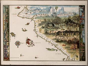
This cosmographical concept was exhibited in the mid-sixteenth century mappemondes of the School of mapmakers centred at DieppeDieppe maps
The Dieppe maps are a series of world maps produced in Dieppe, France, in the 1540s, 1550s and 1560s. They are large hand-produced maps, commissioned for wealthy and royal patrons, including Henry II of France and Henry VIII of England...
, Normandy, which in later times gave rise to the idea that Australia may have been discovered by Europeans long before the Dutch began to chart its coast in 1606 or before James Cook charted its east coast in 1770. This is seen clearly in Jean Rotz’s Lande of Java of 1542, and in Pierre Desceliers
Pierre Desceliers
Pierre Desceliers was a French cartographer of the Renaissance and an eminent member of the Dieppe School of Cartography. He is considered the father of French hydrography....
' mappemonde of 1546. Alfonse’s map of La Grande Jave bears a striking resemblance to that of Rotz.
Vincenzo Coronelli, on his Terrestrial Globe made in Venice in 1688, referred to the uncertainty regarding the location of Marco Polo’s Java Minor, noting that while in the opinion of some it could be identified with Sumatra, others believed it to be Sumbawa or New Holland. His inscription reads: “Various are the opinions of the Geographers concerning the location of Giava minore, some placing it under the Tropic of Capricorn, in accordance with what Marco Polo wrote in bk.3, cap.13. Others believe it to be Sumatra from the distance which the same Polo assigned to it, others take it for the Island of Sumbawa, and some others, more modern, for New Holland. We, from so much variety of opinion, do not offer a final conclusion on the matter, leaving the dispute undecided.”
In accordance with the uncorrected editions of Marco Polo’s travels, on his 1688 Terrestrial Globe Coronelli inscribed over the northern part of Nuova Hollandia: “Some believe that in this place M. Polo discovered the Land of Lochac, and that 500 miles further on is found the Island of Pentan, and the Kingdom of Malaiur.” As a result of this mis-placement southwards of the lands and islands described by Marco Polo, Coronelli and others confused Java Minor, Polo's name for Sumatra, with New Holland (Australia). This confusion was greater on the earlier Dieppe maps of the 1540s where Java Minor and Java Major (Jave la Grande) were transposed, apparently in accordance with Marco Polo's statement that Java Major was "the greatest island in the world". In the Dieppe maps, Jave la Grande was made a part of the antarctice continent, Terra Australis.
Marco Polo's placenames
Lochac (or Locach) was Marco Polo’s rendition of the Chinese (Cantonese) Lo-huk, which was how they referred to the southern Thai kingdom of Louvo (from Sanskrit Lavo, the present LopburiLopburi
Lopburi ) is the capital city of Lopburi Province in Thailand. It is located about 150 km north-east of Bangkok. As of 2006 it has a population of 26,500...
“city of Lavo”, after Lavo, in Hindu mythology the son of Rama: Lavo in Thai is spelled Lab, pronounced Lop’h; hence the name Lop’haburī, or Lop’ha-purī (Lopburi)). Louvo was united with Siam in 1350.
Beach, as a mistranscription of Locach, originated with the 1532 editions of the Novus Orbis Regionum by Simon Grynaeus and Johann Huttich, in which Marco Polo’s Locach was changed to Boëach, which was later shortened to Beach.
Pentan is the island of Bintan, and Malaiur was the old Tamil name for the Sumatran city of Jambi (and is the origin of the national name Malay).
Jave la Grande as a composite of Regio Patalis and Brasielie Regio
Robert J. King has suggested that Alfonse’s description of La Grande Jave could also fit the Regio Patalis promontory on Oronce Fine’s world map, and indicates that the Dieppe Maps appear to have conflated Marco Polo’s Greater Java with Fine’s Regio PatalisRegio Patalis
Regio Patalis is Latin for "the Region of Patala". It took its name from the ancient city of Patala at the mouth of the Indus River...
and Brasielie Regio. On the Dieppe Maps, the great promontory of JAVE LA GRANDE (Greater Java) extends, like the Regio Patalis, northward from the Austral continent. The evolution of Fine’s REGIO PATALIS into JAVE LA GRANDE may have been influenced by the phrase used by Ludovico di Varthema
Ludovico di Varthema
Ludovico di Varthema, also known as Barthema and Vertomannus was an Italian traveller and diarist, known for being the first non-Muslim European to enter Mecca as a pilgrim...
, an Italian from Bologna who made a voyage in 1505 from Borneo to Java, who said that Java, “prope in inmensum patet (extends almost beyond measure)”. Although the word patet (“extends”) has no connection with the city of Patala (now Thatta
Thatta
Thatta is a historic town of 220,000 inhabitants in the Sindh province of Pakistan, near Lake Keenjhar, the largest freshwater lake in the country. Thatta's major monuments especially its necropolis at Makli are listed among the World Heritage Sites. The Shah Jahan Mosque is also listed...
) at the mouth of the Indus River, which gave its name to the Regio Patalis (“Region of Patala”), the Dieppe mapmakers may have misunderstood the name to mean “the Extensive Region”. Ludovico di Varthema also said that he had been told by the captain of the ship in which he had made the voyage from Borneo that on the southern side of Java Major, to the southward, “there are peoples who sail with their backs to our stars of the north until they find a day of but 4 hours, i.e. to the 63rd degree of latitude where the day does not last more than four hours”, and that there it was colder than in any other part of the world. The region where the shortest day would only last four hours would be in latitude 63º South. This could explain Jean Alfonse’s description of La Grande Jave as an extension of the giant Antarctic continent: “This Java touches the Straight of Magellan in the west, and in the east Terra Australis… I estimate that the coast of the Ocean Sea called the Austral coast extends eastwards [from the Straight of Magellan] to Java, to the western coast of the said Java”. Guillaume Le Testu’s Grande Jave of 1556 is part of the Terre Australle, and bears a Baie Braecillie on its northwest coast, an appellation, as noted by Armand Rainaud in 1893, “which without doubt comes from the globes of Schoener and the maps of Oronce Fine”. This appellation appears on other Dieppe maps as baie bresille on the Rotz map, Baye bresille on the Harleian, and Baye bresill on the Desceliers, indicating the reliance of their makers on the Schoener/Fine cosmography. Johannes Schoener defined Brasilia australis as “an immense region toward Antarctium newly discovered but not yet fully surveyed, which extends as far as Melacha and somewhat beyond; close to this region lies the great island of Zanzibar”. On Fine’s 1531 mappemonde, BRASIELIE REGIO is shown as part of the Terra Australis lying to the east of Africa and to the south of Java, just where Schoener located BRASIELIE REGIO on his 1523 globe, and where the Dieppe maps locate their Baye Bresille. King concludes that the Dieppe cartographers appear to have transposed Marco Polo’s Java Minor and Java Major and combined the relocated Java Major with Fine’s Brasielie Regio and Terra Australis.
See also
- Dieppe mapsDieppe mapsThe Dieppe maps are a series of world maps produced in Dieppe, France, in the 1540s, 1550s and 1560s. They are large hand-produced maps, commissioned for wealthy and royal patrons, including Henry II of France and Henry VIII of England...
- Theory of Portuguese discovery of AustraliaTheory of Portuguese discovery of AustraliaAlthough most historians hold that the European discovery of Australia began in 1606 with the voyage of the Dutch navigator Willem Janszoon on board the Duyfken, a theory exists that a Portuguese expedition arrived in Australia between 1521 and 1524...
- Regio PatalisRegio PatalisRegio Patalis is Latin for "the Region of Patala". It took its name from the ancient city of Patala at the mouth of the Indus River...
- Abel TasmanAbel TasmanAbel Janszoon Tasman was a Dutch seafarer, explorer, and merchant, best known for his voyages of 1642 and 1644 in the service of the VOC . His was the first known European expedition to reach the islands of Van Diemen's Land and New Zealand and to sight the Fiji islands...