
Jamestown Dam
Encyclopedia
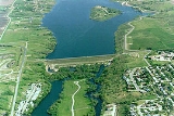
The Jamestown Dam is a rolled-earth dam
spanning the James River
in Stutsman County in the U.S. state of North Dakota
, serving the primary purpose of flood
control. It is located north of the city of Jamestown, North Dakota
. Built from April 1952 to September 1953, the dam measures 1418 feet (432.2 m) long at the crest and 85 feet (25.9 m) high. It impounds the James River to form the Jamestown Reservoir. A small islet lies shortly upstream of the dam, where the James River previously split into two channels.
The dam and reservoir rest on a wide plain of shale
where the James River cut a canyon up to 1 miles (1.6 km) wide and 100 feet (30.5 m) deep. The shale (called Pierre Shale) has a dark gray, bedded appearance, and is mostly claystone
or siltstone
. The valley also contains many traces of alluvium
, mainly deposited during the last ice age
when the area was heavily glaciated.
.
Bids for dam construction were submitted by several companies in early 1952. A bid of $1,868,862 was offered by the C.F. Lytle Company of Sioux City, Iowa
. This bid was accepted, and the contract was awarded on March 25, 1952 with the notice to proceed received on March 31. The outlet works
, which consist of four high-pressure floodgate
s, were provided by the Hardie-Tynes Manufacturing Company of Birmingham
, Alabama
, at a cost of $72,995. This contract was awarded on March 10, 1952, and the final shipment of the gates was made during February 1953.
following in early June. This wide trench served to remove as much unstable material from the foundation as possible. This material was determined to be unsuitable for construction of the dam, and eventually discarded. Placement of concrete commenced in late June. Embankment construction began in late July. The upper portion of the upstream slope of the dam was covered with a layer of riprap
, and the lower section was protected by a layer of gravel. By the end of 1952, the construction work was approximately 67% complete.
Construction continued at a rapid pace after the beginning of the 1953 season. The upstream conduits for the outlet works were completed in April, and the four high pressure gates were installed beginning April 1. These and the spillway were all complete by August 31, and the main embankment was finished by September 11. On September 18, the final concrete placement occurred, and on September 20, 1953, the dam was completed under the primary contract, 251 days ahead of schedule.
 The Jamestown Dam is 1418 feet (432.2 m) long at the crest and 85 feet (25.9 m) above the streambed of the James River
. Measured from the deepest point of excavation to the crest, the height is 110 feet (33.5 m). Its maximum thickness is 730 feet (222.5 m) from upstream toe to downstream toe. The dam embankment contains 8667000 ft3 of material, primarily dirt, rock, gravel and riprap
.
The dam's typical release rate is 1400 cuft/s. The outlet works
are controlled by four identical high-pressure gates, 5 feet by 6 feet (1.5 by 1.8 m) in size. Two are for normal use and two are for emergency releases. The maximum capacity of the outlet works is 2990 ft3 per second, or 747.5 ft3 per second per gate. The dam also has an emergency inverted-bell spillway, capable of handling 2930 ft3 per second. The total release capacity of the dam is 5920 ft3 per second.
The outlet works are designed to allow for possible future installation of hydroelectric generators and future municipal water supply.
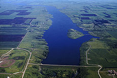
The Jamestown Reservoir typically holds 30000 acre.ft of water, with a normal surface area of 2095 acres (3.3 sq mi). Its maximum capacity is 230000 acre.ft and maximum surface area is over 13250 acres (20.7 sq mi).
 The Jamestown Dam's primary purpose is flood control, and has prevented approximately $36 million in flood-related damages. When it was constructed, certain deficiencies were noted in the foundations for the dam. When the reservoir is at normal levels, the failure risk is small, but as the water level rises, the potential for collapse increases. Floods in May 1969 caused the reservoir to rise to its record level, over 105000 acre.ft, causing leakage of the dam. This level was not even half the reservoir's maximum capacity of 230000 acre.ft. In 1993 and 1995, floods caused the lake to rise to within 1 foot (0.3048 m) of the 1969 level. An inspection by the Bureau of Reclamation's Dam Safety Department revealed that the dam could potentially fail if the deficiencies were not corrected. As a result, eight relief well
s (wells that drain a pervious stratum) were installed in the dam in 1995, and a heavy gravel filter blanket to prevent erosion of embankment materials during seepage was constructed in the spring of 1996.
, boating
, fishing
, and birding managed by the Stutsman County Park Board. The lake has approximately 45 miles (72.4 km) of shoreline and is referred to as “one of the greatest migratory waterfowl flyways in North Dakota.” It is stocked with fish by the North Dakota Game and Fish Department. Common fish species in the reservoir include pike, walleye
, crappie
, bluegill
, smallmouth bass
, muskie
and bullhead
.
Dam
A dam is a barrier that impounds water or underground streams. Dams generally serve the primary purpose of retaining water, while other structures such as floodgates or levees are used to manage or prevent water flow into specific land regions. Hydropower and pumped-storage hydroelectricity are...
spanning the James River
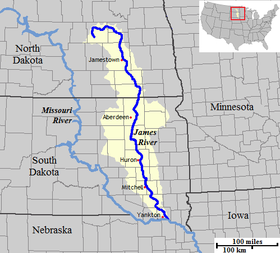
James River (Dakotas)
The James River is a tributary of the Missouri River, approximately 710 mi long, draning an area of in the U.S. states of North Dakota and South Dakota...
in Stutsman County in the U.S. state of North Dakota
North Dakota
North Dakota is a state located in the Midwestern region of the United States of America, along the Canadian border. The state is bordered by Canada to the north, Minnesota to the east, South Dakota to the south and Montana to the west. North Dakota is the 19th-largest state by area in the U.S....
, serving the primary purpose of flood
Flood
A flood is an overflow of an expanse of water that submerges land. The EU Floods directive defines a flood as a temporary covering by water of land not normally covered by water...
control. It is located north of the city of Jamestown, North Dakota
Jamestown, North Dakota
As of the census of 2000, there were 15,527 people, 6,505 households, and 3,798 families residing in the city. The population density was 1,246.7 per square mile . There were 6,970 housing units at an average density of 559.6 per square mile...
. Built from April 1952 to September 1953, the dam measures 1418 feet (432.2 m) long at the crest and 85 feet (25.9 m) high. It impounds the James River to form the Jamestown Reservoir. A small islet lies shortly upstream of the dam, where the James River previously split into two channels.
The dam and reservoir rest on a wide plain of shale
Shale
Shale is a fine-grained, clastic sedimentary rock composed of mud that is a mix of flakes of clay minerals and tiny fragments of other minerals, especially quartz and calcite. The ratio of clay to other minerals is variable. Shale is characterized by breaks along thin laminae or parallel layering...
where the James River cut a canyon up to 1 miles (1.6 km) wide and 100 feet (30.5 m) deep. The shale (called Pierre Shale) has a dark gray, bedded appearance, and is mostly claystone
Claystone
Claystone is a geological term used to describe a clastic sedimentary rock that is composed primarily of clay-sized particles ....
or siltstone
Siltstone
Siltstone is a sedimentary rock which has a grain size in the silt range, finer than sandstone and coarser than claystones.- Description :As its name implies, it is primarily composed of silt sized particles, defined as grains 1/16 - 1/256 mm or 4 to 8 on the Krumbein phi scale...
. The valley also contains many traces of alluvium
Alluvium
Alluvium is loose, unconsolidated soil or sediments, eroded, deposited, and reshaped by water in some form in a non-marine setting. Alluvium is typically made up of a variety of materials, including fine particles of silt and clay and larger particles of sand and gravel...
, mainly deposited during the last ice age
Ice age
An ice age or, more precisely, glacial age, is a generic geological period of long-term reduction in the temperature of the Earth's surface and atmosphere, resulting in the presence or expansion of continental ice sheets, polar ice sheets and alpine glaciers...
when the area was heavily glaciated.
Proposal and companies involved
The dam was proposed in 1951. The site selected offered the required storage with the smallest dam and with close access to embankment materials; however, the underlying rock and soil was both unstable and pervious. The problems were considered minor because the extended storage need of the reservoir only consisted of the lower 30 feet (9.1 m) of the reservoir. If this had not compensated for the pervious material, the required excavations to stabilize the dam would have been over 120 feet (36.6 m) to solid bedrockBedrock
In stratigraphy, bedrock is the native consolidated rock underlying the surface of a terrestrial planet, usually the Earth. Above the bedrock is usually an area of broken and weathered unconsolidated rock in the basal subsoil...
.
Bids for dam construction were submitted by several companies in early 1952. A bid of $1,868,862 was offered by the C.F. Lytle Company of Sioux City, Iowa
Iowa
Iowa is a state located in the Midwestern United States, an area often referred to as the "American Heartland". It derives its name from the Ioway people, one of the many American Indian tribes that occupied the state at the time of European exploration. Iowa was a part of the French colony of New...
. This bid was accepted, and the contract was awarded on March 25, 1952 with the notice to proceed received on March 31. The outlet works
Outlet works
A set of outlet works is a device used to release and regulate water flow from a dam. Such devices usually consist of one or more pipes or tunnels through the embankment of the dam, directing water usually under high pressure to the river downstream...
, which consist of four high-pressure floodgate
Floodgate
Floodgates are adjustable gates used to control water flow in flood barriers, reservoir, river, stream, or levee systems. They may be designed to set spillway crest heights in dams, to adjust flow rates in sluices and canals, or they may be designed to stop water flow entirely as part of a levee or...
s, were provided by the Hardie-Tynes Manufacturing Company of Birmingham
Birmingham
Birmingham is a city and metropolitan borough in the West Midlands of England. It is the most populous British city outside the capital London, with a population of 1,036,900 , and lies at the heart of the West Midlands conurbation, the second most populous urban area in the United Kingdom with a...
, Alabama
Alabama
Alabama is a state located in the southeastern region of the United States. It is bordered by Tennessee to the north, Georgia to the east, Florida and the Gulf of Mexico to the south, and Mississippi to the west. Alabama ranks 30th in total land area and ranks second in the size of its inland...
, at a cost of $72,995. This contract was awarded on March 10, 1952, and the final shipment of the gates was made during February 1953.
Construction process
Construction began in April 1952. Excavation for the outlet works began the construction process, with excavation for the 215 feet (65.5 m) wide foundation trench beginning in mid-May and excavation for the spillwaySpillway
A spillway is a structure used to provide the controlled release of flows from a dam or levee into a downstream area, typically being the river that was dammed. In the UK they may be known as overflow channels. Spillways release floods so that the water does not overtop and damage or even destroy...
following in early June. This wide trench served to remove as much unstable material from the foundation as possible. This material was determined to be unsuitable for construction of the dam, and eventually discarded. Placement of concrete commenced in late June. Embankment construction began in late July. The upper portion of the upstream slope of the dam was covered with a layer of riprap
Riprap
Riprap — also known as rip rap, rubble, shot rock or rock armour or "Rip-rap" — is rock or other material used to armor shorelines, streambeds, bridge abutments, pilings and other shoreline structures against scour, water or ice erosion.It is made from a variety of rock types, commonly granite or...
, and the lower section was protected by a layer of gravel. By the end of 1952, the construction work was approximately 67% complete.
Construction continued at a rapid pace after the beginning of the 1953 season. The upstream conduits for the outlet works were completed in April, and the four high pressure gates were installed beginning April 1. These and the spillway were all complete by August 31, and the main embankment was finished by September 11. On September 18, the final concrete placement occurred, and on September 20, 1953, the dam was completed under the primary contract, 251 days ahead of schedule.
Dam and reservoir
James River (Dakotas)
The James River is a tributary of the Missouri River, approximately 710 mi long, draning an area of in the U.S. states of North Dakota and South Dakota...
. Measured from the deepest point of excavation to the crest, the height is 110 feet (33.5 m). Its maximum thickness is 730 feet (222.5 m) from upstream toe to downstream toe. The dam embankment contains 8667000 ft3 of material, primarily dirt, rock, gravel and riprap
Riprap
Riprap — also known as rip rap, rubble, shot rock or rock armour or "Rip-rap" — is rock or other material used to armor shorelines, streambeds, bridge abutments, pilings and other shoreline structures against scour, water or ice erosion.It is made from a variety of rock types, commonly granite or...
.
The dam's typical release rate is 1400 cuft/s. The outlet works
Outlet works
A set of outlet works is a device used to release and regulate water flow from a dam. Such devices usually consist of one or more pipes or tunnels through the embankment of the dam, directing water usually under high pressure to the river downstream...
are controlled by four identical high-pressure gates, 5 feet by 6 feet (1.5 by 1.8 m) in size. Two are for normal use and two are for emergency releases. The maximum capacity of the outlet works is 2990 ft3 per second, or 747.5 ft3 per second per gate. The dam also has an emergency inverted-bell spillway, capable of handling 2930 ft3 per second. The total release capacity of the dam is 5920 ft3 per second.
The outlet works are designed to allow for possible future installation of hydroelectric generators and future municipal water supply.
The Jamestown Reservoir typically holds 30000 acre.ft of water, with a normal surface area of 2095 acres (3.3 sq mi). Its maximum capacity is 230000 acre.ft and maximum surface area is over 13250 acres (20.7 sq mi).
Flood control
Relief well
A relief well is a well drilled to intersect an oil or gas well that has experienced a blowout. Specialized liquid, such as heavy drilling mud followed by cement, can then be pumped down the relief well in order to stop the flow from the reservoir in the damaged well.The first use of a relief well...
s (wells that drain a pervious stratum) were installed in the dam in 1995, and a heavy gravel filter blanket to prevent erosion of embankment materials during seepage was constructed in the spring of 1996.
Recreation
Besides flood control, the 8 miles (12.9 km) long, 2095 acres (3.3 sq mi) Jamestown Reservoir was also created for the secondary purpose of recreation, which mainly involves campingCamping
Camping is an outdoor recreational activity. The participants leave urban areas, their home region, or civilization and enjoy nature while spending one or several nights outdoors, usually at a campsite. Camping may involve the use of a tent, caravan, motorhome, cabin, a primitive structure, or no...
, boating
Boating
Boating is the leisurely activity of travelling by boat, or the recreational use of a boat whether powerboats, sailboats, or man-powered vessels , focused on the travel itself, as well as sports activities, such as fishing or water skiing...
, fishing
Fishing
Fishing is the activity of trying to catch wild fish. Fish are normally caught in the wild. Techniques for catching fish include hand gathering, spearing, netting, angling and trapping....
, and birding managed by the Stutsman County Park Board. The lake has approximately 45 miles (72.4 km) of shoreline and is referred to as “one of the greatest migratory waterfowl flyways in North Dakota.” It is stocked with fish by the North Dakota Game and Fish Department. Common fish species in the reservoir include pike, walleye
Walleye
Walleye is a freshwater perciform fish native to most of Canada and to the northern United States. It is a North American close relative of the European pikeperch...
, crappie
Crappie
Crappie is a genus of freshwater fish in the sunfish family of order Perciformes. The type species is P. annularis, the white crappie...
, bluegill
Bluegill
The Bluegill is a species of freshwater fish sometimes referred to as bream, brim, or copper nose. It is a member of the sunfish family Centrarchidae of the order Perciformes.-Range and distribution:...
, smallmouth bass
Smallmouth bass
The smallmouth bass is a species of freshwater fish in the sunfish family of the order Perciformes. It is the type species of its genus...
, muskie
Muskie
Muskie may refer to:*Ed Muskie, American politician*Muskellunge, freshwater fish native to North America...
and bullhead
Bullhead
-Fishes:* Certain sculpins, including:** European bullhead, Cottus gobio** Siberian bullhead, Cottus poecilopus** Norway bullhead, Taurulus Liljeborgi* Catfish of the genus Ameiurus, including:** Black bullhead, Ameiurus melas...
.