

Ismere Diploma
Encyclopedia
Hide (unit)
The hide was originally an amount of land sufficient to support a household, but later in Anglo-Saxon England became a unit used in assessing land for liability to "geld", or land tax. The geld would be collected at a stated rate per hide...
of land near Ismere to Cyneberht, his "venerable companion", for the foundation of a coenubium (minster).
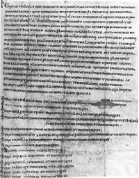
The charter survives in what is thought to be a contemporary manuscript, now in the British Library. It is written in Latin. The text is written in two different pens. The first pen is used for the charter itself, and also for the first two lines of the witnesses, and then the fourth through tenth lines of the witness list. The remaining lines are written with a thinner pen, though by the same hand that wrote the first lines written. A different scribe added another grant from Aethelbald to Cyneberht on the back. The addition of the later witnesses is an indication that the document is an original, and not a copy made later.
The charter concerns land on both sides of the river Stour
River Stour, Worcestershire
The Stour is a river flowing through the counties of Worcestershire, the West Midlands and Staffordshire in the West Midlands region of England. The Stour is a major tributary of the River Severn, and it is about in length...
with the wood of Cynibre (Kinver
Kinver
Kinver is a large village in South Staffordshire district, Staffordshire, England. It is in the far south-west of the county, at the end of the narrow finger of land surrounded by the counties of Shropshire, Worcestershire and the West Midlands. The nearest towns are Stourbridge in the West...
) on the north and the wood called Moerheb on the west. The traditional view has that the latter was to interpret Moerheb as Morfe
Morfe Forest
Morfe Forest was a medieval royal forest in east Shropshire.At its core was a wood stretching from Bridgnorth to Six Ashes and Claverley. The forest was perambulated in 1300 and the bounds were recorded...
, but this is a geographic impossibility. The wood is more likely to have become Kidderminster Heath.