
Irchel
Encyclopedia
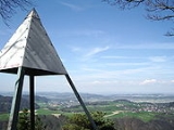
- Irchel is also the name of a hill in the city of ZürichZürichZurich is the largest city in Switzerland and the capital of the canton of Zurich. It is located in central Switzerland at the northwestern tip of Lake Zurich...
, and of a campus of Zürich University located there.

Canton of Zürich
The Canton of Zurich has a population of . The canton is located in the northeast of Switzerland and the city of Zurich is its capital. The official language is German, but people speak the local Swiss German dialect called Züritüütsch...
, located at the Rhine between the Töss and Thur
Thur River (Switzerland)
Thur is a long river in north-eastern Switzerland. Its source is near the mountain Säntis in the south-east of the canton of St. Gallen. In this canton it flows through the Toggenburg region and the town Wil. After Wil it flows through the canton of Thurgau and its capital Frauenfeld. The final ...
rivers, on the territory of Buch am Irchel
Buch am Irchel
Buch am Irchel is a municipality in the district of Andelfingen in the canton of Zürich in Switzerland.-History:Buch am Irchel is first mentioned around 1238 as Buoch. In 1244 it was mentioned as Bebinchon.-Geography:...
, Berg am Irchel
Berg am Irchel
Berg am Irchel is a municipality in the district of Andelfingen in the canton of Zürich in Switzerland.-History:Berg am Irchel is first mentioned around 1100 as Berga. In 1243 it was mentioned as Berge.-Geography:...
and Freienstein-Teufen
Freienstein-Teufen
Freienstein-Teufen is a municipality in the district of Bülach in the canton of Zürich in Switzerland.-History:Freienstein-Teufen is first mentioned in 890 as Tiuffen. In 1254 it was mentioned as Frigenstein.-Geography:...
, separating the Andelfingen
Andelfingen (district)
Andelfingen District is one of the twelve districts of the German-speaking canton of Zurich, Switzerland.It corresponds to the Zürcher Weinland, bounded by the Rhine to the north and west, by the canton of Thurgau to the east, by Winterthur to the south and by the Irchel to the southwest.-...
and Bülach districts.
It is an outlying ridge of the Jura
Jura mountains
The Jura Mountains are a small mountain range located north of the Alps, separating the Rhine and Rhone rivers and forming part of the watershed of each...
, rising to 694 m, lying east of the Lägern
Lägern
thumb|300 px|View on Lägern ridgeThe Lägern is the easternmost part of the Swiss Jura, forming the boundary between the cantons of Zurich and Aargau. Its highest elevation is the Burghorn at 859 m....
. Historically, it was part of the Germanic Limes. The name is from a Helvetic
Gaulish language
The Gaulish language is an extinct Celtic language that was spoken by the Gauls, a people who inhabited the region known as Gaul from the Iron Age through the Roman period...
word for "stag".
peaks:
- Hochwacht 668.4 m
- Forenirchel 656.4 m
- Buechemer-Irchel Höhe 694 m