
Iping
Encyclopedia
Iping is a village in the Chichester
district of West Sussex
, England
. It lies within the civil parish
of Stedham with Iping
, just off the A272 road 2 miles (3.5km) west of Midhurst
. The village lies on the River Rother. It is the setting of the classic H.G.Wells science fiction book, The Invisible Man
.
contour fort on the hill at Hammer Wood north of the village.
) and Calleva Atrebatum (Silchester
), which runs north-south through Iping. Measuring 86 x 112 metres (282 by 367 feet), the area enclosed by the turf defences was about 0.9ha (2¼ acres), and would have contained the official posting station or mansio
and perhaps an iron-smithy. It is similar in size to the way stations at Hardham
and Alfoldean on Stane Street. The station is situated at National Grid Reference SU:844261, just over two miles to the north of Iping village and little over half a mile from the crossroads in the centre of the village of Milland
, just south-east of the point where the Roman road crossed the Hammer Stream. Although unexcavated, surface finds of Roman material have been found within the confines of the earthwork. It could easily be confused with the Hammer Wood Iron Age contour fort which lies much closer to modern Iping.
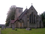
St Marys Church, Iping is a solid sandstone, Victorian church which was rebuilt in 1885. The church was built on the site of an old Saxon church and it is thought an even earlier church was on the site before this.
Iping Water Mill was producing paper until the 1920s when a fire ended 900 years of various types of milling.
Iping Common sits south of the A272 and is managed by the Sussex Wildlife Trust
. This heathland is a Site of Special Scientific Interest
.
Chichester (district)
Chichester is a largely rural local government district in West Sussex, England. Its council is based in the city of Chichester.-History:The district was formed on 1 April 1974, under the Local Government Act 1972, as a merger of the municipal borough of Chichester and the Rural Districts of...
district of West Sussex
West Sussex
West Sussex is a county in the south of England, bordering onto East Sussex , Hampshire and Surrey. The county of Sussex has been divided into East and West since the 12th century, and obtained separate county councils in 1888, but it remained a single ceremonial county until 1974 and the coming...
, England
England
England is a country that is part of the United Kingdom. It shares land borders with Scotland to the north and Wales to the west; the Irish Sea is to the north west, the Celtic Sea to the south west, with the North Sea to the east and the English Channel to the south separating it from continental...
. It lies within the civil parish
Civil parish
In England, a civil parish is a territorial designation and, where they are found, the lowest tier of local government below districts and counties...
of Stedham with Iping
Stedham with Iping
Stedham with Iping is a civil parish in the Chichester district of West Sussex, England. It is approximately two miles west of Midhurst and comprises the two villages of Stedham and Iping. There are two churches in the parish: and...
, just off the A272 road 2 miles (3.5km) west of Midhurst
Midhurst
Midhurst is a market town and civil parish in the Chichester district of West Sussex, England, with a population of 4,889 in 2001. The town is situated on the River Rother and is home to the ruin of the Tudor Cowdray House and the stately Victorian Cowdray Park...
. The village lies on the River Rother. It is the setting of the classic H.G.Wells science fiction book, The Invisible Man
The Invisible Man
The Invisible Man is a science fiction novella by H.G. Wells published in 1897. Wells' novel was originally serialised in Pearson's Weekly in 1897, and published as a novel the same year...
.
Etymology
The Saxon name means settlement of the family or followers of a man called Ipa.Iron age
There is an Iron AgeBritish Iron Age
The British Iron Age is a conventional name used in the archaeology of Great Britain, referring to the prehistoric and protohistoric phases of the Iron-Age culture of the main island and the smaller islands, typically excluding prehistoric Ireland, and which had an independent Iron Age culture of...
contour fort on the hill at Hammer Wood north of the village.
Iping Roman station
This rectangular earthwork with rounded corners lies astride the Roman road between two major British tribal centres at Noviomagus Regnorum (ChichesterChichester
Chichester is a cathedral city in West Sussex, within the historic County of Sussex, South-East England. It has a long history as a settlement; its Roman past and its subsequent importance in Anglo-Saxon times are only its beginnings...
) and Calleva Atrebatum (Silchester
Silchester
Silchester is a village and civil parish about north of Basingstoke in Hampshire. It is adjacent to the county boundary with Berkshire and about south-west of Reading....
), which runs north-south through Iping. Measuring 86 x 112 metres (282 by 367 feet), the area enclosed by the turf defences was about 0.9ha (2¼ acres), and would have contained the official posting station or mansio
Mansio
In the Roman Empire, a mansio was an official stopping place on a Roman road, or via, maintained by the central government for the use of officials and those on official business whilst travelling.-Background:The roads which traversed the Ancient World, were later surveyed,...
and perhaps an iron-smithy. It is similar in size to the way stations at Hardham
Hardham
Hardham is a small village in the Horsham District of West Sussex, England. It lies on the A29 road 1.2 miles southwest of Pulborough....
and Alfoldean on Stane Street. The station is situated at National Grid Reference SU:844261, just over two miles to the north of Iping village and little over half a mile from the crossroads in the centre of the village of Milland
Milland
Milland is a village and civil parish in the Chichester district of West Sussex, England. It is situated north of the A272 road on the border with Hampshire....
, just south-east of the point where the Roman road crossed the Hammer Stream. Although unexcavated, surface finds of Roman material have been found within the confines of the earthwork. It could easily be confused with the Hammer Wood Iron Age contour fort which lies much closer to modern Iping.
St Marys Church, Iping is a solid sandstone, Victorian church which was rebuilt in 1885. The church was built on the site of an old Saxon church and it is thought an even earlier church was on the site before this.
Iping Water Mill was producing paper until the 1920s when a fire ended 900 years of various types of milling.
Iping Common sits south of the A272 and is managed by the Sussex Wildlife Trust
Sussex Wildlife Trust
The Sussex Wildlife Trust is a wildlife trust and a registered charity covering the counties of East Sussex and West Sussex, England. The trust's Chief Executive is Tony Whitbread....
. This heathland is a Site of Special Scientific Interest
Site of Special Scientific Interest
A Site of Special Scientific Interest is a conservation designation denoting a protected area in the United Kingdom. SSSIs are the basic building block of site-based nature conservation legislation and most other legal nature/geological conservation designations in Great Britain are based upon...
.