
Inhaca
Encyclopedia
Inhaca is a settlement
in Mozambique
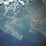
, on the subtropical Inhaca Island
(Ilha da Inhaca in Portuguese) off the East Africa
n coast. Inhaca settlement is centered on a missionary station located about 32km east of Maputo
.
(Baía de Maputo) to the west from the Indian Ocean off its eastern shores. The island's irregular coastline approaches mainland Machangulo Peninsula at Ponta Torres where a 500m-wide tidal race
separates the two headland
s. In administrative terms Inhaca is a municipal district of the municipality of Maputo, while the Machangulo peninsula
is included under the Lubombo Transfrontier Conservation Area
and is part of the district of Matutuíne, Maputo Province
.
's (Baía da Lagoa) rivers in search of ivory. A 1747 map by Emanuel Bowen
records 'Inhaqua' settlement on the mainland peninsula while referring to the island as 'I. S. Maria'.
The first light house dates from 1894, and was upgraded in the 1920's. A marine biological station (the 'MBS') 26°02′17"S 32°54′12"E was built in 1951 and some of the shores were declared nature reserves in 1976. Of late the biological station came under administration of the Eduardo Mondlane University
.
 The Inhacazul Lodge and Pestana Hotel are the main destinations of travellers from where different excursions are often undertaken, including scuba diving
and snorkelling outings. Backpackers
mostly visit a catering camping area within walking distance of the landing jetty, and are required to take bottled water and their own tents. Inhaca village is within a 5 minute drive from the camp where there are two restaurants, two bars, a grocery store and a marketplace.
The Island can be visited by means of a Ferry which departs from the Porto de Pesca, Maputo at 8:00 and returns at 15:00 every Saturday and Sunday. Travellers reach the island's landing jetty at high tide, but have to wade some sandy shallows during low tide.
There are also return flights that depart from Maputo airport and these 18 seater planes reach the island airstrip in fifteen minutes.
Town
A town is a human settlement larger than a village but smaller than a city. The size a settlement must be in order to be called a "town" varies considerably in different parts of the world, so that, for example, many American "small towns" seem to British people to be no more than villages, while...
in Mozambique
Mozambique
Mozambique, officially the Republic of Mozambique , is a country in southeastern Africa bordered by the Indian Ocean to the east, Tanzania to the north, Malawi and Zambia to the northwest, Zimbabwe to the west and Swaziland and South Africa to the southwest...
, on the subtropical Inhaca Island
Inhaca Island
Inhaca Island is a subtropical island of Mozambique off the East African coast.The 52 km² island separates Maputo Bay to the west from the Indian Ocean off its eastern shores. The island's irregular coastline approaches mainland Machangulo Peninsula at Ponta Torres where a 500m-wide tidal...
(Ilha da Inhaca in Portuguese) off the East Africa
East Africa
East Africa or Eastern Africa is the easterly region of the African continent, variably defined by geography or geopolitics. In the UN scheme of geographic regions, 19 territories constitute Eastern Africa:...
n coast. Inhaca settlement is centered on a missionary station located about 32km east of Maputo
Maputo
Maputo, also known as Lourenço Marques, is the capital and largest city of Mozambique. It is known as the City of Acacias in reference to acacia trees commonly found along its avenues and the Pearl of the Indian Ocean. It was famous for the inscription "This is Portugal" on the walkway of its...
.
Geography and administration
The 52km² island separates Maputo BayMaputo Bay
Maputo Bay , formerly Delagoa Bay, Baía da Lagoa is an inlet of the Indian Ocean on the coast of Mozambique, between 25° 40' and 26° 20' S, with a length from north to south of over 90 km long and 32 km wide....
(Baía de Maputo) to the west from the Indian Ocean off its eastern shores. The island's irregular coastline approaches mainland Machangulo Peninsula at Ponta Torres where a 500m-wide tidal race
Tidal race
Tidal race is a natural occurrence whereby a fast moving tide passes through a constriction resulting in the formation of waves, eddies and hazardous currents...
separates the two headland
Headlands and bays
Headlands and bays are two related features of the coastal environment.- Geology and geography :Headlands and bays are often found on the same coastline. A bay is surrounded by land on three sides, whereas a headland is surrounded by water on three sides. Headlands are characterized by high,...
s. In administrative terms Inhaca is a municipal district of the municipality of Maputo, while the Machangulo peninsula
Peninsula
A peninsula is a piece of land that is bordered by water on three sides but connected to mainland. In many Germanic and Celtic languages and also in Baltic, Slavic and Hungarian, peninsulas are called "half-islands"....
is included under the Lubombo Transfrontier Conservation Area
Lubombo Transfrontier Conservation Area
The Lubombo Transfrontier Conservation Area was born out of the Peace Park Foundation’s vision to establish a network of transfrontier conservation areas in southern Africa...
and is part of the district of Matutuíne, Maputo Province
Maputo Province
Maputo is a province of Mozambique; the province excludes the city of Maputo . The province has an area of 26,058 km² and a population of 1,072,086 .Matola is the capital of the province....
.
Economy
A population of about 6,000 people subsist on fishing and agriculture. At low tide women harvest crabs, oysters and fish from the western shallows. At high tide fishing boats leave the island for deeper sea fishing. The island is a popular winter destination of South African tourists.History
Tsonga chief Nhaca, a protector of early shipwrecked Portuguese sailors, lends his name to the later settlement. Later 16th century Portuguese traders established an Inhaca Island base to ply the Bay of the LagoonMaputo Bay
Maputo Bay , formerly Delagoa Bay, Baía da Lagoa is an inlet of the Indian Ocean on the coast of Mozambique, between 25° 40' and 26° 20' S, with a length from north to south of over 90 km long and 32 km wide....
's (Baía da Lagoa) rivers in search of ivory. A 1747 map by Emanuel Bowen
Emanuel Bowen
Emanuel Bowen was an English map engraver, who worked for George II of England and Louis XV of France as a geographerHe published a 'Complete Atlas of Geography,' 1744-7; an 'English Atlas, with a new set of maps,' 1745; a 'Complete Atlas .....
records 'Inhaqua' settlement on the mainland peninsula while referring to the island as 'I. S. Maria'.
The first light house dates from 1894, and was upgraded in the 1920's. A marine biological station (the 'MBS') 26°02′17"S 32°54′12"E was built in 1951 and some of the shores were declared nature reserves in 1976. Of late the biological station came under administration of the Eduardo Mondlane University
Universidade Eduardo Mondlane
The Eduardo Mondlane University is the oldest and largest university in Mozambique. The UEM is located in Maputo and has about 8,000 students.-History:...
.
Traveller's destinations
Scuba diving
Scuba diving is a form of underwater diving in which a diver uses a scuba set to breathe underwater....
and snorkelling outings. Backpackers
Backpacking (wilderness)
Backpacking combines the activities of hiking and camping for an overnight stay in backcountry wilderness...
mostly visit a catering camping area within walking distance of the landing jetty, and are required to take bottled water and their own tents. Inhaca village is within a 5 minute drive from the camp where there are two restaurants, two bars, a grocery store and a marketplace.
The Island can be visited by means of a Ferry which departs from the Porto de Pesca, Maputo at 8:00 and returns at 15:00 every Saturday and Sunday. Travellers reach the island's landing jetty at high tide, but have to wade some sandy shallows during low tide.
There are also return flights that depart from Maputo airport and these 18 seater planes reach the island airstrip in fifteen minutes.