
Indiana State Road 334
Encyclopedia
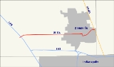
State Road 334 in the U.S. state
of Indiana
was a six-mile (10 km) route in southeastern Boone County
.
(at exit 130) with U.S. Route 421
. Its western terminus was at Indianapolis Road just west of Interstate 65. It passed through the downtown area of Zionsville
.
History=
State Road 334 was decommissioned by the Indiana Department of Transportation in the summer of 2011 and turned over to local units of government. The portion within the Town of Whitestown
was turned over to it and the portion within the Town of Zionsville
was turned over to it. The bridges along the route were turned over to Boone County
.
U.S. state
A U.S. state is any one of the 50 federated states of the United States of America that share sovereignty with the federal government. Because of this shared sovereignty, an American is a citizen both of the federal entity and of his or her state of domicile. Four states use the official title of...
of Indiana
Indiana
Indiana is a US state, admitted to the United States as the 19th on December 11, 1816. It is located in the Midwestern United States and Great Lakes Region. With 6,483,802 residents, the state is ranked 15th in population and 16th in population density. Indiana is ranked 38th in land area and is...
was a six-mile (10 km) route in southeastern Boone County
Boone County, Indiana
As of the census of 2000, there were 46,107 people, 17,081 households, and 12,810 families residing in the county. The population density was 109 people per square mile . There were 17,929 housing units at an average density of 42 per square mile...
.
Route description
State Road 334 connected Interstate 65Interstate 65
Interstate 65 is a major Interstate Highway in the United States. The southern terminus is located at an intersection with Interstate 10 in Mobile, Alabama, and its northern terminus is at an interchange with Interstate 90 , U.S. Route 12, and U.S...
(at exit 130) with U.S. Route 421
U.S. Route 421
U.S. Route 421 is a spur route of U.S. 21. It runs for from Michigan City, Indiana, at U.S. 20, to Fort Fisher in North Carolina. The highway goes through the cities of Indianapolis, Indiana, Lexington, Kentucky, Boone, North Carolina, Winston-Salem, North Carolina, Greensboro, North Carolina and...
. Its western terminus was at Indianapolis Road just west of Interstate 65. It passed through the downtown area of Zionsville
Zionsville, Indiana
-Demographics:As of the census of 2000, there were 8,775 people, 3,063 households, and 2,407 families residing in the town. The population density was 1,512.9 people per square mile . There were 3,169 housing units at an average density of 546.4 per square mile...
.
History=
State Road 334 was decommissioned by the Indiana Department of Transportation in the summer of 2011 and turned over to local units of government. The portion within the Town of Whitestown
Whitestown, Indiana
-External links:*...
was turned over to it and the portion within the Town of Zionsville
Zionsville, Indiana
-Demographics:As of the census of 2000, there were 8,775 people, 3,063 households, and 2,407 families residing in the town. The population density was 1,512.9 people per square mile . There were 3,169 housing units at an average density of 546.4 per square mile...
was turned over to it. The bridges along the route were turned over to Boone County
Boone County, Indiana
As of the census of 2000, there were 46,107 people, 17,081 households, and 12,810 families residing in the county. The population density was 109 people per square mile . There were 17,929 housing units at an average density of 42 per square mile...
.