
Indiana State Road 245
Encyclopedia
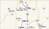
State Road 245 in the U.S. state
of Indiana
is a two-lane north–south highway in that runs entirely within Spencer County
in the southwest corner of the state.
east of Newtonville
and runs north. Passing through Santa Claus
, it is concurrent with State Road 162
and serves the Holiday World & Splashin' Safari
theme park. Past the park, the concurrent routes run along Christmas Boulevard, while the northern stretch of State Road 245 that leads northwest out of town toward Dale is called Holiday Boulevard. State Road 245 ends at State Road 62
east of Dale
.
, then south to State Road 66
northeast of Grandview
. This segment of highway was decommissioned by the state and is now a county road.
U.S. state
A U.S. state is any one of the 50 federated states of the United States of America that share sovereignty with the federal government. Because of this shared sovereignty, an American is a citizen both of the federal entity and of his or her state of domicile. Four states use the official title of...
of Indiana
Indiana
Indiana is a US state, admitted to the United States as the 19th on December 11, 1816. It is located in the Midwestern United States and Great Lakes Region. With 6,483,802 residents, the state is ranked 15th in population and 16th in population density. Indiana is ranked 38th in land area and is...
is a two-lane north–south highway in that runs entirely within Spencer County
Spencer County, Indiana
As of the census of 2000, there were 20,391 people, 7,569 households, and 5,752 families residing in the county. The population density was 51 people per square mile . There were 8,333 housing units at an average density of 21 per square mile...
in the southwest corner of the state.
Route description
State Road 245 begins at State Road 70Indiana State Road 70
State Road 70 in the U.S. state of Indiana consists of two discontinuous east–west segments of two-lane rural roadway. State Road 70 passes through no cities or towns of significant size.-Western segment:...
east of Newtonville
Newtonville, Indiana
Newtonville is an unincorporated town in Hammond Township, Spencer County, Indiana, USA....
and runs north. Passing through Santa Claus
Santa Claus, Indiana
Santa Claus is a town in Carter, Clay and Harrison townships, Spencer County in the southwestern part of the U.S. state of Indiana, between Interstate 64 and the Ohio River. The population was 2,041 at the 2000 census.Santa Claus was established in 1854...
, it is concurrent with State Road 162
Indiana State Road 162
State Road 162 in the U.S. State of Indiana is a route in Dubois and Spencer counties. Though an even-numbered route, in practice it is a north–south route for most of its length.-Route description:...
and serves the Holiday World & Splashin' Safari
Holiday World & Splashin' Safari
Holiday World & Splashin' Safari is a family owned and operated combination theme park and water park, located near Interstate 64 and U.S. 231 in Santa Claus, Indiana, USA. The theme park is divided into four sections that celebrate Christmas, Halloween, Thanksgiving and the Fourth of July with...
theme park. Past the park, the concurrent routes run along Christmas Boulevard, while the northern stretch of State Road 245 that leads northwest out of town toward Dale is called Holiday Boulevard. State Road 245 ends at State Road 62
Indiana State Road 62
State Road 62 in the U.S. State of Indiana is an east–west route that runs from the Illinois state line in the southwest corner of Indiana to the Louisville, Kentucky area, then northeast toward the Cincinnati, Ohio area.-Route description:...
east of Dale
Dale, Indiana
Dale is a town in Carter Township, Spencer County, Indiana, United States. The population was 1,593 at the 2010 census. Founded in 1843 and initially called Elizabeth, it was renamed after Robert Dale Owen of New Harmony, the town's congressman at the time....
.
History
Until March 2001, State Road 245 was concurrent with State Road 70 west through NewtonvilleNewtonville, Indiana
Newtonville is an unincorporated town in Hammond Township, Spencer County, Indiana, USA....
, then south to State Road 66
Indiana State Road 66
State Road 66 is an east–west highway in six counties in the southernmost portion of the U.S. state of Indiana.-Route description:State Road 66 begins at the eastern end of a toll bridge over the Wabash River in New Harmony and ends at U.S. Route 150 east of Hardinsburg...
northeast of Grandview
Grandview, Indiana
Grandview is a town in Hammond Township, Spencer County, Indiana, along the Ohio River. The population was 749 at the 2010 census.The town received its name because of the "grand view" of the Ohio River.-Geography:...
. This segment of highway was decommissioned by the state and is now a county road.