
Indiana State Road 243
Encyclopedia
State Road 243 is a north–south highway located in the west central part of Indiana
near Cloverdale
.
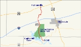
in Cunot. Going north, the highway passes through the Leiber State Recreation Area, which features the man-made Cagles Mill Lake
and Cataract Falls
, the state's largest waterfalls. Cagles Mill and Dam are also an attraction. Just north of the park, State Road 243 has an interchange with Interstate 70
. It then proceeds north to U.S. Route 40
in Putnamville
.
Indiana
Indiana is a US state, admitted to the United States as the 19th on December 11, 1816. It is located in the Midwestern United States and Great Lakes Region. With 6,483,802 residents, the state is ranked 15th in population and 16th in population density. Indiana is ranked 38th in land area and is...
near Cloverdale
Cloverdale, Indiana
Cloverdale is a town in Cloverdale and Warren townships, Putnam County, Indiana, United States. The population was 2,172 at the 2010 census.-Geography:Cloverdale is located at ....
.
Route description
The southern terminus of State Road 243 is at State Road 42Indiana State Road 42
State Road 42 is an east–west road in Central Indiana. Its western terminus is at State Road 46 in Terre Haute. Its eastern terminus is at State Road 67 and State Road 144 in Mooresville.- Route description :...
in Cunot. Going north, the highway passes through the Leiber State Recreation Area, which features the man-made Cagles Mill Lake
Cagles Mill Lake
Cagles Mill Lake, also known as Cataract Lake, is a lake located near Cataract, Indiana in Lieber State Recreation Area, in west central Indiana on the borders of Putnam and Owen counties. Mill Creek flows into from the north and drains out through to the Eel River to its south, which then makes...
and Cataract Falls
Cataract Falls (Indiana)
Cataract Falls is located in northern Owen County in the west central part of the state of Indiana. The largest waterfall by volume in the state, it is part of the Lieber State Recreation Area....
, the state's largest waterfalls. Cagles Mill and Dam are also an attraction. Just north of the park, State Road 243 has an interchange with Interstate 70
Interstate 70
Interstate 70 is an Interstate Highway in the United States that runs from Interstate 15 near Cove Fort, Utah, to a Park and Ride near Baltimore, Maryland. It was the first Interstate Highway project in the United States. I-70 approximately traces the path of U.S. Route 40 east of the Rocky...
. It then proceeds north to U.S. Route 40
U.S. Route 40
U.S. Route 40 is an east–west United States highway. As with most routes whose numbers end in a zero, U.S. 40 once traversed the entire United States. It is one of the original 1920s U.S. Highways, and its first termini were San Francisco, California, and Atlantic City, New Jersey...
in Putnamville
Putnamville, Indiana
Putnamville is an unincorporated community in Warren Township, Putnam County, Indiana, United States. It lies along U.S. Route 40 at the intersection of State Road 243. Putnamville was named after American Revolutionary War hero and Putnam County namesake Israel Putnam...
.