
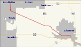
Indiana State Road 130
Encyclopedia
State Road 130 in the U.S. state
of Indiana
is a short, 11 miles (17.7 km) road that connects Lake Station
with Valparaiso
to the southeast.
in Valparaiso
to U.S. Route 6
and State Road 51
in Hobart
. This highway mainly follows a major rail line for its entire length. It is also called Lincoln Way (sometimes spelled "Lincolnway") for its entire length in Valparaiso, except south of LaPorte Avenue, where it is called Sturdy Road.
State Road 130 passes through the following cities, and intersects with highways at those locations:
State Road 130 is concurrent with SR 51 for one mile (1.6 km) south of its terminus on U.S. Route 6. State Road 51 then goes west into downtown Hobart, and State Road 130 goes southeast towards Porter County and Valparaiso.
State Road 130 can be considered a local spur of US 30. This differs from other highways, such as State Road 249
, which exist outside of the grid system and are numbered according to the nearest grid number available.
) was completed, State Road 49 was routed onto the bypass, and State Road 2 was routed with State Road 49 south to U.S. Route 30.
U.S. state
A U.S. state is any one of the 50 federated states of the United States of America that share sovereignty with the federal government. Because of this shared sovereignty, an American is a citizen both of the federal entity and of his or her state of domicile. Four states use the official title of...
of Indiana
Indiana
Indiana is a US state, admitted to the United States as the 19th on December 11, 1816. It is located in the Midwestern United States and Great Lakes Region. With 6,483,802 residents, the state is ranked 15th in population and 16th in population density. Indiana is ranked 38th in land area and is...
is a short, 11 miles (17.7 km) road that connects Lake Station
Lake Station, Indiana
Lake Station is a city in Lake County, Indiana, United States. The population was 12,572 at the 2010 census.-History:An early depot stop on the Michigan Central Railroads Detroit to Chicago line through the Calumet region, the village was first named when George Earle mapped out a town of about in...
with Valparaiso
Valparaiso, Indiana
Valparaiso is a city in and the county seat of Porter County, Indiana, United States. The population was 31,730 at the 2010 census, making it the 2nd largest city in Porter County.-History:...
to the southeast.
Route description
State Road 130 runs 11.1 miles (17.9 km) from U.S. Route 30U.S. Route 30
U.S. Route 30 is an east–west main route of the system of United States Numbered Highways, with the highway traveling across the northern tier of the country. It is the third longest U.S. route, after U.S. Route 20 and U.S. Route 6. The western end of the highway is at Astoria, Oregon; the...
in Valparaiso
Valparaiso, Indiana
Valparaiso is a city in and the county seat of Porter County, Indiana, United States. The population was 31,730 at the 2010 census, making it the 2nd largest city in Porter County.-History:...
to U.S. Route 6
U.S. Route 6
U.S. Route 6 , also called the Grand Army of the Republic Highway, a name that honors an American Civil War veterans association, is a main route of the U.S. Highway system, running east-northeast from Bishop, California to Provincetown, Massachusetts. Until 1964, it continued south from Bishop to...
and State Road 51
Indiana State Road 51
State Road 51 in the U.S. State of Indiana is a north–south route on the state highway system in northwest Indiana. It consists of a route about long from a point on U.S. Route 30 east of Merrillville and west of Valparaiso, north to U.S. Route 20 in Gary...
in Hobart
Hobart, Indiana
Hobart is home to many thriving businesses in its downtown shopping district, including the historic Art Theatre.Hobart is also home to the Westfield Southlake Shopping Mall and many surrounding retailers and restaurants, although most businesses are required to list their addresses as Merrillville...
. This highway mainly follows a major rail line for its entire length. It is also called Lincoln Way (sometimes spelled "Lincolnway") for its entire length in Valparaiso, except south of LaPorte Avenue, where it is called Sturdy Road.
State Road 130 passes through the following cities, and intersects with highways at those locations:
- HobartHobart, IndianaHobart is home to many thriving businesses in its downtown shopping district, including the historic Art Theatre.Hobart is also home to the Westfield Southlake Shopping Mall and many surrounding retailers and restaurants, although most businesses are required to list their addresses as Merrillville...
— U.S. Route 6U.S. Route 6U.S. Route 6 , also called the Grand Army of the Republic Highway, a name that honors an American Civil War veterans association, is a main route of the U.S. Highway system, running east-northeast from Bishop, California to Provincetown, Massachusetts. Until 1964, it continued south from Bishop to...
/State Road 51 - ValparaisoValparaiso, IndianaValparaiso is a city in and the county seat of Porter County, Indiana, United States. The population was 31,730 at the 2010 census, making it the 2nd largest city in Porter County.-History:...
— State Road 149, State Road 2/U.S. Route 30U.S. Route 30U.S. Route 30 is an east–west main route of the system of United States Numbered Highways, with the highway traveling across the northern tier of the country. It is the third longest U.S. route, after U.S. Route 20 and U.S. Route 6. The western end of the highway is at Astoria, Oregon; the...
(Morthland Drive)
State Road 130 is concurrent with SR 51 for one mile (1.6 km) south of its terminus on U.S. Route 6. State Road 51 then goes west into downtown Hobart, and State Road 130 goes southeast towards Porter County and Valparaiso.
State Road 130 can be considered a local spur of US 30. This differs from other highways, such as State Road 249
Indiana State Road 249
State Road 249 in the U.S. state of Indiana is a 2.4-mile connector highway in Portage in northwest Indiana. It exists to connect U.S. Route 12 and U.S. Route 20 with Interstate 94, and also to provide easy access to both highways from the steel mills and their Port of Indiana...
, which exist outside of the grid system and are numbered according to the nearest grid number available.
History
State Road 130 south of LaPorte Avenue was at one point concurrent with State Road 2. When the Valparaiso Bypass (current State Road 49Indiana State Road 49
State Road 49 in the U.S. State of Indiana is a state highway in northwest Indiana. It runs from just north of Chesterton at the intersection with U.S. Route 12 south to a rural interchange 10 miles northeast of Rensselaer with State Road 14...
) was completed, State Road 49 was routed onto the bypass, and State Road 2 was routed with State Road 49 south to U.S. Route 30.