
Indiana State Road 119
Encyclopedia
State Road 119 exists as two separate roads in the U.S state of Indiana
. The road is a rural surface highway for the entire length of both sections.
.svg.png)
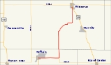
The southern section is 18.2 miles (29.3 km) long. Its southern terminus is in Buffalo
in White County
, at the intersection
of State Road 16
and State Road 39
. The roads runs east from there and is concurrent with SR 16 until that road goes south, whereas SR 119 goes north. It continues in a generally northern direction passing through Headlee
, until it terminates at U.S. Route 35 in Winamac
in Pulaski County
.
.svg.png)
The northern section is 10.22 miles (16.4 km) long and exists entirely in Elkhart County
. The southern terminus is at State Road 19
just south of Wakarusa
. The road continues northeast passing through Southwest
. Just west of Goshen
SR 119 turns due east toward State Road 15
in Goshen. In Goshen SR 119 is concurrenct with Plymouth Ave.
, now that route is part of State Road 39
.
SR 119 from Wakarusa to Goshen was part of the Plymouth
–Goshen Trail. The trail went from Plymouth to Goshen via Bremen
, the rest of the trail is now county roads.
|colspan=5 align=center |Gap in route
Indiana
Indiana is a US state, admitted to the United States as the 19th on December 11, 1816. It is located in the Midwestern United States and Great Lakes Region. With 6,483,802 residents, the state is ranked 15th in population and 16th in population density. Indiana is ranked 38th in land area and is...
. The road is a rural surface highway for the entire length of both sections.
Southern section
The southern section is 18.2 miles (29.3 km) long. Its southern terminus is in Buffalo
Buffalo, Indiana
Buffalo is a census-designated place in White County, Indiana, United States. The population was 672 at the 2000 census.-Geography:Buffalo is located at ....
in White County
White County, Indiana
As of the census of 2000, there were 25,267 people, 9,727 households, and 7,090 families residing in the county. The population density was 50 people per square mile . There were 12,083 housing units at an average density of 24 per square mile...
, at the intersection
Intersection (road)
An intersection is a road junction where two or more roads either meet or cross at grade . An intersection may be 3-way - a T junction or fork, 4-way - a crossroads, or 5-way or more...
of State Road 16
Indiana State Road 16
State Road 16 is an east–west road in Northern Indiana. Its western terminus is at U.S. Route 41 in Ade, Indiana. Its eastern terminus is at State Road 5 north of Huntington, Indiana.- Route description :...
and State Road 39
Indiana State Road 39
State Road 39 in the U.S. State of Indiana is the name of two distinct north–south highways in the state of Indiana.-Southern section:Located in south-central Indiana, the shorter southern section of State Road 39 begins at State Road 56 west of Scottsburg. It runs north and passes through...
. The roads runs east from there and is concurrent with SR 16 until that road goes south, whereas SR 119 goes north. It continues in a generally northern direction passing through Headlee
Headlee, Indiana
Headlee is a small town in Cass Township, White County, Indiana. The total population is 26. It is located on Indiana Route 119. It is also a short distance away from Lake Shafer in Buffalo and Monticello. The median household income was $29,583, and the median family income $40,446. Males had...
, until it terminates at U.S. Route 35 in Winamac
Winamac, Indiana
Winamac is a town in Monroe Township, Pulaski County, Indiana, United States. The population was 2,490 at the 2010 census. The city is the county seat of Pulaski County.-Geography:Winamac is located at ....
in Pulaski County
Pulaski County, Indiana
As of the census of 2000, there were 13,755 people, 5,170 households, and 3,779 families residing in the county. The population density was 32 people per square mile . There were 5,918 housing units at an average density of 14 per square mile...
.
Northern section
The northern section is 10.22 miles (16.4 km) long and exists entirely in Elkhart County
Elkhart County, Indiana
Elkhart County is a county in the U.S. state of Indiana. Much of the county is in the Elkhart-Goshen Metropolitan Statistical Area, which in turn is part of the South Bend-Elkhart-Mishawaka Combined Statistical Area...
. The southern terminus is at State Road 19
Indiana State Road 19
State Road 19 in the U.S. state of Indiana begins at State Road 32 in Noblesville in the south, and runs north to the Michigan state line just north of Elkhart, a distance of...
just south of Wakarusa
Wakarusa, Indiana
Wakarusa is a town in Harrison and Olive townships in Elkhart County, Indiana, United States. The population was 1,618 at the 2000 census. Wakarusa is a small farming and manufacturing community located on Indiana 19 just north of Indiana 119...
. The road continues northeast passing through Southwest
Southwest, Indiana
Southwest is an unincorporated town in Harrison Township, Elkhart County, Indiana.-Geography:Southwest is located at ....
. Just west of Goshen
Goshen, Indiana
Goshen is a city in and the county seat of Elkhart County, Indiana, United States. It is the smaller of the two principal cities of the Elkhart-Goshen Metropolitan Statistical Area, which in turn is part of the South Bend-Elkhart-Mishawaka Combined Statistical Area. It is located in the northern...
SR 119 turns due east toward State Road 15
Indiana State Road 15
State Road 15 is a north–south road in northeastern Indiana. Its southern terminus is at State Road 22 in Jonesboro. Its northern terminus is the Michigan state line north of Bristol. It is a surface highway that is mostly rural...
in Goshen. In Goshen SR 119 is concurrenct with Plymouth Ave.
History
SR 119 went as far south as MonticelloMonticello, Indiana
Monticello is a city in White County, Indiana, United States. The population was 5,378 at the 2010 census. The city is the county seat of White County....
, now that route is part of State Road 39
Indiana State Road 39
State Road 39 in the U.S. State of Indiana is the name of two distinct north–south highways in the state of Indiana.-Southern section:Located in south-central Indiana, the shorter southern section of State Road 39 begins at State Road 56 west of Scottsburg. It runs north and passes through...
.
SR 119 from Wakarusa to Goshen was part of the Plymouth
Plymouth, Indiana
-Demographics:As of the census of 2000, there were 9,840 people, 3,838 households, and 2,406 families residing in the city. The population density was 1,414.0 people per square mile . There were 4,100 housing units at an average density of 589.2 per square mile...
–Goshen Trail. The trail went from Plymouth to Goshen via Bremen
Bremen, Indiana
Bremen is a town in German Township, Marshall County, Indiana, United States. The population was 4,588 at the 2010 census.-Geography:Bremen is located at...
, the rest of the trail is now county roads.
Major intersections
|-|colspan=5 align=center |Gap in route