
Indian Mountain State Park
Encyclopedia
Indian Mountain State Park is a state park
in Campbell County, Tennessee
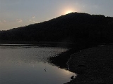
, in the southeastern United States. Established in 1971, the park consists of 213 acre (0.86198118 km²) situated at the base of Indian Mountain, a 1949 feet (594.1 m) summit that overlooks the Elk Valley in the Cumberland Mountains
. The park is located immediately west of the city of Jellico
, and the history and development of the two are intertwined to a great extent.
Indian Mountain State Park is unique in that it was developed upon an abandoned strip mine, and serves as an example of how strip-mined land can be reclaimed and used for recreational and other purposes. The park is located amidst the floodplain of Elk Creek, and a small lake and several large ponds flank the park's central area. The Tennessee-Kentucky
state line forms the park's northern boundary.
 Elk Creek flows northward from its source on the slopes of Braden Mountain to the southwest, slicing a 15 miles (24.1 km) valley between the Jellico Mountain uplands to the west and Pine Mountain to the east en route to its mouth along Clear Fork just north of the Tennessee-Kentucky border. As the creek descends to the Oswego area south of Jellico, the valley expands into a marshy floodplain approximately 1 miles (1.6 km) wide. Jellico occupies the northeastern part of this plain, and extends up the slopes of the valley's northernmost hills. Indian Mountain State Park occupies the northwestern half of the valley between Jellico and the base of Indian Mountain.
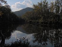
Elk Creek splits Indian Mountain State Park into eastern and western halves. The western half is dominated by the 6 acre (0.02428116 km²) Indian Mountain Lake, which spans the base of Indian Mountain and forms the southern and western boundary of the park's campground. Ballard Lake, a large pond slightly smaller than Indian Mountain Lake, dominates the park's eastern section. Several smaller ponds are scattered along the park's northern and southern boundaries. Elk Creek, which drains the park, is part of the Cumberland River
watershed.
Interstate 75
passes through the Clear Fork Valley just east of the park, connecting the area to Lexington
to the north and Knoxville
to the south. Tennessee State Route 297, which intersects U.S. Route 25W in Jellico, connects the area with Huntsville, Tennessee
to the southwest.
 Although the Cherokee
transferred possession of what is now Campbell County to the United States in 1805, the northern Elk Valley remained sparsely populated for most of the 19th century. A road connecting Campbell County with Kentucky passed through the area, and may have been used by a detachment of the Confederate
Army of East Tennessee to invade Kentucky in 1862 during the U.S. Civil War. A village known as "Smithburgh" eventually developed in the vicinity of this road, but by 1878, Smithburgh consisted of little more than a post office and a half-dozen houses.
In the early 1880s, a high quality type of coal was discovered on Jellico Mountain. Jellico coal, as it came to be known, burned relatively slowly and had a low ash content. In 1883, Smithburgh changed its name to Jellico in part to capitalize on the new demand for this coal. The discovery of coal coincided with the arrival of the railroad, making large-scale mining in the area economically feasible, and mining operations sprang up throughout the Elk Valley.
In the late 19th century and early 20th century, most coal mining operations focused on underground mining. With the success of Jellico coal, Campbell County became the largest coal producer of any county in Tennessee, producing over one million tons (appx. 900,000 metric tons) per year between 1912 and 1924. By the 1940s and 1950s, however, surface mining
had become the mining companies' preferred coal extraction method. During this period, the Saxton Coal Company operated a large surface mine at what is now Indian Mountain State Park. In 1960, after the mine's coal resources had been exhausted and the mine abandoned, the City of Jellico obtained ownership of the mine and with the help of several state and federal agencies, began restoring the denuded, unattractive land. Indian Mountain State Park opened in 1971.
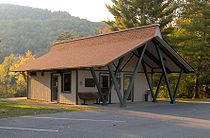
 Indian Mountain State Park currently maintains a campground with 49 fully equipped campsites, three picnic pavilions, and a large swimming pool. Indian Mountain Lake and several ponds in the park are stocked with catfish, bluegill, large-mouthed bass, and crappie to provide fishing opportunities. Pedal boats are available for rent on Indian Mountain Lake. Several athletic fields are located along London Avenue in the northeast section of the park.
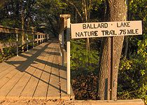
Two official walking trails meander through the park on both sides of Elk Creek. The Indian Mountain Lake Trail is a paved 1 miles (1.6 km) loop that wraps around the east bank of Indian Mountain Lake. The 0.75 miles (1.2 km) Ballard Lake Nature Trail loops along the forested banks of Ballard Lake. A third unmarked half-mile trail wraps around the pond in the southeast section of the park.
State park
State parks are parks or other protected areas managed at the federated state level within those nations which use "state" as a political subdivision. State parks are typically established by a state to preserve a location on account of its natural beauty, historic interest, or recreational...
in Campbell County, Tennessee
Campbell County, Tennessee
Campbell County is a U.S. county located in the U.S. state of Tennessee. As of 2010, the population was 40,716. Its county seat is Jacksboro. The Census Bureau has identified the county as a Micropolitan Statistical Area, designated the LaFollette Micropolitan Statistical Area for the largest...
, in the southeastern United States. Established in 1971, the park consists of 213 acre (0.86198118 km²) situated at the base of Indian Mountain, a 1949 feet (594.1 m) summit that overlooks the Elk Valley in the Cumberland Mountains
Cumberland Mountains
The Cumberland Mountains are a mountain range in the southeastern section of the Appalachian Mountains. They are located in southern West Virginia, western Virginia, eastern edges of Kentucky, and eastern middle Tennessee, including the Crab Orchard Mountains...
. The park is located immediately west of the city of Jellico
Jellico, Tennessee
Jellico is a city in Campbell County, Tennessee, United States. The population was 2,448 at the 2000 census.-Geography:Jellico is located at . The city is situated amidst the Cumberland Mountains in the Elk Creek Valley, which runs perpendicular to the Tennessee-Kentucky state line...
, and the history and development of the two are intertwined to a great extent.
Indian Mountain State Park is unique in that it was developed upon an abandoned strip mine, and serves as an example of how strip-mined land can be reclaimed and used for recreational and other purposes. The park is located amidst the floodplain of Elk Creek, and a small lake and several large ponds flank the park's central area. The Tennessee-Kentucky
Kentucky
The Commonwealth of Kentucky is a state located in the East Central United States of America. As classified by the United States Census Bureau, Kentucky is a Southern state, more specifically in the East South Central region. Kentucky is one of four U.S. states constituted as a commonwealth...
state line forms the park's northern boundary.
Geographical setting
Elk Creek splits Indian Mountain State Park into eastern and western halves. The western half is dominated by the 6 acre (0.02428116 km²) Indian Mountain Lake, which spans the base of Indian Mountain and forms the southern and western boundary of the park's campground. Ballard Lake, a large pond slightly smaller than Indian Mountain Lake, dominates the park's eastern section. Several smaller ponds are scattered along the park's northern and southern boundaries. Elk Creek, which drains the park, is part of the Cumberland River
Cumberland River
The Cumberland River is a waterway in the Southern United States. It is long. It starts in Harlan County in far southeastern Kentucky between Pine and Cumberland mountains, flows through southern Kentucky, crosses into northern Tennessee, and then curves back up into western Kentucky before...
watershed.
Interstate 75
Interstate 75
Interstate 75 is a major north–south Interstate Highway in the Great Lakes and Southeastern regions of the United States. It travels from State Road 826 and State Road 924 in Hialeah, Florida to Sault Ste. Marie, Michigan, at the Ontario, Canada, border...
passes through the Clear Fork Valley just east of the park, connecting the area to Lexington
Lexington, Kentucky
Lexington is the second-largest city in Kentucky and the 63rd largest in the US. Known as the "Thoroughbred City" and the "Horse Capital of the World", it is located in the heart of Kentucky's Bluegrass region...
to the north and Knoxville
Knoxville, Tennessee
Founded in 1786, Knoxville is the third-largest city in the U.S. state of Tennessee, U.S.A., behind Memphis and Nashville, and is the county seat of Knox County. It is the largest city in East Tennessee, and the second-largest city in the Appalachia region...
to the south. Tennessee State Route 297, which intersects U.S. Route 25W in Jellico, connects the area with Huntsville, Tennessee
Huntsville, Tennessee
Huntsville is a town in Scott County, Tennessee, United States. The population was 981 at the 2000 census. It is the county seat of Scott County.-Geography:...
to the southwest.
History
Cherokee
The Cherokee are a Native American people historically settled in the Southeastern United States . Linguistically, they are part of the Iroquoian language family...
transferred possession of what is now Campbell County to the United States in 1805, the northern Elk Valley remained sparsely populated for most of the 19th century. A road connecting Campbell County with Kentucky passed through the area, and may have been used by a detachment of the Confederate
Confederate States of America
The Confederate States of America was a government set up from 1861 to 1865 by 11 Southern slave states of the United States of America that had declared their secession from the U.S...
Army of East Tennessee to invade Kentucky in 1862 during the U.S. Civil War. A village known as "Smithburgh" eventually developed in the vicinity of this road, but by 1878, Smithburgh consisted of little more than a post office and a half-dozen houses.
In the early 1880s, a high quality type of coal was discovered on Jellico Mountain. Jellico coal, as it came to be known, burned relatively slowly and had a low ash content. In 1883, Smithburgh changed its name to Jellico in part to capitalize on the new demand for this coal. The discovery of coal coincided with the arrival of the railroad, making large-scale mining in the area economically feasible, and mining operations sprang up throughout the Elk Valley.
In the late 19th century and early 20th century, most coal mining operations focused on underground mining. With the success of Jellico coal, Campbell County became the largest coal producer of any county in Tennessee, producing over one million tons (appx. 900,000 metric tons) per year between 1912 and 1924. By the 1940s and 1950s, however, surface mining
Surface mining
Surface mining , is a type of mining in which soil and rock overlying the mineral deposit are removed...
had become the mining companies' preferred coal extraction method. During this period, the Saxton Coal Company operated a large surface mine at what is now Indian Mountain State Park. In 1960, after the mine's coal resources had been exhausted and the mine abandoned, the City of Jellico obtained ownership of the mine and with the help of several state and federal agencies, began restoring the denuded, unattractive land. Indian Mountain State Park opened in 1971.
The park today
Two official walking trails meander through the park on both sides of Elk Creek. The Indian Mountain Lake Trail is a paved 1 miles (1.6 km) loop that wraps around the east bank of Indian Mountain Lake. The 0.75 miles (1.2 km) Ballard Lake Nature Trail loops along the forested banks of Ballard Lake. A third unmarked half-mile trail wraps around the pond in the southeast section of the park.
External links
- Indian Mountain State Park — official site