

Ilhéu das Rolas
Encyclopedia

São Tomé and Príncipe
São Tomé and Príncipe, officially the Democratic Republic of São Tomé and Príncipe, is a Portuguese-speaking island nation in the Gulf of Guinea, off the western equatorial coast of Central Africa. It consists of two islands: São Tomé and Príncipe, located about apart and about , respectively, off...
, in Africa
Africa
Africa is the world's second largest and second most populous continent, after Asia. At about 30.2 million km² including adjacent islands, it covers 6% of the Earth's total surface area and 20.4% of the total land area...
. The island lies on the equator
Equator
An equator is the intersection of a sphere's surface with the plane perpendicular to the sphere's axis of rotation and containing the sphere's center of mass....
, off the southern tip of São Tomé Island
São Tomé Island
São Tomé Island, at , is the largest island of São Tomé and Príncipe and is home in 2009 to about 157,000 or 96% of the nation's population. This island and smaller nearby islets make up São Tomé Province, which is divided into six districts. The main island is located 2 km north of the...
. It is in the Caué District
Caué District
Caué is a district of São Tomé Province. Out of the seven districts that make up the equatorial Atlantic islands of São Tomé and Príncipe, it is one of the smallest in terms of population with approximately 5,900 residents, but is the largest in area covering approximately 267 square kilometers. ...
of São Tomé Province
São Tomé Island
São Tomé Island, at , is the largest island of São Tomé and Príncipe and is home in 2009 to about 157,000 or 96% of the nation's population. This island and smaller nearby islets make up São Tomé Province, which is divided into six districts. The main island is located 2 km north of the...
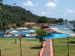
. The island is home to a small resort.
The main and almost single economic activity is tourism related mainly to the resort. A permanent population of approximately 200 people works directly in tourism.
Access to Rolas is exclusively by boat from Porto Alegre on the southernmost tip of São Tomé island.
Confirmation of equatorial position
Gago CoutinhoGago Coutinho
Carlos Viegas Gago Coutinho, GCTE, GCC, generally known simply as Gago Coutinho was a Portuguese aviation pioneer who, together with Sacadura Cabral , was the first to cross the South Atlantic Ocean by air, from March to June 1922 , from Lisbon to Rio de Janeiro.The Fairey IIIB seaplane used by...
(1869–1959), officer of the Portuguese Navy
Portuguese Navy
The Portuguese Navy is the naval branch of the Portuguese Armed Forces which, in cooperation and integrated with the other branches of the Portuguese military, is charged with the military defence of Portugal....
, navigator
Navigator
A navigator is the person on board a ship or aircraft responsible for its navigation. The navigator's primary responsibility is to be aware of ship or aircraft position at all times. Responsibilities include planning the journey, advising the Captain or aircraft Commander of estimated timing to...
and historian
Historian
A historian is a person who studies and writes about the past and is regarded as an authority on it. Historians are concerned with the continuous, methodical narrative and research of past events as relating to the human race; as well as the study of all history in time. If the individual is...
, headed a geodesic mission to São Tomé between 1915 and 1918 when marks were place as a basis for a geodetic network in the archipelago, and after that observations for triangulation, precise base measurement and astronomical observations were made.
In the process, Gago Coutinho proved that Ilhéu das Rolas is crossed by the equatorial line. The resulting map was delivered in 1919, together with the Report of the Geodetic Mission on São Tomé Island 1915–1918, that was officially considered the first complete work of practical geodesy
Geodesy
Geodesy , also named geodetics, a branch of earth sciences, is the scientific discipline that deals with the measurement and representation of the Earth, including its gravitational field, in a three-dimensional time-varying space. Geodesists also study geodynamical phenomena such as crustal...
in the Portuguese colonies.