

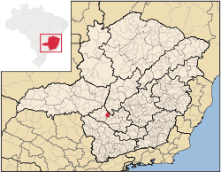
Iguatama
Encyclopedia
Minas Gerais
Minas Gerais is one of the 26 states of Brazil, of which it is the second most populous, the third richest, and the fourth largest in area. Minas Gerais is the Brazilian state with the largest number of Presidents of Brazil, the current one, Dilma Rousseff, being one of them. The capital is the...
. Its population as of 2007 was 7,632 people living in a total area of 627 km². The city belongs to the meso-region of Oeste de Minas and to the micro-region of Piumhi. It became a municipality in 1944.
Origin of the name
Iguatama is a Tupi-Guarani name, Yguaterama or Igua-terrama. This name was suggested by a local pharmacist and means "place where the river opens in bends", or "inlet of my land", or even "place where the river opens up into a lake".Location
The city center of Iguatama is located at an elevation of 664 meters. The São Francisco RiverSão Francisco River
The São Francisco is a river in Brazil. With a length of , it is the longest river that runs entirely in Brazilian territory, and the fourth longest in South America and overall in Brazil...
passes by the town. Neighboring municipalities are: Bambuí
Bambuí
Bambuí is a Brazilian municipality located in the west of the state of Minas Gerais. Its population as of 2007 was 21,850 people living in a total area of 1,455 km². The city belongs to the meso-region of Oeste de Minas and to the micro-region of Piumhi...
(N), Arcos
Arcos, Minas Gerais
Arcos is a Brazilian municipality located in the center of the state of Minas Gerais. Its population as of 2007 was 34,763 people living in a total area of 510 km². The city belongs to the meso-region of Oeste de Minas and to the micro-region of Formiga...
(E), Pains
Pains, Minas Gerais
Pains is a Brazilian municipality located in the center of the state of Minas Gerais. Its population as of 2007 was 8,122 people living in a total area of 418 km². The city belongs to the meso-region of Oeste de Minas and to the micro-region of Formiga...
(S), and Doresópolis
Doresópolis
Doresópolis is a Brazilian municipality located in the west of the state of Minas Gerais. Its population as of 2007 was 1,492 people living in a total area of 153 km². The city belongs to the meso-region of Oeste de Minas and to the micro-region of Piumhi. It became a municipality in...
(W).
The distance to Belo Horizonte
Belo Horizonte
Belo Horizonte is the capital of and largest city in the state of Minas Gerais, located in the southeastern region of Brazil. It is the third largest metropolitan area in the country...
is 258 km. The distance to the closest regional center Arcos
Arcos
-Portugal:* Arcos , a civil parish in the municipality of Anadia* Arcos , a civil parish in the municipality of Braga* Arcos , a civil parish in the municipality of Estremoz...
is 23 km. Highway connections are made by BR-354.
Economic activities
Services, small industries, and agriculture are the most important economic activities. The town is known for its cheese and traditional sweets. The GDP in 2005 was approximately R$117 million, 12 million reais from taxes, 33 million reais from services, 49 million reais from industry, and 21 million reais from agriculture. There were 339 rural producers on 37,000 hectares of land. 77 farms had tractors (2006). Approximately 900 persons were dependent on agriculture. The main crops are beans, soybeans, sorghum, and corn. There were 37,000 head of cattle (2006).There were no banks (2007) and 161 automobiles (2007), giving a ratio of 8 inhabitants per automobile.
Working population by sector
- Transformation industries (34 units): 398 workers
- Commerce (163 units): 371 workers
- Public administration: 310 workers
Health and education
In the health sector there were 2 public health clinics and 1 private hospital with 26 beds (2005). Patients with more serious health conditions are transported to DivinópolisDivinópolis
Divinópolis is a city and municipality located in the centre-west of Minas Gerais state, Brazil. The estimated population in 2007 was 201,921 inhabitants. The total area of the municipality is 709 km² and the elevation is 712 metres. It is located at 120 km from state capital Belo Horizonte...
, Lagoa da Prata
Lagoa da Prata
Lagoa da Prata is a Brazilian city in the state of Minas Gerais. In 2006, its population was estimated to be 44,628. The city belongs to the mesoregion of Central Mineira and to the microregion of Bom Despacho.-Early history:...
or Formiga
Formiga
Formiga is a and municipality in central-west Minas Gerais state, Brazil. The population of the municipality in 2007 is 64,585. The area of the municipality is 1,504 km². It is located in the statistical meso-region of Centro-Oeste de Minas and the statistical micro-region of Formiga...
. Educational needs of 1600 students were met by 8 primary schools, 2 middle schools, and 6 pre-primary schools.
- Municipal Human Development IndexHuman Development IndexThe Human Development Index is a composite statistic used to rank countries by level of "human development" and separate "very high human development", "high human development", "medium human development", and "low human development" countries...
: 0.787 (2000) - State ranking: 87 out of 853 municipalities as of 2000
- National ranking: 894 out of 5,138 municipalities as of 2000
- Literacy rate: 91%
- Life expectancy: 72 (average of males and females)
In 2000 the per capita monthly income of R$260.00 was below the state and national average of R$276.00 and R$297.00 respectively. Poços de Caldas
Poços de Caldas
Poços de Caldas is a city and municipality in south-western Minas Gerais state, Brazil, in the microregion of the same name. Its estimated population in 2009 was 151,449 inhabitants...
had the highest per capita monthly income in 2000 with R$435.00. The lowest was Setubinha
Setubinha
Setubinha is a municipality in the northeast of the Brazilian state of Minas Gerais. As of 2007 the population was 10,834 in a total area of 536 km². The elevation is 729 metres. It is part of the IBGE statistical microregion of Teófilo Otoni...
with R$73.00.
The highest ranking municipality in Minas Gerais in 2000 was Poços de Caldas
Poços de Caldas
Poços de Caldas is a city and municipality in south-western Minas Gerais state, Brazil, in the microregion of the same name. Its estimated population in 2009 was 151,449 inhabitants...
with 0.841, while the lowest was Setubinha
Setubinha
Setubinha is a municipality in the northeast of the Brazilian state of Minas Gerais. As of 2007 the population was 10,834 in a total area of 536 km². The elevation is 729 metres. It is part of the IBGE statistical microregion of Teófilo Otoni...
with 0.568. Nationally the highest was São Caetano do Sul
São Caetano do Sul
São Caetano do Sul is a city in São Paulo state in Brazil, located in the Greater São Paulo Metropolitan Area. It is the city with the highest per capita income in Brazil and it also has the highest Human Development Index .-Geography:São Caetano do Sul is located on a plateau that is part of the...
in São Paulo with 0.919, while the lowest was Setubinha. In more recent statistics (considering 5,507 municipalities) Manari in the state of Pernambuco
Pernambuco
Pernambuco is a state of Brazil, located in the Northeast region of the country. To the north are the states of Paraíba and Ceará, to the west is Piauí, to the south are Alagoas and Bahia, and to the east is the Atlantic Ocean. There are about of beaches, some of the most beautiful in the...
has the lowest rating in the country—0,467—putting it in last place.
See also
- List of municipalities in Minas Gerais