
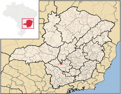
Arcos, Minas Gerais
Encyclopedia
Brazil
Brazil , officially the Federative Republic of Brazil , is the largest country in South America. It is the world's fifth largest country, both by geographical area and by population with over 192 million people...
ian municipality located in the center of the state of Minas Gerais
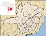
Minas Gerais
Minas Gerais is one of the 26 states of Brazil, of which it is the second most populous, the third richest, and the fourth largest in area. Minas Gerais is the Brazilian state with the largest number of Presidents of Brazil, the current one, Dilma Rousseff, being one of them. The capital is the...
. Its population as of 2007 was 34,763 people living in a total area of 510 km². The city belongs to the meso-region of Oeste de Minas and to the micro-region of Formiga. It became a municipality in 1938.
Location
The city center of Arcos is located at an elevation of 740 meters just off state highway MG-429. Neighboring municipalities are: LuzLuz, Minas Gerais
Luz is a Brazilian municipality located in the West part of the state of Minas Gerais. Luz is located between the city of Araxa and the capital city of the state of Minas Gerais, Belo Horizonte. Its population as of 2007 was 17,173 people living in a total area of 1,171 km²...
(N), Japaraíba
Japaraíba
Japaraíba is a Brazilian municipality located in the center of the state of Minas Gerais. Its population as of 2007 was 3,688 people living in a total area of 172 km². The city belongs to the meso-region of Central Mineira and to the micro-region of Bom Despacho...
(NE), Santo Antônio do Monte
Santo Antônio do Monte
Santo Antônio do Monte is a town in the western central part of the state of Minas Gerais, Brazil. Its coordinates are 20.0856/20° 5' 13" S and the longitude is 41.2495/41° 17' 38" W. It has 27,534 inhabitants . The city is located 194 km west of state capital Belo Horizonte...
(E), Formiga
Formiga
Formiga is a and municipality in central-west Minas Gerais state, Brazil. The population of the municipality in 2007 is 64,585. The area of the municipality is 1,504 km². It is located in the statistical meso-region of Centro-Oeste de Minas and the statistical micro-region of Formiga...
(SE), Córrego Fundo
Córrego Fundo
Córrego Fundo is a Brazilian municipality located in the center of the state of Minas Gerais. Its population as of 2007 was 5,635 people living in a total area of 105 km². The city belongs to the meso-region of Oeste de Minas and to the micro-region of Formiga...
(S), Pains
Pains, Minas Gerais
Pains is a Brazilian municipality located in the center of the state of Minas Gerais. Its population as of 2007 was 8,122 people living in a total area of 418 km². The city belongs to the meso-region of Oeste de Minas and to the micro-region of Formiga...
(SW), and Iguatama
Iguatama
Iguatama is a Brazilian municipality located in the west of the state of Minas Gerais. Its population as of 2007 was 7,632 people living in a total area of 627 km². The city belongs to the meso-region of Oeste de Minas and to the micro-region of Piumhi. It became a municipality in...
(W).
Distances to other cities
- Belo Horizonte/MG - 210 km
- Formiga/MG - 32 km
- Japaraíba/MG - 39 km
- Divinópolis/MG - 95 km
Origin of the name
There are several explanations for the name of the city, but the most accepted is the theory that rims ("arcos" or "aros" in Portuguese) of barrels were left on the bank of the stream that crosses the region to mark the trail for cattle heading west to the Triângulo Mineiro. The pioneers knew of the place along the stream where the barrel rims could be found. Little by little the place became known as "Córrego dos Arcos", Stream of the Barrel Rims. However the city only received the name in 1833. Before it had been called São Julião. Today this name belongs to a rural community of the municipality which has the chapel of São Julião.Economic activities
Services, mining, light industry, and agriculture are the most important economic activities. In 2005 there were 239 units of transformation industries and 935 units of commerce, vehicle repair, personal and domestic articles. There are large reserves of limestone and many workers are employed in the mining and the transformation of the product. The GDP in 2005 was approximately R$342 million, R$37 million from taxes, 157 million reais from services, 127 million reais from industry, and 20 million reais from agriculture. There were 892 rural producers on 26,000 hectares of land (2006). 125 farms had tractors (2006). Approximately 2,000 persons were involved in agriculture. The main crops are rice, beans, and corn. There were 26,000 head of cattle (2006).There were 4 banks (2007). The motor vehicle fleet had 7,708 automobiles, 886 trucks, 736 pickup trucks, and 3,0820 motorcycles.
Working population by sector
- Transformation industries: 2,389 workers
- Commerce: 2,509 workers
- Lodging and restaurants: 222 workers
- Transport, storage, communications: 702 workers
- Public administration: 752 workers
- Health and social services: 168 workers
Health and education
In the health sector there were 9 public health clinics (2005) and 1 hospital with 87 beds. Patients with more serious health conditions are transported to FormigaFormiga
Formiga is a and municipality in central-west Minas Gerais state, Brazil. The population of the municipality in 2007 is 64,585. The area of the municipality is 1,504 km². It is located in the statistical meso-region of Centro-Oeste de Minas and the statistical micro-region of Formiga...
or Belo Horizonte
Belo Horizonte
Belo Horizonte is the capital of and largest city in the state of Minas Gerais, located in the southeastern region of Brazil. It is the third largest metropolitan area in the country...
. Educational needs of 7,200 students were met by 10 primary schools, 8 middle schools, and 13 pre-primary schools.
- Municipal Human Development IndexHuman Development IndexThe Human Development Index is a composite statistic used to rank countries by level of "human development" and separate "very high human development", "high human development", "medium human development", and "low human development" countries...
: 0.808 (2000) - State ranking: 26 out of 853 municipalities as of 2000
- National ranking: 414 out of 5,138 municipalities as of 2000
- Literacy rate: 92%
- Life expectancy: 74 (average of males and females)
In 2000 the per capita monthly income of R$265.00 was below the state and national average of R$276.00 and R$297.00 respectively. Poços de Caldas
Poços de Caldas
Poços de Caldas is a city and municipality in south-western Minas Gerais state, Brazil, in the microregion of the same name. Its estimated population in 2009 was 151,449 inhabitants...
had the highest per capita monthly income in 2000 with R$435.00. The lowest was Setubinha
Setubinha
Setubinha is a municipality in the northeast of the Brazilian state of Minas Gerais. As of 2007 the population was 10,834 in a total area of 536 km². The elevation is 729 metres. It is part of the IBGE statistical microregion of Teófilo Otoni...
with R$73.00.
The highest ranking municipality in Minas Gerais in 2000 was Poços de Caldas
Poços de Caldas
Poços de Caldas is a city and municipality in south-western Minas Gerais state, Brazil, in the microregion of the same name. Its estimated population in 2009 was 151,449 inhabitants...
with 0.841, while the lowest was Setubinha
Setubinha
Setubinha is a municipality in the northeast of the Brazilian state of Minas Gerais. As of 2007 the population was 10,834 in a total area of 536 km². The elevation is 729 metres. It is part of the IBGE statistical microregion of Teófilo Otoni...
with 0.568. Nationally the highest was São Caetano do Sul
São Caetano do Sul
São Caetano do Sul is a city in São Paulo state in Brazil, located in the Greater São Paulo Metropolitan Area. It is the city with the highest per capita income in Brazil and it also has the highest Human Development Index .-Geography:São Caetano do Sul is located on a plateau that is part of the...
in São Paulo with 0.919, while the lowest was Setubinha. In more recent statistics (considering 5,507 municipalities) Manari in the state of Pernambuco
Pernambuco
Pernambuco is a state of Brazil, located in the Northeast region of the country. To the north are the states of Paraíba and Ceará, to the west is Piauí, to the south are Alagoas and Bahia, and to the east is the Atlantic Ocean. There are about of beaches, some of the most beautiful in the...
has the lowest rating in the country—0,467—putting it in last place.
See also
- List of municipalities in Minas Gerais