
Idaho State Highway 21
Encyclopedia
Idaho State Highway 21 is the Ponderosa Pine Scenic Byway, primarily a two-lane highway from Boise
to Stanley
. With two-thirds of its length in Boise County
, it passes by historic Idaho City
and the village of Lowman
to the western edge of the Sawtooth Mountains
, then along their northern boundary to Stanley.
The road is designated as one of Idaho's scenic byways and provides access to Sawtooth National Recreation Area
from Boise and the Treasure Valley
. It primarily follows the Boise River
and its tributary Mores Creek to the Boise Basin and beyond, and then the upper South Fork of the Payette River
and a tributary from Lowman to Banner Creek Summit
.
 State Highway 21 begins at exit 57 of Interstate 84
southeast of Boise, exactly 3000 feet (914 m) above sea level. The highway is an eastern extension of Gowen Road, which runs along the southern and western perimeter of the Boise Airport
(and the National Guard's Gowen Field) to connect with Orchard Road at exit 52 of I-84.
After three miles (5 km) eastbound from I-84, Highway 21 crosses the Boise River
to connect with Warm Springs Avenue, old SH-21, starting in east Boise. The highway heads upstream, briefly as a four-lane divided highway, along the north bank of the river in a basalt
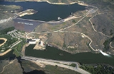
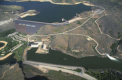
canyon. The route passes the century-old Boise River Diversion Dam
and several miles later the Lucky Peak Dam
.
After the Highland Valley Summit above the Lucky Peak Dam, SH-21 ascends the Mores Creek tributary
to the Boise Basin gold mining area centered around Idaho City
, leaving the sagebrush
to enter the Ponderosa pine
forest of the Boise National Forest
. After Idaho City, the highway continues to climb with Mores Creek for another 13 miles (21 km) to the Mores Creek Summit
at 6117 feet (1864 m), and with Beaver Creek to the Beaver Creek Summit at 6041 feet (1841 m) ten miles (16 km) further. Following this summit, Highway 21 descends 2200 feet (670 m) in switchbacks
to the village of Lowman
at 3800 feet (1158 m) above sea level. SH-21 then ascends the South Fork of the Payette River
to Grandjean on the west side of the (Sawtooths
, and climbs the Canyon Creek tributary to the Banner Creek Summit
at 7056 feet (2150 m), the route's maximum elevation
, over 3200 vertical feet (975 m) above Lowman.
At the Banner Creek Summit, SH-21 enters Custer County
and the Challis National Forest, and descends northward with Banner Creek and Cape Horn Creek, tributaries of the Middle Fork
of the Salmon River
. At "Cape Horn" the highway turns southeast to gradually climb with Marsh Creek to the border of the Sawtooth National Recreation Area
, where SH-21 enters the drainage of the main Salmon River
, and gently descends to Stanley
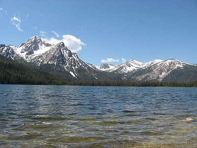
. About four miles (7 km) west of Stanley is the turnoff for the three mile (5 km) spur road to the photogenic Stanley Lake
at 6513 feet (1985 m), framed by the jagged McGown Peak at 9860 feet (3005 m).
In Stanley, SH-21 terminates at 6250 feet (1905 m) at the junction with SH-75
, the Sawtooth Scenic Byway from Galena Summit
and Ketchum
to the south, originating in Shoshone
. North of the intersection in Stanley, Highway 75 becomes the Salmon River Scenic Byway, and continues due north for a mile, then veers east with the twisty main Salmon River as it descends to Clayton, then north towards Challis
, where the route terminates and rejoins US-93 just south of the city limits.
The upper elevations of Highway 21 are often closed during the winter months,
due to light traffic and heavy snowfall.
Boise, Idaho
Boise is the capital and most populous city of the U.S. state of Idaho, as well as the county seat of Ada County. Located on the Boise River, it anchors the Boise City-Nampa metropolitan area and is the largest city between Salt Lake City, Utah and Portland, Oregon.As of the 2010 Census Bureau,...
to Stanley
Stanley, Idaho
Stanley is a city in Custer County, Idaho, United States. The population was 100 at the 2000 census. The center of population of Idaho is located in Stanley.-Geography:...
. With two-thirds of its length in Boise County
Boise County, Idaho
Boise County is a rural mountain county in the U.S. state of Idaho. The population was 6,670 at the 2000 census; it was estimated at 7,571 in 2007...
, it passes by historic Idaho City
Idaho City, Idaho
Idaho City is a city in and the county seat of Boise County, Idaho, United States, located about northeast of Boise. The population was 458 at the 2000 census.Idaho City is part of the Boise City–Nampa, Idaho Metropolitan Statistical Area.-History:...
and the village of Lowman
Lowman, Idaho
Lowman is a small unincorporated rural census-designated place in Boise County, Idaho, United States, nestled along the banks of the South Fork of the Payette River in the central part of the state...
to the western edge of the Sawtooth Mountains
Sawtooth Range (Idaho)
The Sawtooth Range is part of the Rocky Mountains, located within a few miles south of Stanley, Idaho, in the Western United States. Much of mountain range is within the Sawtooth Wilderness, part of the Sawtooth National Recreation Area...
, then along their northern boundary to Stanley.
The road is designated as one of Idaho's scenic byways and provides access to Sawtooth National Recreation Area
Sawtooth National Recreation Area
The Sawtooth National Recreation Area is a National Recreation Area located in central Idaho, within the Boise, Challis, and Sawtooth National Forests. The recreation area is managed by the U.S. Forest Service and includes the Sawtooth Wilderness...
from Boise and the Treasure Valley
Treasure Valley
The Treasure Valley is the area of the Western United States where the Payette, Boise, Weiser, Malheur, Owyhee, and Burnt rivers drain into the Snake River. Treasure Valley includes all the lowland areas from Vale, Oregon on the west to Boise, Idaho on the east. Formerly, the valley had been known...
. It primarily follows the Boise River
Boise River
The Boise River is a tributary of the Snake River in the northwestern United States. It drains a rugged portion of the Sawtooth Range in southwestern Idaho northeast of Boise, as well as part of the western Snake River Plain...
and its tributary Mores Creek to the Boise Basin and beyond, and then the upper South Fork of the Payette River
Payette River
The Payette River is an river in southwestern Idaho and is a major tributary of the Snake River.Its headwaters originate in the Sawtooth and Salmon River Mountains at elevations over...
and a tributary from Lowman to Banner Creek Summit
Banner Creek Summit
Banner Creek Summit is a mountain pass in central Idaho, at an elevation of 7056 feet above sea level on State Highway 21, the Ponderosa Pine Scenic Byway. It is located on the border of Custer County and Boise County, also the border of the Challis and Boise National Forests, immediately...
.
Route description
Interstate 84 in Idaho
In the U.S. state of Idaho, Interstate 84 heads southeast from the Oregon state line, it spurs to Interstate 184 in Boise. Eventually I-84 spurs Interstate 86 and mainline I-84 heads southeast towards Utah and I-86 is continues due east and heads to Pocatello, meeting with Interstate 15.-Future:...
southeast of Boise, exactly 3000 feet (914 m) above sea level. The highway is an eastern extension of Gowen Road, which runs along the southern and western perimeter of the Boise Airport
Boise Airport
Boise Airport , also known as Boise Air Terminal or Gowen Field, is a joint civil-military, commercial and general aviation airport located three nautical miles south of downtown Boise in Ada County, Idaho, USA...
(and the National Guard's Gowen Field) to connect with Orchard Road at exit 52 of I-84.
After three miles (5 km) eastbound from I-84, Highway 21 crosses the Boise River
Boise River
The Boise River is a tributary of the Snake River in the northwestern United States. It drains a rugged portion of the Sawtooth Range in southwestern Idaho northeast of Boise, as well as part of the western Snake River Plain...
to connect with Warm Springs Avenue, old SH-21, starting in east Boise. The highway heads upstream, briefly as a four-lane divided highway, along the north bank of the river in a basalt
Basalt
Basalt is a common extrusive volcanic rock. It is usually grey to black and fine-grained due to rapid cooling of lava at the surface of a planet. It may be porphyritic containing larger crystals in a fine matrix, or vesicular, or frothy scoria. Unweathered basalt is black or grey...
canyon. The route passes the century-old Boise River Diversion Dam
Boise River Diversion Dam
The Boise River Diversion Dam is a diversion dam on the Boise River in Idaho.In March, 1906 the Utah Fire Proofing Company began work on the Boise River Diversion Dam with the provision that the structure would be completed within one year. It soon became apparent that the dam would not be finished...
and several miles later the Lucky Peak Dam
Lucky Peak Dam
Lucky Peak Dam is a rolled earth and gravel fill dam on the Boise River in Ada County, Idaho, U.S.A.. It is directly downstream of Arrowrock Dam, a concrete arch structure completed in 1915. At the time of its construction in the early 1950s, Lucky Peak's primary purpose was flood control, with a...
.
After the Highland Valley Summit above the Lucky Peak Dam, SH-21 ascends the Mores Creek tributary
Tributary
A tributary or affluent is a stream or river that flows into a main stem river or a lake. A tributary does not flow directly into a sea or ocean...
to the Boise Basin gold mining area centered around Idaho City
Idaho City, Idaho
Idaho City is a city in and the county seat of Boise County, Idaho, United States, located about northeast of Boise. The population was 458 at the 2000 census.Idaho City is part of the Boise City–Nampa, Idaho Metropolitan Statistical Area.-History:...
, leaving the sagebrush
Sagebrush
Sagebrush is a common name of a number of shrubby plant species in the genus Artemisia native to western North America;Or, the sagebrush steppe ecoregion, having one or more kinds of sagebrush, bunchgrasses and others;...
to enter the Ponderosa pine
Ponderosa Pine
Pinus ponderosa, commonly known as the Ponderosa Pine, Bull Pine, Blackjack Pine, or Western Yellow Pine, is a widespread and variable pine native to western North America. It was first described by David Douglas in 1826, from eastern Washington near present-day Spokane...
forest of the Boise National Forest
Boise National Forest
The Boise National Forest is a US national forest located north and east of the city of Boise, Idaho. It is about 2,612,000 acres in size, ranging in elevation from 2,600 to 9,800 feet . The mountainous landscape developed through uplifting, faulting, and stream cutting...
. After Idaho City, the highway continues to climb with Mores Creek for another 13 miles (21 km) to the Mores Creek Summit
Mores Creek Summit
Mores Creek Summit is a mountain pass in southwest Idaho, United States, at an elevation of 6118 feet above sea level on State Highway 21, the Ponderosa Pine Scenic Byway. It is located in Boise County in the Boise National Forest....
at 6117 feet (1864 m), and with Beaver Creek to the Beaver Creek Summit at 6041 feet (1841 m) ten miles (16 km) further. Following this summit, Highway 21 descends 2200 feet (670 m) in switchbacks
Hairpin turn
A hairpin turn , named for its resemblance to a hairpin/bobby pin, is a bend in a road with a very acute inner angle, making it necessary for an oncoming vehicle to turn almost 180° to continue on the road. Such turns in ramps and trails may be called switchbacks in American English, by analogy...
to the village of Lowman
Lowman, Idaho
Lowman is a small unincorporated rural census-designated place in Boise County, Idaho, United States, nestled along the banks of the South Fork of the Payette River in the central part of the state...
at 3800 feet (1158 m) above sea level. SH-21 then ascends the South Fork of the Payette River
Payette River
The Payette River is an river in southwestern Idaho and is a major tributary of the Snake River.Its headwaters originate in the Sawtooth and Salmon River Mountains at elevations over...
to Grandjean on the west side of the (Sawtooths
Sawtooth Range (Idaho)
The Sawtooth Range is part of the Rocky Mountains, located within a few miles south of Stanley, Idaho, in the Western United States. Much of mountain range is within the Sawtooth Wilderness, part of the Sawtooth National Recreation Area...
, and climbs the Canyon Creek tributary to the Banner Creek Summit
Banner Creek Summit
Banner Creek Summit is a mountain pass in central Idaho, at an elevation of 7056 feet above sea level on State Highway 21, the Ponderosa Pine Scenic Byway. It is located on the border of Custer County and Boise County, also the border of the Challis and Boise National Forests, immediately...
at 7056 feet (2150 m), the route's maximum elevation
Elevation
The elevation of a geographic location is its height above a fixed reference point, most commonly a reference geoid, a mathematical model of the Earth's sea level as an equipotential gravitational surface ....
, over 3200 vertical feet (975 m) above Lowman.
At the Banner Creek Summit, SH-21 enters Custer County
Custer County, Idaho
Custer County is a rural mountain county located in the center of the U.S. state of Idaho. Established in 1881, it was named for the General Custer Mine, where gold was discovered five years earlier . The population was 4,342 at the 2000 census; it is estimated to have fallen to 4,166 by 2007...
and the Challis National Forest, and descends northward with Banner Creek and Cape Horn Creek, tributaries of the Middle Fork
Middle Fork Salmon River
The Middle Fork of the Salmon River is a river in central Idaho in the northwestern United States.- Course :The Middle Fork is a tributary of the Salmon River, which is the main tributary of the Snake River, which in turn is the main tributary to the Columbia River. The Middle Fork is one hundred...
of the Salmon River
Salmon River (Idaho)
The Salmon River is located in Idaho in the northwestern United States. The Salmon is also known as The River of No Return. It flows for through central Idaho, draining and dropping more than between its headwaters, near Galena Summit above the Sawtooth Valley in the Sawtooth National...
. At "Cape Horn" the highway turns southeast to gradually climb with Marsh Creek to the border of the Sawtooth National Recreation Area
Sawtooth National Recreation Area
The Sawtooth National Recreation Area is a National Recreation Area located in central Idaho, within the Boise, Challis, and Sawtooth National Forests. The recreation area is managed by the U.S. Forest Service and includes the Sawtooth Wilderness...
, where SH-21 enters the drainage of the main Salmon River
Salmon River (Idaho)
The Salmon River is located in Idaho in the northwestern United States. The Salmon is also known as The River of No Return. It flows for through central Idaho, draining and dropping more than between its headwaters, near Galena Summit above the Sawtooth Valley in the Sawtooth National...
, and gently descends to Stanley
Stanley, Idaho
Stanley is a city in Custer County, Idaho, United States. The population was 100 at the 2000 census. The center of population of Idaho is located in Stanley.-Geography:...
. About four miles (7 km) west of Stanley is the turnoff for the three mile (5 km) spur road to the photogenic Stanley Lake
Stanley Lake
Stanley Lake is an alpine lake in Custer County, Idaho, United States, located at the base of the Sawtooth Mountains in the Sawtooth National Recreation Area. The lake is approximately west of Stanley, readily accessed via a spur road from State Highway 21...
at 6513 feet (1985 m), framed by the jagged McGown Peak at 9860 feet (3005 m).
In Stanley, SH-21 terminates at 6250 feet (1905 m) at the junction with SH-75
Idaho State Highway 75
State Highway 75 is a two-lane highway that travels through the Sawtooth Range of central Idaho from Shoshone to Challis. The road is designated as one of Idaho's scenic byways and provides access to Sawtooth National Recreation Area...
, the Sawtooth Scenic Byway from Galena Summit
Galena Summit
Galena Summit is a high mountain pass in central Idaho, United States, at an elevation of above sea level. The pass is located in the Boulder Mountains, in the northwest corner of Blaine County, within the Sawtooth National Recreation Area of the Sawtooth National Forest.The summit is on State...
and Ketchum
Ketchum, Idaho
Ketchum is a city in Blaine County, Idaho, United States, in the central part of the state. The population was 3,003 at the 2000 census. It is in the Wood River Valley, adjacent to Sun Valley; the two communities share many resources and both sit in the same valley beneath Bald Mountain, with its...
to the south, originating in Shoshone
Shoshone, Idaho
Shoshone is the county seat and largest city of Lincoln County, Idaho, United States. The population was 1,398 at the 2000 census. In contrast to the Shoshone Native American tribe for which it is named, the city's name is correctly pronounced "Show-shown," with a silent 'e'.- History :Shoshone has...
. North of the intersection in Stanley, Highway 75 becomes the Salmon River Scenic Byway, and continues due north for a mile, then veers east with the twisty main Salmon River as it descends to Clayton, then north towards Challis
Challis, Idaho
Challis is a city in Custer County, Idaho, United States. The population was 909 at the 2000 census. The city is the county seat of Custer County.-History:...
, where the route terminates and rejoins US-93 just south of the city limits.
The upper elevations of Highway 21 are often closed during the winter months,
due to light traffic and heavy snowfall.