
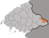
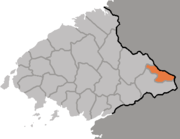
Hyangsan
Encyclopedia
Administrative divisions of North Korea
The administrative divisions of North Korea are organized into three hierarchical levels. Many of the units have equivalents in the system of South Korea. At the highest level are nine provinces, two directly governed cities, and three special administrative divisions. The second-level divisions...
, or county, in North Pyongan province, North Korea
North Korea
The Democratic People’s Republic of Korea , , is a country in East Asia, occupying the northern half of the Korean Peninsula. Its capital and largest city is Pyongyang. The Korean Demilitarized Zone serves as the buffer zone between North Korea and South Korea...
. It was established, following the division of Korea
Division of Korea
The division of Korea into North Korea and South Korea stems from the 1945 Allied victory in World War II, ending Japan's 35-year colonial rule of Korea. In a proposal opposed by nearly all Koreans, the United States and the Soviet Union agreed to temporarily occupy the country as a trusteeship...
, from portions of Nyongbyon
Nyongbyon
Nyongbyon-gun, alternatively Yongbyon-gun, is a county in North Pyongan province, North Korea. It borders the cities of Kaech'on and Anju, and covers an area of 504 km²....
county. The area of Myohyangsan mountain, which stands on the county's border, has been developed as a tourist destination. Accordingly, there are numerous tourism-related institutions in the Myohangsan area.
The Myohyangsan and Pinandok ranges pass through Hyangsan. The terrain is primarily mountainous, with numerous peaks. The highest of these is Pirobong. There are also many streams, of which the chief are the Chongchon and Kuryong Rivers. Some 77% of the county's area is occupied by forestland. The eastern side of Hyangsan is generally high, while the western side is lower; as one goes from east to west, the elevation of the peaks drops from above 1000 m to less than 300 m.
The chief local industry is agriculture, dominated by dry-field farming. The principal crops include maize, rice, and soybeans. In addition, there are also orchards and livestock farms; the chief fruit products are apples and pears. Sericulture
Sericulture
Sericulture, or silk farming, is the rearing of silkworms for the production of raw silk.Although there are several commercial species of silkworms, Bombyx mori is the most widely used and intensively studied. According to Confucian texts, the discovery of silk production by B...
is also practised, and there is some manufacturing.
The Manpo Line railroad passes through the county. In addition, there are various roads.
See also
- Geography of North KoreaGeography of North KoreaNorth Korea is located in east Asia on the northern half of the Korean Peninsula. North Korea shares a border with three states, including China along the Amnok River, Russia along the Duman River, and South Korea along the Korean Demilitarized Zone...
- Administrative divisions of North KoreaAdministrative divisions of North KoreaThe administrative divisions of North Korea are organized into three hierarchical levels. Many of the units have equivalents in the system of South Korea. At the highest level are nine provinces, two directly governed cities, and three special administrative divisions. The second-level divisions...
- North Pyongan