

Hump Ridge Track
Encyclopedia

New Zealand
New Zealand is an island country in the south-western Pacific Ocean comprising two main landmasses and numerous smaller islands. The country is situated some east of Australia across the Tasman Sea, and roughly south of the Pacific island nations of New Caledonia, Fiji, and Tonga...
.
Link to Tuatapere Hump Ridge Track website
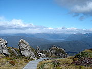
The Tuatapere Hump Ridge Track is 53 km, based in Waitutu Forest
Waitutu River
The Waitutu River is a river in southern Fiordland, New Zealand. It is the outlet of Lake Poteriteri to the sea.-References:...
(part of Fiordland National Park
Fiordland National Park
Fiordland National Park occupies the southwest corner of the South Island of New Zealand. It is the largest of the 14 national parks in New Zealand, with an area of 12,500 km², and a major part of the Te Wahipounamu World Heritage site...
). The closest town is Tuatapere
Tuatapere
Tuatapere is a small rural town in Southland, New Zealand . It is located eight kilometres from the southern coast. The Waiau River flows through the town before reaching Te Waewae Bay, where it has its outflow into Foveaux Strait...
, although people often stay in Te Anau
Te Anau
Te Anau is a town in the South Island of New Zealand. It is on the eastern shore of Lake Te Anau in Fiordland. Lake Te Anau is the largest lake in the South Island and second only within New Zealand to Lake Taupo. The 2001 census recorded the town's population as 1,857...
and opt to drive south the morning of beginning the track. The track was established in November 2001, with the township of Tuatapere fund-raising around $3 million for the project. The track crosses Māori land and much privately owned land. The Tuatapere Hump Track Trust owns the lodges and the over 20 km of board walk, although DOC maintains the track along the coast.
Route

Percy Burn Viaduct
Percy Burn Viaduct is located in the far south of the South Island of New Zealand. It is reputedly the largest surviving wooden viaduct in the world. A former logging tramway, it is now a footbridge and the most popular feature of the Tuatapere Hump Ridge Track.During the early years of the...
. The second night you stay on the coast at Port Craig Village
Port Craig, New Zealand
Port Craig is located along the south coast of the South Island New Zealand near Tuatapere.It was a small logging town born in 1916, with 200+ men women and children living there in its prime....
, with beautiful Mussel beach in easy strolling distance, then the third day returning to the start of the loop through native bush, along beautiful Blowholes Beaches and via Bluecliffs Beach.
Between six to nine hours walking is required each day to complete the track. The first day includes a 900 metre ascent to the top of the Ridge and while the second day is mostly downhill, can still be rather long towards the end.
Flora and fauna
Near the coast are dense forests of rimuRimu
Rimu can mean the following:*Dacrydium cupressinum, also rimu, a tree endemic to New Zealand*Rimu, Southland, a locality in Southland, New Zealand*Rimu, West Coast, a locality in the West Coast region of New Zealand...
, miro
Prumnopitys ferruginea
Prumnopitys ferruginea is an evergreen coniferous tree which is endemic to New Zealand. Before the genus Prumnopitys was distinguished, it was treated in the related genus Podocarpus as Podocarpus ferrugineus....
, Hall's tōtara
Podocarpus totara
Podocarpus totara is a species of podocarp tree endemic to New Zealand. It grows throughout the North Island and northeastern South Island in lowland, montane and lower subalpine forest at elevations of up to 600 m.-Description:...
and rātā
Metrosideros umbellata
Southern rātā , is a tree endemic to New Zealand. It grows up to 15 m. or more tall with a trunk up to 1 m. or more in diameter. It produces masses of red flowers in summer...
. The lower terraces are mainly podocarp and silver beech, while the higher terraces are dominated by yellow-silver pine.
Port Craig is immersed in history; the DOC hut is a 78 year old schoolhouse used in the logging days. One cannot walk off the track for more than 100 m at port craig without finding something remnant of the forestry days.
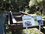
The track crosses three big viaducts, the largest, the Percy burn is thought to be the biggest wooden viaduct in the southern hemisphere and is referenced in Warren Birds book 'Viaducts to the Sky' as thought to be the largest Wooden viaduct remaining in the world.
History
The coastal track was first cut by government workers in 1896 to provide an alternative to the unreliable shipping service to Cromarty and Te Oneroa, gold mining settlements of Preservation Inlet.
In 1908 a telephone line was installed along the track linking the Puysegur Point lighthouse with Orepuki. Insulators, wire and old maintenance workers' huts can still be found today.
During the 1920s Port Craig, New Zealand
Port Craig, New Zealand
Port Craig is located along the south coast of the South Island New Zealand near Tuatapere.It was a small logging town born in 1916, with 200+ men women and children living there in its prime....
was the site of the largest and most modern sawmill in New Zealand
New Zealand
New Zealand is an island country in the south-western Pacific Ocean comprising two main landmasses and numerous smaller islands. The country is situated some east of Australia across the Tasman Sea, and roughly south of the Pacific island nations of New Caledonia, Fiji, and Tonga...
. The Marlborough Timber Company mill employed over 200 men and produced up to 1800 cubic metres of timber a month.
Logs were brought to the mill along a high class tramway from the terrace forests to the west, between Port Craig, New Zealand
Port Craig, New Zealand
Port Craig is located along the south coast of the South Island New Zealand near Tuatapere.It was a small logging town born in 1916, with 200+ men women and children living there in its prime....
and the Wairaurahiri River
Wairaurahiri River
The Wairaurahiri River is a river in southern Fiordland, New Zealand, draining Lake Hauroko into the sea.-References:...
. Large viaducts were constructed from Australian hardwood to carry the tramlines over ravines. The largest, the Percy Burn viaduct, is 125 metres long and 36 metres above the creek bed. It was fully repaired in 1994. The other viaducts were refurbished in 1999.
By the time milling ceased in 1929, about 14 square kilometres of forest had been logged, the timber being shipped directly from Port Craig, New Zealand
Port Craig, New Zealand
Port Craig is located along the south coast of the South Island New Zealand near Tuatapere.It was a small logging town born in 1916, with 200+ men women and children living there in its prime....
. Old wharf piles remain, along with old building materials and the Port Craig school, which has been converted into a hut for trampers.