
Humber Forts
Encyclopedia

Fortification
Fortifications are military constructions and buildings designed for defence in warfare and military bases. Humans have constructed defensive works for many thousands of years, in a variety of increasingly complex designs...
s in the mouth of the Humber
Humber
The Humber is a large tidal estuary on the east coast of Northern England. It is formed at Trent Falls, Faxfleet, by the confluence of the tidal River Ouse and the tidal River Trent. From here to the North Sea, it forms part of the boundary between the East Riding of Yorkshire on the north bank...
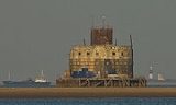
estuary in northern England: Haile Sand Fort (53°32′4"N 0°2′1"E) and Bull Sand Fort (53°33′43"N 0°4′3"E).
The two forts were planned in 1914 to protect the entrance to the estuary. They stand 18 metres (59.1 ft) above the water and have a diameter of 25 metres (82 ft). There was accommodation for 200 soldiers. Starting in May 1915, they took more than four years to build and construction was not finished until December 1919.
During World War II
World War II
World War II, or the Second World War , was a global conflict lasting from 1939 to 1945, involving most of the world's nations—including all of the great powers—eventually forming two opposing military alliances: the Allies and the Axis...
they were reactivated and modernised. The forts were regularly attacked by enemy aircraft. During this time a netting was put up to prevent enemy submarines travelling up the estuary to Hull
Kingston upon Hull
Kingston upon Hull , usually referred to as Hull, is a city and unitary authority area in the ceremonial county of the East Riding of Yorkshire, England. It stands on the River Hull at its junction with the Humber estuary, 25 miles inland from the North Sea. Hull has a resident population of...
or Grimsby
Grimsby
Grimsby is a seaport on the Humber Estuary in Lincolnshire, England. It has been the administrative centre of the unitary authority area of North East Lincolnshire since 1996...
. The forts were finally deserted by the military in 1956.
Haile Sand Fort is the smaller of the two and is situated around the low water mark between Cleethorpes
Cleethorpes
Cleethorpes is a town and unparished area in North East Lincolnshire, England, situated on the estuary of the Humber. It has a population of 31,853 and is a seaside resort.- History :...
and Humberston
Humberston
Humberston is a large village and civil parish to the south of Cleethorpes, North East Lincolnshire...
on the Lincolnshire
Lincolnshire
Lincolnshire is a county in the east of England. It borders Norfolk to the south east, Cambridgeshire to the south, Rutland to the south west, Leicestershire and Nottinghamshire to the west, South Yorkshire to the north west, and the East Riding of Yorkshire to the north. It also borders...
coast.
Bull Sand Fort is 1.5 miles (2.4 km) from shore off Spurn Head. It is a 4 storey concrete building with 12 inches (304.8 mm) of armour on the seaward side, and originally armed with four 6-inch guns
BL 6 inch Mk VII naval gun
The BL 6 inch Gun Mark VII was a British naval gun dating from 1899, which was mounted on a heavy traveling carriage in 1915 for British Army service to become one of the main heavy field guns in the First World War, and also served as one of the main coast defence guns throughout the British...
, built with great difficulty as its sandbank is 11 feet (3.4 m) below low water. In 1987 it was given a Grade II Listed Building status. In 1997 it was sold to the Streetwise Charitable Trust who are restoring the fort for use as a drug rehabilitation facility. Administratively, it is within the East Riding of Yorkshire
East Riding of Yorkshire
The East Riding of Yorkshire, or simply East Yorkshire, is a local government district with unitary authority status, and a ceremonial county of England. For ceremonial purposes the county also includes the city of Kingston upon Hull, which is a separate unitary authority...
.