

Hulme End
Encyclopedia

Introduction
Hulme End is a small hamlet in StaffordshireStaffordshire
Staffordshire is a landlocked county in the West Midlands region of England. For Eurostat purposes, the county is a NUTS 3 region and is one of four counties or unitary districts that comprise the "Shropshire and Staffordshire" NUTS 2 region. Part of the National Forest lies within its borders...
, England
England
England is a country that is part of the United Kingdom. It shares land borders with Scotland to the north and Wales to the west; the Irish Sea is to the north west, the Celtic Sea to the south west, with the North Sea to the east and the English Channel to the south separating it from continental...
. It is located in the Peak District National Park about 10 miles north of Ashbourne
Ashbourne, Derbyshire
Ashbourne is a small market town in the Derbyshire Dales, England. It has a population of 10,302.The town advertises itself as 'The Gateway to Dovedale'.- Local customs :...
. A natural gateway to the Manifold valley, the settlement is located beside the river Manifold
River Manifold
The River Manifold is a river in Staffordshire, England. It is a tributary of the River Dove ....
where it crosses the road from Hartington
Hartington
Hartington is a village in the Derbyshire Peak District, England, lying on the River Dove close to the Staffordshire border. According to the 2001 census, the parish of Hartington Town Quarter, which also includes Pilsbury, had a population of 345...
(the nearest small town) to Warslow
Warslow
Warslow is a small village in Staffordshire, England. It is located in the Peak District National Park about north of Ashbourne.Although in the county of Staffordshire, the village lies close to the Derbyshire border, and in fact has a Derbyshire postal address, i.e...
.
Although in the county of Staffordshire, the hamlet lies close to the Derbyshire
Derbyshire
Derbyshire is a county in the East Midlands of England. A substantial portion of the Peak District National Park lies within Derbyshire. The northern part of Derbyshire overlaps with the Pennines, a famous chain of hills and mountains. The county contains within its boundary of approx...
border, and in fact has a Derbyshire postal address, i.e. Hulme End, Hartington, Buxton, Derbyshire.
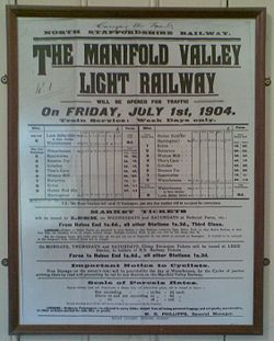
The Leek and Manifold Light Railway
The hamlet's primary significance stems from its position as the northern terminus of the former Leek and Manifold Valley Light RailwayLeek and Manifold Valley Light Railway
The Leek and Manifold Valley Light Railway was a narrow gauge railway in Staffordshire, Great Britain that operated between 1904 and 1934. When in operation, the line mainly carried milk from dairies in the region, acting as a feeder to the standard gauge system. It also provided passenger...
, a private narrow gauge
Narrow gauge
A narrow gauge railway is a railway that has a track gauge narrower than the of standard gauge railways. Most existing narrow gauge railways have gauges of between and .- Overview :...
line built following the legislation of the Light Railways Act 1896
Light Railways Act 1896
The Light Railways Act 1896 was an Act of the Parliament of the United Kingdom of Great Britain and Ireland . Before the Act each new railway line built in the country required a specific Act of Parliament to be obtained by the company that wished to construct it, which greatly added to the cost...
whereby companies could construct short lines to serve more isolated places.
The line primarily acted as a service for milk trains and tourism. On the timetable Hulme End was described as "Hulme End for Hartington" (Hartington is some 3 miles distant).
During the railway's lifetime there was some talk of extending the line northwards towards Buxton
Buxton
Buxton is a spa town in Derbyshire, England. It has the highest elevation of any market town in England. Located close to the county boundary with Cheshire to the west and Staffordshire to the south, Buxton is described as "the gateway to the Peak District National Park"...
(10 miles to the north), whereby Hulme End, with its engine and carriage sheds, would have become a natural half-way point of the line, with probable considerable resultant growth - and survival of the railway - but this never materialised.
Today the old station building has been fully restored, complete with mock beams, and is now a staffed visitor centre, open most weekends & during school holidays. Information displays outline a brief history of the railway and there is a small collection of memorabilia from the line. The centre supplies the usual range of souvenirs, guide books, maps & leaflets. Within the building are public toilets, and there is a pay-and-display car park.
Adjacent to the station, the former engine has been rebuilt to a similar design as the original; a small part of the original frameworks exists inside. The former coach sheds, which similarly had two roads, have not survived.
In 1937 the former railway was re-opened by the County Council as the Manifold Way, an 8 mile tarmacked leisure route for walkers and cyclists, some of whom use the local campsite. The only such route in the Peak District to have a metalled surface throughout its entire length, it is also ideally suited to wheelchairs and prams. Hulme End, which is served by buses, is now the start point at its northern end.
The Manifold Inn
The Manifold Inn, formerly called The Light Railway, is located beside the river Manifold. Despite its name, it is a 200 year old coaching innCoaching inn
In Europe, from approximately the mid-17th century for a period of about 200 years, the coaching inn, sometimes called a coaching house or staging inn, was a vital part of the inland transport infrastructure, as an inn serving coach travelers...
. Opposite the pub is the Old Toll House, which at one time served the turnpike
Turnpike trust
Turnpike trusts in the United Kingdom were bodies set up by individual Acts of Parliament, with powers to collect road tolls for maintaining the principal highways in Britain from the 17th but especially during the 18th and 19th centuries...
and river ford
Ford (crossing)
A ford is a shallow place with good footing where a river or stream may be crossed by wading or in a vehicle. A ford is mostly a natural phenomenon, in contrast to a low water crossing, which is an artificial bridge that allows crossing a river or stream when water is low.The names of many towns...
. The bridge that the Toll House sits on was originally built in 1790, but most of the original bridge has subsequently been replaced due to damage and collapse. The current bridge has been there since 1819.
Around the Village
The village also supports a small shop which stocks a huge range of products in a very small space. It is owned by a live-in couple called Eric and Judy.Opposite the Manifold Inn there are farm buildings which are now part of a well-run campsite.
The earliest records of this farm date back to when A.T Hulme, a doctor, resided in it. The three-storeyed Hulme End Farm on the site was bought in the late 1880s by the medical practitioner who enlarged the house and renamed it Bank House. In 1967 his grandson, Robert Bury, rebuilt the older part, which was suffering from subsidence.
This campsite and farm buildings are now collectively called Bank House Park. Bank House Park was once a farm called Bank House Farm. It used to be owned by Robert Bury, a farmer, who lived in the farm house named. After his death it was run briefly by the Manifold Inn.
The campsite is now being managed by a young couple who live in the cottage on the campsite all year round. The campsite is open from March until October and has excellent shower, toilet, drinking water and chemical disposal facilities. It also has washing up areas and extensive recycling facilities. More facilities are due to be added, planning permission pending.