
Hoosier Pass
Encyclopedia
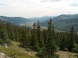
Hoosier Pass elevation 11532 ft (3,515 m) is a high mountain pass
in the Rocky Mountains
of central Colorado
in the United States
.
 The pass is located on the Continental Divide
at the northern end of the Mosquito Range
, in a gap between Mount Lincoln
(west) and Hoosier Ridge (east). It sits on the boundary between Park
(south) and Summit
(north) counties.
The pass provides a route between the headwaters of the Blue River
(tributary of the Colorado River
) to the north and the headwaters of the South Platte River
in South Park
to the south. It is traversed by State Highway 9 between the towns of Breckenridge
(north) and Fairplay
(south). The highway over the pass provides an alternative route from Denver
to the ski areas
near Breckenridge and Keystone
. It is generally open all year round, is traversable by all vehicles in good weather, but is occasionally closed during winter storms. The road over the pass has a smooth approach on the south side but has several switchbacks on the north side with a grade of 8%.
This pass is the highest point on the TransAmerica Trail, a transcontinental bicycle route that stretches from Yorktown, Virginia to Astoria, Oregon.
, near Cripple Creek
.
Mountain pass
A mountain pass is a route through a mountain range or over a ridge. If following the lowest possible route, a pass is locally the highest point on that route...
in the Rocky Mountains
Rocky Mountains
The Rocky Mountains are a major mountain range in western North America. The Rocky Mountains stretch more than from the northernmost part of British Columbia, in western Canada, to New Mexico, in the southwestern United States...
of central Colorado
Colorado
Colorado is a U.S. state that encompasses much of the Rocky Mountains as well as the northeastern portion of the Colorado Plateau and the western edge of the Great Plains...
in the United States
United States
The United States of America is a federal constitutional republic comprising fifty states and a federal district...
.
Continental Divide
The Continental Divide of the Americas, or merely the Continental Gulf of Division or Great Divide, is the name given to the principal, and largely mountainous, hydrological divide of the Americas that separates the watersheds that drain into the Pacific Ocean from those river systems that drain...
at the northern end of the Mosquito Range
Mosquito Range
The Mosquito Range is a high mountain range in the Rocky Mountains of central Colorado in the United States. The peaks of the range form a ridge running north-south for approximately 40 miles from southern Summit County on the north end, then along the boundary between Lake and Park counties...
, in a gap between Mount Lincoln
Mount Lincoln
Mount Lincoln may refer to one of several mountains in the United States:...
(west) and Hoosier Ridge (east). It sits on the boundary between Park
Park County, Colorado
Park County is the 17th most extensive of the 64 counties of the State of Colorado of the United States. The county was named after the large geographic region known as South Park, which was named by early fur traders and trappers in the area. The geographic center of the State of Colorado is...
(south) and Summit
Summit County, Colorado
Summit County is the 19th most populous of the 64 counties of the state of Colorado of the United States. The county population was 23,538 at U.S. Census 2000. The county seat is Breckenridge...
(north) counties.
The pass provides a route between the headwaters of the Blue River
Blue River (Colorado)
The Blue River is a tributary of the Colorado River, approximately long, in the U.S. state of Colorado.It rises in southern Summit County, on the western side of the continental divide in the Ten Mile Range, near Quandary Peak. It flows north past Blue River and Breckenridge, then through the...
(tributary of the Colorado River
Colorado River
The Colorado River , is a river in the Southwestern United States and northwestern Mexico, approximately long, draining a part of the arid regions on the western slope of the Rocky Mountains. The watershed of the Colorado River covers in parts of seven U.S. states and two Mexican states...
) to the north and the headwaters of the South Platte River
South Platte River
The South Platte River is one of the two principal tributaries of the Platte River and itself a major river of the American Midwest and the American Southwest/Mountain West, located in the U.S. states of Colorado and Nebraska...
in South Park
South Park (Colorado basin)
South Park is a high intermontane grassland basin, approximately 10,000 ft in elevation, in the Rocky Mountains of central Colorado. It encompasses approximately 1,000 square miles around the headwaters of the South Platte River in Park County approximately 60 mi southwest of Denver...
to the south. It is traversed by State Highway 9 between the towns of Breckenridge
Breckenridge, Colorado
Established in 1859, the historic town of Breckenridge is a home rule municipality that is the county seat of Summit County, Colorado, United States. As of the 2010 Census, the town had a population of 4,540. The town also has many part-time residents, as many people have vacation homes in the area...
(north) and Fairplay
Fairplay, Colorado
The Town of Fairplay is a statutory town that is the county seat and the most populous town of Park County, Colorado, United States. Fairplay is located in South Park at an elevation of . The town is the fifth-highest incorporated place in the State of Colorado. The population was 610 at the...
(south). The highway over the pass provides an alternative route from Denver
Denver, Colorado
The City and County of Denver is the capital and the most populous city of the U.S. state of Colorado. Denver is a consolidated city-county, located in the South Platte River Valley on the western edge of the High Plains just east of the Front Range of the Rocky Mountains...
to the ski areas
Skiing
Skiing is a recreational activity using skis as equipment for traveling over snow. Skis are used in conjunction with boots that connect to the ski with use of a binding....
near Breckenridge and Keystone
Keystone, Colorado
Keystone is a census-designated place in Summit County, Colorado, United States. The population was 825 at the 2000 census. The Dillon Post Office serves Keystone postal addresses....
. It is generally open all year round, is traversable by all vehicles in good weather, but is occasionally closed during winter storms. The road over the pass has a smooth approach on the south side but has several switchbacks on the north side with a grade of 8%.
This pass is the highest point on the TransAmerica Trail, a transcontinental bicycle route that stretches from Yorktown, Virginia to Astoria, Oregon.
Another pass
There is another Hoosier Pass in Colorado (el. 3143 m./10,313 ft.) located in Teller CountyTeller County, Colorado
Teller County is the 22nd most populous of the 64 counties of the State of Colorado of the United States. The county population was 20,555 at U.S. Census 2000. The county seat is Cripple Creek, and the most populous city is Woodland Park...
, near Cripple Creek
Cripple Creek, Colorado
The City of Cripple Creek is a Statutory City that is the county seat of Teller County, Colorado, United States. Cripple Creek is a former gold mining camp located southwest of Colorado Springs near the base of Pikes Peak. The Cripple Creek Historic District, which received National Historic...
.