
History of Williamston, Michigan
Encyclopedia
The following article describes the history of the city of Williamston, Michigan
, located in Ingham County.
 The area that was later to become Williamston was the 'summer home' of a group of Chippewa people (a band among the Ottawa tribe). This land was used by them for planting what few crops they needed, holding an annual 'spring gathering' of related bands of the tribe, and burying the dead.
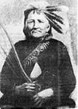
The most famous native American resident was Okemos, whose name survives as a postal address in nearby Meridian Township. Okemos ("Little Chief" or chief of subordinate authority—it is unclear if his name was meant to reference his stature—he was described as short by many contemporaries—or his authority—he had few if any directly subordinate tribesmen) had a relatively well-documented life. An ally of the British in the War of 1812, he was so badly wounded during an attack on a U.S. Cavalry unit near Sandusky that he bore a four- or five-inch-long scar from a saber on his left forehead the rest of his life. (See for example, Michigan Pioneer and Historical Society Collection, Vol. XXVII. Indian Funeral Scene. M. D. Chatterson. Lansing, MI: Robert Smith Printing Co., State Printers and Binders, 1897 for more detail.)
 The region that was later to become Williamston was first settled by people of European ancestry in 1834 by Hiram and Joseph Putnam, who moved to the area from Jackson, Michigan
. When moving, the two cut an approximately 20-mile (32 km) road through the dense forest between what is now Stockbridge
and the Cedar River (now called the Red Cedar River
). This road still exists today as Williamston Road, and, inside the Williamston city limits, it is named "Putnam Street" in the family's honor. Upon arriving in the area, the two made a 15 acres (60,702.9 m²) settlement on the north bank of the river on a former Native American planting ground, built a log cabin, and started farming the land.
, and Williamstown
, became known as "Phelpstown". In 1839, the Putnams sold their land to Oswald B., James M., and Horace B. Williams, three brothers who came from Batavia, New York. James M. "Miles" Williams, who built a dam, saw mill and later a grist mill in town, eventually plat
ted the land in 1845. The Michigan Legislature divided the original township into the two present townships in 1842, and changed the name of the eastern-most section to "Williamstown" in 1857. It is unknown how the Village lost the "w" in its name, however, the Township as it exists today retains the original spelling.
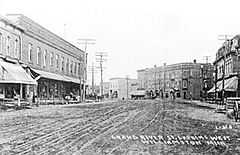
The town was a popular stop on the Grand River trail (that later became a plank road
) from Detroit
to Lansing
in the 19th century. That trail is now Grand River Avenue
(M-43
) which runs through downtown Williamston. Because the primary means of transportation at that time was the horse and buggy
and because the trip from Detroit to Lansing often took more than one day, Williamston became a convenient overnight stop.
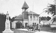 Williamston was incorporated as a village by the Michigan Legislature April 5, 1871, the same year the Howell and Lansing railroad from Detroit
to Lansing
sited a depot in Williamston as one of the intermediate stops. From this time until about World War I Williamston was the commercial and social 'hub' of the farming and early industrial society in Eastern Ingham County. After the war, the industrial growth in the area concentrated in larger cities such as Lansing
and population of Williamston stagnated as many younger residents left rural life for the city, and the businesses supporting them followed.
Williamston was incorporated as a city by vote of the population on April 1, 1945. A later revised City Charter was adopted by the people effective in April 1963. This charter has been amended several times, but remains in effect today.
A history for the area was published for the City's centennial celebration in 1971. It included many photographs and stories (and more than a few errors!) of the early city and its inhabitants. There were earlier histories, as well, published in 1963, the 1930s, and in 1880.
Williamston, Michigan
Williamston is a city in Ingham County in the U.S. state of Michigan. The city is at the southeast corner of Williamstown Township, but is politically independent. A portion of Williamston was annexed from adjacent Wheatfield Township. Downtown Williamston is located at the intersection of Grand...
, located in Ingham County.
Before Written History
The most famous native American resident was Okemos, whose name survives as a postal address in nearby Meridian Township. Okemos ("Little Chief" or chief of subordinate authority—it is unclear if his name was meant to reference his stature—he was described as short by many contemporaries—or his authority—he had few if any directly subordinate tribesmen) had a relatively well-documented life. An ally of the British in the War of 1812, he was so badly wounded during an attack on a U.S. Cavalry unit near Sandusky that he bore a four- or five-inch-long scar from a saber on his left forehead the rest of his life. (See for example, Michigan Pioneer and Historical Society Collection, Vol. XXVII. Indian Funeral Scene. M. D. Chatterson. Lansing, MI: Robert Smith Printing Co., State Printers and Binders, 1897 for more detail.)
Beginnings of European Settlement
Jackson, Michigan
Jackson is a city located along Interstate 94 in the south central area of the U.S. state of Michigan, about west of Ann Arbor and south of Lansing. It is the county seat of Jackson County. As of the 2010 census, the city population was 33,534...
. When moving, the two cut an approximately 20-mile (32 km) road through the dense forest between what is now Stockbridge
Stockbridge, Michigan
Stockbridge is a village in Stockbridge Township, Ingham County in the U.S. state of Michigan, and lies from downtown Lansing, Michigan. The population was 1,218 at the 2010 census.-History:...
and the Cedar River (now called the Red Cedar River
Red Cedar River (Michigan)
The Red Cedar River is a westward-flowing tributary of the Grand River in Michigan. Its source is Cedar Lake which is located in Marion Township in the southeastern corner of Livingston County, and it runs about through Okemos, East Lansing, including the campus of Michigan State University, and...
). This road still exists today as Williamston Road, and, inside the Williamston city limits, it is named "Putnam Street" in the family's honor. Upon arriving in the area, the two made a 15 acres (60,702.9 m²) settlement on the north bank of the river on a former Native American planting ground, built a log cabin, and started farming the land.
Phelpstown / Williamstown
After only one season of poor farming, the Putnams returned to Jackson, abandoning the land. In 1838, a settler named David Phelps moved to the region from New York State. He started a small settlement which, along with the present-day townships of LockeLocke Township, Michigan
Locke Township is a civil township of Ingham County in the U.S. state of Michigan. The population was 1,671 at the 2000 census.-Geography:According to the United States Census Bureau, the township has a total area of , of which, of it is land and 0.03% is water.-Demographics:As of the census of...
, and Williamstown
Williamstown Township, Michigan
Williamstown Township is a civil township of Ingham County in the U.S. state of Michigan, located directly to the east of East Lansing. The city of Williamston is at the southeast corner of the township, but is administratively autonomous...
, became known as "Phelpstown". In 1839, the Putnams sold their land to Oswald B., James M., and Horace B. Williams, three brothers who came from Batavia, New York. James M. "Miles" Williams, who built a dam, saw mill and later a grist mill in town, eventually plat
Plat
A plat in the U.S. is a map, drawn to scale, showing the divisions of a piece of land. Other English-speaking countries generally call such documents a cadastral map or plan....
ted the land in 1845. The Michigan Legislature divided the original township into the two present townships in 1842, and changed the name of the eastern-most section to "Williamstown" in 1857. It is unknown how the Village lost the "w" in its name, however, the Township as it exists today retains the original spelling.
The town was a popular stop on the Grand River trail (that later became a plank road
Plank road
A plank road or puncheon is a dirt path or road covered with a series of planks, similar to the wooden sidewalks one would see in a Western movie. Plank roads were very popular in Ontario, the U.S. Northeast and U.S. Midwest in the first half of the 19th century...
) from Detroit
Detroit, Michigan
Detroit is the major city among the primary cultural, financial, and transportation centers in the Metro Detroit area, a region of 5.2 million people. As the seat of Wayne County, the city of Detroit is the largest city in the U.S. state of Michigan and serves as a major port on the Detroit River...
to Lansing
Lansing, Michigan
Lansing is the capital of the U.S. state of Michigan. It is located mostly in Ingham County, although small portions of the city extend into Eaton County. The 2010 Census places the city's population at 114,297, making it the fifth largest city in Michigan...
in the 19th century. That trail is now Grand River Avenue
Grand River Avenue
US Highway 16 , also called Grand River Avenue for much of its length, is one of the principal pre-Interstate roads in the state of Michigan. Before the creation of the United States Numbered Highway System in 1926, the highway had been designated M-16...
(M-43
M-43 (Michigan highway)
M-43 is a state trunkline highway in southwestern and central parts of the US state of Michigan. The highway runs from South Haven to Webberville along an indirect path through both rural areas and larger cities...
) which runs through downtown Williamston. Because the primary means of transportation at that time was the horse and buggy
Horse and buggy
A horse and buggy or horse and carriage refers to a light, simple, two-person carriage of the late 18th, 19th and early 20th centuries, drawn usually by one or sometimes by two horses...
and because the trip from Detroit to Lansing often took more than one day, Williamston became a convenient overnight stop.
Modern Williamston
Detroit, Michigan
Detroit is the major city among the primary cultural, financial, and transportation centers in the Metro Detroit area, a region of 5.2 million people. As the seat of Wayne County, the city of Detroit is the largest city in the U.S. state of Michigan and serves as a major port on the Detroit River...
to Lansing
Lansing, Michigan
Lansing is the capital of the U.S. state of Michigan. It is located mostly in Ingham County, although small portions of the city extend into Eaton County. The 2010 Census places the city's population at 114,297, making it the fifth largest city in Michigan...
sited a depot in Williamston as one of the intermediate stops. From this time until about World War I Williamston was the commercial and social 'hub' of the farming and early industrial society in Eastern Ingham County. After the war, the industrial growth in the area concentrated in larger cities such as Lansing
Lansing, Michigan
Lansing is the capital of the U.S. state of Michigan. It is located mostly in Ingham County, although small portions of the city extend into Eaton County. The 2010 Census places the city's population at 114,297, making it the fifth largest city in Michigan...
and population of Williamston stagnated as many younger residents left rural life for the city, and the businesses supporting them followed.
Williamston was incorporated as a city by vote of the population on April 1, 1945. A later revised City Charter was adopted by the people effective in April 1963. This charter has been amended several times, but remains in effect today.
A history for the area was published for the City's centennial celebration in 1971. It included many photographs and stories (and more than a few errors!) of the early city and its inhabitants. There were earlier histories, as well, published in 1963, the 1930s, and in 1880.