

Highwood River
Encyclopedia
The Highwood River is a river located in southwestern Alberta
, Canada
. It is part of the Bow River
watershed
. The river is known for its flyfishing. A variety of trout species live in the river, including native bull trout
.
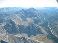 The Highwood originates in the Canadian Rockies
in Peter Lougheed Provincial Park
, in the Highwood Pass
below Mount Arethusa
. It flows south and is paralleled by the Kananaskis Trail between Elbow-Sheep Wildland, Don Getty Wildland and Emerson Creek Park. It turns east and flows along Highway 541 and through the community of Longview
. Continuing east, it passes through High River
, ending when it enters the Bow River
southeast of Calgary
.
Alberta
Alberta is a province of Canada. It had an estimated population of 3.7 million in 2010 making it the most populous of Canada's three prairie provinces...
, Canada
Canada
Canada is a North American country consisting of ten provinces and three territories. Located in the northern part of the continent, it extends from the Atlantic Ocean in the east to the Pacific Ocean in the west, and northward into the Arctic Ocean...
. It is part of the Bow River
Bow River
The Bow River is a river in the Canadian province of Alberta. It is a tributary of the South Saskatchewan River, and is considered the headwater of the Nelson River....
watershed
Drainage basin
A drainage basin is an extent or an area of land where surface water from rain and melting snow or ice converges to a single point, usually the exit of the basin, where the waters join another waterbody, such as a river, lake, reservoir, estuary, wetland, sea, or ocean...
. The river is known for its flyfishing. A variety of trout species live in the river, including native bull trout
Bull trout
The bull trout, Salvelinus confluentus, is a char of the family Salmonidae native to northwestern North America. Historically, S. confluentus has been known as the "Dolly Varden" , but was re-classified as a separate species in 1980. Bull trout are listed as a threatened species under the U.S....
.
Course
Canadian Rockies
The Canadian Rockies comprise the Canadian segment of the North American Rocky Mountains range. They are the eastern part of the Canadian Cordillera, extending from the Interior Plains of Alberta to the Rocky Mountain Trench of British Columbia. The southern end borders Idaho and Montana of the USA...
in Peter Lougheed Provincial Park
Peter Lougheed Provincial Park
Peter Lougheed Provincial Park is a provincial park located in Alberta, Canada. The park is located in Kananaskis Country approximately 90 km west of Calgary, along the Kananaskis Trail....
, in the Highwood Pass
Highwood Pass
Highwood Pass is a mountain pass in Kananaskis Country, Alberta, Canada. It lies west of Mount Rae and Mount Arethusa of the Misty Range, south of the Elbow Pass.It lies within the Peter Lougheed Provincial Park...
below Mount Arethusa
Mount Arethusa
Mount Arethusa is a mountain in the Canadian Rockies of Alberta, Canada.It is located alongside Highway 40, immediately east of the Highwood Pass parking lot in Kananaskis Country, and is a part of the Misty Range of the Southern Continental Ranges.Mt...
. It flows south and is paralleled by the Kananaskis Trail between Elbow-Sheep Wildland, Don Getty Wildland and Emerson Creek Park. It turns east and flows along Highway 541 and through the community of Longview
Longview, Alberta
Longview is a village in southern Alberta, Canada. It is located in the Canadian Rockies foothills, on Cowboy Trail, 32 km west of High River and 64 km south of Calgary...
. Continuing east, it passes through High River
High River, Alberta
High River is a town in southwestern Alberta, Canada with a population of 10,716. It is south of the city of Calgary, at the junction of Alberta Highways 2 and 23...
, ending when it enters the Bow River
Bow River
The Bow River is a river in the Canadian province of Alberta. It is a tributary of the South Saskatchewan River, and is considered the headwater of the Nelson River....
southeast of Calgary
Calgary
Calgary is a city in the Province of Alberta, Canada. It is located in the south of the province, in an area of foothills and prairie, approximately east of the front ranges of the Canadian Rockies...
.
Tributaries and features along course
From origin to mouth, the Highwood River receives the following tributaries or passes through these geographic features:| Tributary or feature | Location | Remarks |
|---|---|---|
| Storm Creek | 50.56597°N 114.95302°W | left tributary from Storm Mountain Storm Mountain (Alberta) Storm Mountain is a mountain in the Alberta's Rockies, Canada.It is located alongside Highway 40, southwest of the Highwood Pass parking lot in Kananaskis Country, and is part of the Misty Range of the Canadian Rockies... |
| Kananaskis Trail | 50.54084°N 114.94909°W | Bridge |
| Mist Creek | 50.51388°N 114.83849°W | left tributary from Mist Mountain Mist Mountain Mist Mountain is a mountain located alongside Highway 40 in the Canadian Rockies of Alberta, Canada.It reaches an elevation of and is visible from Alberta Highway 40 and the Sheep River.The mountain was named in 1884 by George M. Dawson.-External links:... |
| Picklejar Creek | 50.50687°N 114.82833°W | left tributary |
| Loomis Creek | 50.46714°N 114.78512°W | right tributary |
| McPhail Creek | 50.41631°N 114.74539°W | right tributary |
| Cat Creek | 50.40797°N 114.71243°W | left tributary |
| Strawberry Creek | 50.38248°N 114.67775°W | right tributary |
| Fitzsimmons Creek | 50.37914°N 114.65781°W | right tributary |
| Etherington Cree | 50.37944°N 114.64946°W | right tributary |
| Stony Creek | 50.38832°N 114.61922°W | left tributary |
| Cataract Creek | 50.38986°N 114.58254°W | right tributary |
| Zephyr Creek | 50.38977°N 114.57551°W | right tributary |
| Marston Creek | 50.40470°N 114.50136°W | left tributary |
| Deep Creek | 50.42343°N 114.46994°W | left tributary |
| Eden Valley Indian Reserve Indian reserve In Canada, an Indian reserve is specified by the Indian Act as a "tract of land, the legal title to which is vested in Her Majesty, that has been set apart by Her Majesty for the use and benefit of a band." The Act also specifies that land reserved for the use and benefit of a band which is not... 216 |
50.42061°N 114.47585°W | enters reserve Indian reserve In Canada, an Indian reserve is specified by the Indian Act as a "tract of land, the legal title to which is vested in Her Majesty, that has been set apart by Her Majesty for the use and benefit of a band." The Act also specifies that land reserved for the use and benefit of a band which is not... |
| Eden Valley Indian Reserve 216 | 50.45863°N 114.42421°W | leaves reserve |
| Waldie Creek | 50.47466°N 114.41978°W | left tributary |
| Trap Creek | 50.47849°N 114.41952°W | left tributary |
| Sullivan Creek | 50.53074°N 114.38507°W | left tributary |
| Ings Creek | 50.55979°N 114.33701°W | left tributary |
| Longview Longview, Alberta Longview is a village in southern Alberta, Canada. It is located in the Canadian Rockies foothills, on Cowboy Trail, 32 km west of High River and 64 km south of Calgary... |
50.53301°N 114.24000°W | enters town limits |
| Cowboy Trail | 50.52346°N 114.23348°W | bridge |
| Bull Creek | 50.50548°N 114.23275°W | right tributary |
| Pekisko Creek | 50.48207°N 114.12843°W | right tributary |
| High River High River, Alberta High River is a town in southwestern Alberta, Canada with a population of 10,716. It is south of the city of Calgary, at the junction of Alberta Highways 2 and 23... |
50.57573°N 113.90574°W | enters town limits |
| Highway 2A | 50.58308°N 113.87239°W | road and railroad bridge |
| Tongue Creek | 50.63876°N 113.87181°W | left tributary |
| CPR Canadian Pacific Railway The Canadian Pacific Railway , formerly also known as CP Rail between 1968 and 1996, is a historic Canadian Class I railway founded in 1881 and now operated by Canadian Pacific Railway Limited, which began operations as legal owner in a corporate restructuring in 2001... |
50.65727°N 113.85934°W | railroad bridge |
| Highway 2 | 50.66836°N 113.86222°W | bridge |
| Highway 547 | 50.69705°N 113.86396°W | bridge |
| Sheep River | 50.74024°N 113.85580°W | left tributary |
| Highway 552 | 50.78368°N 113.82126°W | bridge |
| Bow River Bow River The Bow River is a river in the Canadian province of Alberta. It is a tributary of the South Saskatchewan River, and is considered the headwater of the Nelson River.... |
50.81898°N 113.77845°W | river mouth as right tributary of Bow River |