
.gif)
Highway D2 (Slovakia)
Encyclopedia
D2 is a motorway in Slovakia
.
It connects the Czech
border at Kúty
with the Hungarian
border at Čunovo
, passing through (ordered north to south) Malacky
, Bratislava
and Jarovce
. It is part of the European routes E65
and E75
and of the Pan-European corridor IV. The length of the motorway is 80 km.
was completed, joining the three most important cities in the country (Prague
, Brno and Bratislava). A new planned segment from Bratislava to the Hungarian border was added in 1987. Construction continued with the building of the Lafranconi Bridge
in Bratislava and the junction with D1 motorway junction and temporary end in Petržalka
in the years 1985 - 1991 and after its opening, construction stopped for five years. It continues further since 1996, with the sections from temporary end to Hungary and Austria, with all being opened in 1998 and with the 8.5 km segment from D4 junction to the Hungarian border being widened in 2002. Today, the motorway is complete, with the last 3 km in Bratislava with the only tunnel in its entire length, the Sitina Tunnel
opened on 24 June 2007.
Slovakia
The Slovak Republic is a landlocked state in Central Europe. It has a population of over five million and an area of about . Slovakia is bordered by the Czech Republic and Austria to the west, Poland to the north, Ukraine to the east and Hungary to the south...
.
It connects the Czech
Czech Republic
The Czech Republic is a landlocked country in Central Europe. The country is bordered by Poland to the northeast, Slovakia to the east, Austria to the south, and Germany to the west and northwest....
border at Kúty
Kúty
Kúty, is a village and municipality in Senica District in the Trnava Region of western Slovakia.-Geography:The municipality lies at an altitude of 156 metres and covers an area of 27.158 km²...
with the Hungarian
Hungary
Hungary , officially the Republic of Hungary , is a landlocked country in Central Europe. It is situated in the Carpathian Basin and is bordered by Slovakia to the north, Ukraine and Romania to the east, Serbia and Croatia to the south, Slovenia to the southwest and Austria to the west. The...
border at Čunovo
Cunovo
Čunovo is a small part of Bratislava, Slovakia, in the southern area near the Hungarian border. It is located close to the Gabčíkovo - Nagymaros Dams.- History :...
, passing through (ordered north to south) Malacky
Malacky
Malacky is a town and municipality in western Slovakia around 35 km north from capital Bratislava. From the second half of the 10th century until 1918, it was part of the Kingdom of Hungary...
, Bratislava
Bratislava
Bratislava is the capital of Slovakia and, with a population of about 431,000, also the country's largest city. Bratislava is in southwestern Slovakia on both banks of the Danube River. Bordering Austria and Hungary, it is the only national capital that borders two independent countries.Bratislava...
and Jarovce
Jarovce
Jarovce is a small borough of Bratislava, Slovakia.- History :The village was first mentioned in 1208 under the name Ban. During the Ottoman wars, many Croats settled here in the 16th century . They are still a strong minority...
. It is part of the European routes E65
European route E65
European route E 65 is a north-south Class-A European route that begins in Malmö, Sweden and ends in Chaniá, Greece. The road is about in length.-Itinerary:* Sweden** E 65: Malmö – Ystad* Baltic sea, ferry Ystad-Świnoujście* Poland...
and E75
European route E75
European route E 75 is part of the International E-road network, which is a series of main roads in Europe.The E 75 starts from Vardø, Norway in the Barents Sea and runs south through Finland, Poland, Czech Republic, Slovakia, Hungary, Serbia and Republic of Macedonia to Sitia, Greece on...
and of the Pan-European corridor IV. The length of the motorway is 80 km.
History
The first plans on D2 motorway/freeway appeared in the 1960s, from the Czechoslovak government act in 1963 to build 117 km long motorway from Brno to Bratislava, with 58.4 km in today's Slovakia. The construction started on April 1969, with the first section from Bratislava to Malacky, which was open on November 1973. In 1974, construction also started on the Czech side from Brno, with the two ends of the motorways joining on 8 November 1980, a day, when also the D1 motorway in the Czech part of CzechoslovakiaCzechoslovakia
Czechoslovakia or Czecho-Slovakia was a sovereign state in Central Europe which existed from October 1918, when it declared its independence from the Austro-Hungarian Empire, until 1992...
was completed, joining the three most important cities in the country (Prague
Prague
Prague is the capital and largest city of the Czech Republic. Situated in the north-west of the country on the Vltava river, the city is home to about 1.3 million people, while its metropolitan area is estimated to have a population of over 2.3 million...
, Brno and Bratislava). A new planned segment from Bratislava to the Hungarian border was added in 1987. Construction continued with the building of the Lafranconi Bridge
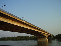
Lafranconi Bridge
Lafranconi Bridge is a concrete motorway bridge in Bratislava, Slovakia, located on the D2 motorway. It was built in 1985-1991, with its right half opened in 1990 and the rest in 1992. It is 766 m long , and has a 30 m wide four-lane motorway. There are lanes for cyclists and pedestrians as well. ...
in Bratislava and the junction with D1 motorway junction and temporary end in Petržalka
Petržalka
Petržalka ) is the largest borough of Bratislava, the capital of Slovakia. Situated on the right bank of the river Danube, it is home to approximately 150,000 people.-History:Historical records of Petržalka exist from 1225...
in the years 1985 - 1991 and after its opening, construction stopped for five years. It continues further since 1996, with the sections from temporary end to Hungary and Austria, with all being opened in 1998 and with the 8.5 km segment from D4 junction to the Hungarian border being widened in 2002. Today, the motorway is complete, with the last 3 km in Bratislava with the only tunnel in its entire length, the Sitina Tunnel
Sitina Tunnel
The Sitina Tunnel is a motorway tunnel in Bratislava, Slovakia on the D2 motorway at the "Lamačská cesta - Staré grunty" section. The tunnel goes under the Little Carpathians forest...
opened on 24 June 2007.
Sections of the motorway
| Section | Length | Opening |
|---|---|---|
| Slovakia/Czechia border - Kúty Kúty Kúty, is a village and municipality in Senica District in the Trnava Region of western Slovakia.-Geography:The municipality lies at an altitude of 156 metres and covers an area of 27.158 km²... |
4,5 km | November 1980 |
| Kúty Kúty Kúty, is a village and municipality in Senica District in the Trnava Region of western Slovakia.-Geography:The municipality lies at an altitude of 156 metres and covers an area of 27.158 km²... - Malacky Malacky Malacky is a town and municipality in western Slovakia around 35 km north from capital Bratislava. From the second half of the 10th century until 1918, it was part of the Kingdom of Hungary... |
27,2 km | July 1977 |
| Malacky - Bratislava Bratislava Bratislava is the capital of Slovakia and, with a population of about 431,000, also the country's largest city. Bratislava is in southwestern Slovakia on both banks of the Danube River. Bordering Austria and Hungary, it is the only national capital that borders two independent countries.Bratislava... , Lamač Lamac Lamač is the smallest borough of Bratislava, and part of the Bratislava IV district.The first written record of the German settlement dates to 1240. The German village was destroyed during the first siege of vienna by Turkish troops. Croats fleeing from the Ottomans in the south settled this area... |
29,3 km | November 1973 |
| Bratislava, Lamač - Bratislava, Staré grunty | 3,1 km | 24 June 2007 |
| Bratislava, Staré grunty - Bratislava, Viedenská cesta | 2,6 km | 1990/widened 1992 |
| Bratislava, Viedenská cesta - Bratislava, Jarovce Jarovce Jarovce is a small borough of Bratislava, Slovakia.- History :The village was first mentioned in 1208 under the name Ban. During the Ottoman wars, many Croats settled here in the 16th century . They are still a strong minority... |
4,9 km | 2002 |
| Bratislava, Jarovce - Čunovo Cunovo Čunovo is a small part of Bratislava, Slovakia, in the southern area near the Hungarian border. It is located close to the Gabčíkovo - Nagymaros Dams.- History :... on the Slovakia/Hungary border |
8,5 km | 1998/widened 2002 |