
.gif)
Highway 68 (Ontario)
Encyclopedia
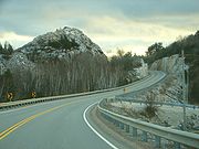
Highway 68 was a provincially maintained highway on Manitoulin Island
, linking the island to the mainland
. It was connected to the rest of the network by Highway 17
in McKerrow. The road was built in the 1920s as a trunk road for the Department of Northern Development (later merged into the Department of Highways, today's Ministry of Transportation
), but was formed as a provincial highway in 1937, as the only Kings Highway on the island. Highway 68 stretched from Espanola
in the north, through the towns of Little Current and Manitowaning south to South Baymouth.
 While the road was re-aligned somewhat throughout its history (many of the re-alignments took place in the late 1950s and early 1960s), and its overall path has not changed, its length has varied considerably during re-alignments, creeping as high as 130 km during the 1960s, before settling back down to its current value of around 116 km. Some former alignments (such as "Devil's Elbow Road") are still in use. The road was fully paved by 1973, making this road one of the last Kings Highways in the province to be paved in its entirety (with the last Kings Highway to be paved being Highway 129
in 1983).
In 1980, the road was eliminated as a separate highway, when the designation of Highway 6
was applied to Highway 68's entire length. The two discontinuous sections of Highway 6 are currently linked only by a privately-operated ferry, the Chi-Cheemaun
, which runs daily from May to October from South Baymouth to Tobermory
, across Georgian Bay
.
Manitoulin Island
Manitoulin Island is a Canadian island in Lake Huron, in the province of Ontario. It is the largest island in a freshwater lake in the world. In addition to the historic Anishinaabe and European settlement of the island, archeological discoveries at Sheguiandah have demonstrated Paleo-Indian and...
, linking the island to the mainland
Mainland
Mainland is a name given to a large landmass in a region , or to the largest of a group of islands in an archipelago. Sometimes its residents are called "Mainlanders"...
. It was connected to the rest of the network by Highway 17
Highway 17 (Ontario)
King's Highway 17, more commonly known as Highway 17, is a provincially maintained highway and the primary route of the Trans-Canada Highway through the Canadian province of Ontario. It begins at the Manitoba border west of Kenora and ends south of Arnprior at the western terminus of Highway 417, ...
in McKerrow. The road was built in the 1920s as a trunk road for the Department of Northern Development (later merged into the Department of Highways, today's Ministry of Transportation
Ministry of Transportation (Ontario)
The Ministry of Transportation of Ontario is the provincial ministry of the government of Ontario which is responsible for transport infrastructure and related law in Ontario. The ministry traces its roots back over a century to the 1890s, when the province began training Provincial Road Building...
), but was formed as a provincial highway in 1937, as the only Kings Highway on the island. Highway 68 stretched from Espanola
Espanola, Ontario
Espanola is a town in Northern Ontario, Canada, and is the seat of Sudbury District. It is situated on the Spanish River, approximately 70 kilometres west of downtown Sudbury, and just south of the junction of Highway 6 and Highway 17.- History :The name "Espanola" has been attributed to a story...
in the north, through the towns of Little Current and Manitowaning south to South Baymouth.
Highway 129 (Ontario)
King's Highway 129, commonly referred to as Highway 129, is a provincially maintained highway in the Canadian province of Ontario. Located in the Algoma and Sudbury districts, the highway extends for from a junction with Highway 17 in Thessalon to the town of Chapleau, just north of Highway 101...
in 1983).
In 1980, the road was eliminated as a separate highway, when the designation of Highway 6
Highway 6 (Ontario)
King's Highway 6, also known as Highway 6, is a provincially maintained highway in the Canadian province of Ontario. It crosses a distance of between Port Dover on the north shore of Lake Erie and Espanola on the northern shore of Lake Huron, ending at the Trans-Canada Highway in McKerrow.- Port...
was applied to Highway 68's entire length. The two discontinuous sections of Highway 6 are currently linked only by a privately-operated ferry, the Chi-Cheemaun
Chi-Cheemaun
MS Chi-Cheemaun is a passenger and car ferry in Ontario, Canada, which traverses Lake Huron between Tobermory on Bruce Peninsula and South Baymouth on Manitoulin Island. The ferry connects the two geographically separate portions of Highway 6 and is the vessel that replaced MS Norgoma and SS...
, which runs daily from May to October from South Baymouth to Tobermory
Tobermory, Ontario
Tobermory is a small community located at the northern tip of the Bruce Peninsula in the municipality of Northern Bruce Peninsula, Ontario, Canada. It is 300 km northwest of Toronto...
, across Georgian Bay
Georgian Bay
Georgian Bay is a large bay of Lake Huron, located entirely within Ontario, Canada...
.