
.gif)
Highway 119 (Wisconsin)
Encyclopedia
State Trunk Highway 119 (often called Highway 119, STH 119 or WIS 119), better known as the "Airport Spur", is a connector freeway in Milwaukee, Wisconsin
. The 1.89 miles (3 km) freeway connects Interstate Highway 94 to General Mitchell International Airport
. STH 119 has had many different iterations dating back to 1919, and since has had five other variations including the modern day route. These different roads were short lived but were located throughout the state of Wisconsin in the Milwaukee area
, Manitowoc
and Green Bay
.
The current route starts at Interstate 94
and has just one more exit at Wisconsin Highway 38 (Howell Avenue) before ending at the airport. Until 2007, STH 119 was not signed but was commissioned and appeared on highway maps. After travelers in the area became confused because the route was not signed, officials decided to change the exit signs from I-94 in order to include the highway. There have been plans to rebuild STH 119 as part of a larger project in the Milwaukee area.
/U.S. Highway 41 exit number 318 and continues eastbound as a two-lane freeway. It progresses through a mainly residential area for most of its length. There are multiple official signs about General Mitchell International Airport
along the route going eastbound which mainly detail airport parking. At the terminus the speed limit drops to 35 miles per hour (56.3 km/h). The road terminates at Wisconsin Highway 38 giving an option to either exit onto that highway or continue into the airport.
and continuing to downtown Milwaukee. In 1930 the route was "decommissioned" leaving part of the road in local control and the other becoming a piece of U.S. 16. In 1931 State Highway 119 reappeared in the Manitowoc
area. In 1956 U.S. 141 ended up supplanting STH 119, leading the short route to be taken into local control. STH 119 was commissioned again in 1968 in Green Bay
. Like its predecessors this variation of the route was eventually decommissioned and replaced by a BUS US-41 designation.
 As described in a 1974 Milwaukee County memorandum, the modern route was originally planned as one of five new freeways. It was the only one ever built. The road was designed to offer more support to a growing General Mitchell International Airport
and facilitate travel between the airport and Interstate 94
. The project received multiple criticism
s, such as the relocation of a historic B-25 bomber and the resignation of a highway official. This along with other factors prompted the Milwaukee Common Council to oppose the new freeway, and instead suggest a new airport be built outside Milwaukee County. The new airport was not built and in 1978 the freeway was completed.
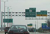
On April 10, 2007, the Wisconsin DOT
changed the exit signs from I-94 for the Airport spur to include a state highway shield with the number 119, officially designating the highway as State Trunk Highway 119. According to Wisconsin DOT official Tom Heydel (quoted in the Milwaukee Journal Sentinel's Road Warrior column), the signs were recently changed after drivers asked why the exit wasn't labeled as Highway 119. Since publication of the 1983–84 official map, state highway maps have labeled the route as Highway 119. However, travelers had trouble finding the road, which was not identified as Highway 119 by highway signs. As part of the rebuilding of the I-94/US-41 corridor there have been plans to rebuild
the route into "less of a freeway and more of a gateway." According to Robert Gutierrez a project supervisor, the plan would be to turn the freeway into "a boulevard of sorts." This project is slated to begin in 2009 and last until 2010.
Milwaukee, Wisconsin
Milwaukee is the largest city in the U.S. state of Wisconsin, the 28th most populous city in the United States and 39th most populous region in the United States. It is the county seat of Milwaukee County and is located on the southwestern shore of Lake Michigan. According to 2010 census data, the...
. The 1.89 miles (3 km) freeway connects Interstate Highway 94 to General Mitchell International Airport
General Mitchell International Airport
General Mitchell International Airport is a county-owned public airport located five miles south of the central business district of Milwaukee, a city in Milwaukee County, Wisconsin, United States....
. STH 119 has had many different iterations dating back to 1919, and since has had five other variations including the modern day route. These different roads were short lived but were located throughout the state of Wisconsin in the Milwaukee area
Milwaukee metropolitan area
The Milwaukee–Racine–Waukesha metropolitan area is an urban area identified by the U.S. Census Bureau containing five counties in southeastern Wisconsin: Milwaukee, Waukesha, Racine, Washington and Ozaukee...
, Manitowoc
Manitowoc, Wisconsin
Manitowoc is a city in and the county seat of Manitowoc County, Wisconsin, United States. The city is located on Lake Michigan at the mouth of the Manitowoc River. According to the 2000 census, Manitowoc had a population of 34,053, with over 50,000 residents in the surrounding communities...
and Green Bay
Green Bay, Wisconsin
Green Bay is a city in and the county seat of Brown County in the U.S. state of Wisconsin, located at the head of Green Bay, a sub-basin of Lake Michigan, at the mouth of the Fox River. It has an elevation of above sea level and is located north of Milwaukee. As of the 2010 United States Census,...
.
The current route starts at Interstate 94
Interstate 94
Interstate 94 is the northernmost east–west Interstate Highway, connecting the Great Lakes and Intermountain regions of the United States. I-94's western terminus is in Billings, Montana at a junction with Interstate 90; its eastern terminus is the U.S...
and has just one more exit at Wisconsin Highway 38 (Howell Avenue) before ending at the airport. Until 2007, STH 119 was not signed but was commissioned and appeared on highway maps. After travelers in the area became confused because the route was not signed, officials decided to change the exit signs from I-94 in order to include the highway. There have been plans to rebuild STH 119 as part of a larger project in the Milwaukee area.
Route description
STH 119 starts at Interstate 94Interstate 94
Interstate 94 is the northernmost east–west Interstate Highway, connecting the Great Lakes and Intermountain regions of the United States. I-94's western terminus is in Billings, Montana at a junction with Interstate 90; its eastern terminus is the U.S...
/U.S. Highway 41 exit number 318 and continues eastbound as a two-lane freeway. It progresses through a mainly residential area for most of its length. There are multiple official signs about General Mitchell International Airport
General Mitchell International Airport
General Mitchell International Airport is a county-owned public airport located five miles south of the central business district of Milwaukee, a city in Milwaukee County, Wisconsin, United States....
along the route going eastbound which mainly detail airport parking. At the terminus the speed limit drops to 35 miles per hour (56.3 km/h). The road terminates at Wisconsin Highway 38 giving an option to either exit onto that highway or continue into the airport.
History
State Trunk Highway 119 has had many different versions throughout different areas of Wisconsin. The first route debuted in 1919 as a short connector trunkline along the present-day route of Wisconsin Highway 83; within a few years this routing was replaced. The next version of the road was completed in 1924 starting at Wisconsin Highway 19 in PewaukeePewaukee, Wisconsin
Pewaukee is a city in Waukesha County, Wisconsin. The population was 11,783 at the 2000 census. The city was incorporated from what was formerly the Town of Pewaukee. The Village of Pewaukee, which was incorporated out of the town before it incorporated as a city, is surrounded by the city...
and continuing to downtown Milwaukee. In 1930 the route was "decommissioned" leaving part of the road in local control and the other becoming a piece of U.S. 16. In 1931 State Highway 119 reappeared in the Manitowoc
Manitowoc, Wisconsin
Manitowoc is a city in and the county seat of Manitowoc County, Wisconsin, United States. The city is located on Lake Michigan at the mouth of the Manitowoc River. According to the 2000 census, Manitowoc had a population of 34,053, with over 50,000 residents in the surrounding communities...
area. In 1956 U.S. 141 ended up supplanting STH 119, leading the short route to be taken into local control. STH 119 was commissioned again in 1968 in Green Bay
Green Bay, Wisconsin
Green Bay is a city in and the county seat of Brown County in the U.S. state of Wisconsin, located at the head of Green Bay, a sub-basin of Lake Michigan, at the mouth of the Fox River. It has an elevation of above sea level and is located north of Milwaukee. As of the 2010 United States Census,...
. Like its predecessors this variation of the route was eventually decommissioned and replaced by a BUS US-41 designation.
General Mitchell International Airport
General Mitchell International Airport is a county-owned public airport located five miles south of the central business district of Milwaukee, a city in Milwaukee County, Wisconsin, United States....
and facilitate travel between the airport and Interstate 94
Interstate 94
Interstate 94 is the northernmost east–west Interstate Highway, connecting the Great Lakes and Intermountain regions of the United States. I-94's western terminus is in Billings, Montana at a junction with Interstate 90; its eastern terminus is the U.S...
. The project received multiple criticism
Criticism
Criticism is the judgement of the merits and faults of the work or actions of an individual or group by another . To criticize does not necessarily imply to find fault, but the word is often taken to mean the simple expression of an objection against prejudice, or a disapproval.Another meaning of...
s, such as the relocation of a historic B-25 bomber and the resignation of a highway official. This along with other factors prompted the Milwaukee Common Council to oppose the new freeway, and instead suggest a new airport be built outside Milwaukee County. The new airport was not built and in 1978 the freeway was completed.
On April 10, 2007, the Wisconsin DOT
Wisconsin Department of Transportation
The Wisconsin Department of Transportation, abbreviated as WisDOT, is a governmental agency of the U.S. state of Wisconsin responsible for planning, building and maintaining the state's highways...
changed the exit signs from I-94 for the Airport spur to include a state highway shield with the number 119, officially designating the highway as State Trunk Highway 119. According to Wisconsin DOT official Tom Heydel (quoted in the Milwaukee Journal Sentinel's Road Warrior column), the signs were recently changed after drivers asked why the exit wasn't labeled as Highway 119. Since publication of the 1983–84 official map, state highway maps have labeled the route as Highway 119. However, travelers had trouble finding the road, which was not identified as Highway 119 by highway signs. As part of the rebuilding of the I-94/US-41 corridor there have been plans to rebuild
Rebuild
"Rebuild" is a song written by Jon Foreman of Switchfoot and Matt Thiessen of Relient K. The song was written in conjunction with the bands' 2007 Appetite for Construction Tour, featuring members from all three bands on tour, Switchfoot, Relient K, and Ruth...
the route into "less of a freeway and more of a gateway." According to Robert Gutierrez a project supervisor, the plan would be to turn the freeway into "a boulevard of sorts." This project is slated to begin in 2009 and last until 2010.
Exit list
| Location | Mile | Destinations | Notes |
|---|---|---|---|
| Milwaukee | 0.00 | , Chicago Chicago Chicago is the largest city in the US state of Illinois. With nearly 2.7 million residents, it is the most populous city in the Midwestern United States and the third most populous in the US, after New York City and Los Angeles... |
|
| 1.89 | Road continues under local control to General Mitchell International Airport General Mitchell International Airport General Mitchell International Airport is a county-owned public airport located five miles south of the central business district of Milwaukee, a city in Milwaukee County, Wisconsin, United States.... . |