
High Tove
Encyclopedia
High Tove is a fell
in the English Lake District
, close to the geographical centre of the Cumbria
n hills. It forms part of the watershed between the Derwentwater and Thirlmere
catchments, a ridge running broadly north-south.
, High Tove is an outlier of High Seat
. It is separated from its taller northern neighbour by the Peewits, an extremely boggy depression. The ridge moves on south across further upland marsh towards Ullscarf
, passing over the three rocky (and dry) outcrops of Middle Crag, Shivery Knott and Watendlath Fell (summit unnamed on Ordnance Survey maps). Armboth Fell
lies to the south east of High Tove, connected to the ridge by a broad heathery saddle.
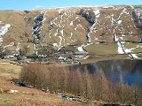
High Tove covers around one and a half miles of the north-south ridge, which is approximately a mile in width. It is bounded on the west by Watendlath Gill and its main feeder, Blea Tarn Gill. These flow to Watendlath Tarn, a popular beauty spot. The tarn
is available for private fishing, being well stocked with trout
. It holds a wide selection of flora, including water lilies
and is at least 50 ft deep. Fisher and Launchy Gills provide the eastern boundaries of High Tove, flowing north and south around Armboth Fell respectively. Both are feeders of Thirlmere.
with breccia
.
, which in Wainwright's words offers a seat to travellers who wish to pour the water out of their boots.
The views are good to the either side, the Helvellyn range
nearby to the east and a wide selection of major fells visible on the opposite flank of the ridge. Higher neighbours obstruct the view to north and south.
Fell
“Fell” is a word used to refer to mountains, or certain types of mountainous landscape, in Scandinavia, the Isle of Man, and parts of northern England.- Etymology :...
in the English Lake District
Lake District
The Lake District, also commonly known as The Lakes or Lakeland, is a mountainous region in North West England. A popular holiday destination, it is famous not only for its lakes and its mountains but also for its associations with the early 19th century poetry and writings of William Wordsworth...
, close to the geographical centre of the Cumbria
Cumbria
Cumbria , is a non-metropolitan county in North West England. The county and Cumbria County Council, its local authority, came into existence in 1974 after the passage of the Local Government Act 1972. Cumbria's largest settlement and county town is Carlisle. It consists of six districts, and in...
n hills. It forms part of the watershed between the Derwentwater and Thirlmere
Thirlmere
Thirlmere is a reservoir in the Borough of Allerdale in Cumbria and the English Lake District. It runs roughly south to north, with a dam at the northern end, and is bordered on the eastern side by the A591 road and on the western side by a minor road....
catchments, a ridge running broadly north-south.
Topography
Sitting astride the spine of the Central FellsCentral Fells
The Central Fells are a group of hills in the English Lake District. Reaching their highest point at High Raise , they occupy a broad area to the east of Borrowdale. Perhaps unexpectedly the Central Fells are generally lower than the surrounding hills, the Lake District's general dome-like...
, High Tove is an outlier of High Seat
High Seat (Lake District)
High Seat is a fell in the centre of the English Lake District. Despite being below 2,000 ft it is the highest point for about 5 miles in any direction; a consequence of the curious fact that the centre of the district is lower than the surrounding parts.-Topography:The main watershed of...
. It is separated from its taller northern neighbour by the Peewits, an extremely boggy depression. The ridge moves on south across further upland marsh towards Ullscarf
Ullscarf
Ullscarf is a fell in the English Lake District close to the geographical centre of the Cumbrian hills. It forms part of the watershed between the Derwentwater and Thirlmere catchments, a ridge running broadly north-south.-Topography:...
, passing over the three rocky (and dry) outcrops of Middle Crag, Shivery Knott and Watendlath Fell (summit unnamed on Ordnance Survey maps). Armboth Fell
Armboth Fell
Armboth Fell is a fell in the English Lake District, believed by Alfred Wainwright to lie in the very centre of Lakeland. The fell is a domed plateau, three-quarters of a mile across, jutting out to the east of the Derwentwater-Thirlmere watershed. The fell is wet underfoot, with large areas clad...
lies to the south east of High Tove, connected to the ridge by a broad heathery saddle.
High Tove covers around one and a half miles of the north-south ridge, which is approximately a mile in width. It is bounded on the west by Watendlath Gill and its main feeder, Blea Tarn Gill. These flow to Watendlath Tarn, a popular beauty spot. The tarn
Tarn (lake)
A tarn is a mountain lake or pool, formed in a cirque excavated by a glacier. A moraine may form a natural dam below a tarn. A corrie may be called a cirque.The word is derived from the Old Norse word tjörn meaning pond...
is available for private fishing, being well stocked with trout
Trout
Trout is the name for a number of species of freshwater and saltwater fish belonging to the Salmoninae subfamily of the family Salmonidae. Salmon belong to the same family as trout. Most salmon species spend almost all their lives in salt water...
. It holds a wide selection of flora, including water lilies
Nelumbo
Nelumbo is a genus of aquatic plants with large, showy flowers resembling water lilies, commonly known as lotus. The generic name is derived from the Sinhalese word Nelum. There are only two known living species in the genus. The sacred lotus is native to Asia, and is the better known of the two...
and is at least 50 ft deep. Fisher and Launchy Gills provide the eastern boundaries of High Tove, flowing north and south around Armboth Fell respectively. Both are feeders of Thirlmere.
Geology
The summit is an island outcrop of the Thirlmere Member in a sea of drift deposits. The Thirlmere Member comprises welded rhyodacitic tuffTuff
Tuff is a type of rock consisting of consolidated volcanic ash ejected from vents during a volcanic eruption. Tuff is sometimes called tufa, particularly when used as construction material, although tufa also refers to a quite different rock. Rock that contains greater than 50% tuff is considered...
with breccia
Breccia
Breccia is a rock composed of broken fragments of minerals or rock cemented together by a fine-grained matrix, that can be either similar to or different from the composition of the fragments....
.
Ascents
A bridleway from Watendlath to Armboth crosses the ridge. Unusually it keeps to the summit rather than a depression, in an attempt to avoid wet ground. A further path runs along the watershed, accompanied by a wire fence. This can prove useful for crossing the worst of the bogs.Summit and view
The top has a large cairnCairn
Cairn is a term used mainly in the English-speaking world for a man-made pile of stones. It comes from the or . Cairns are found all over the world in uplands, on moorland, on mountaintops, near waterways and on sea cliffs, and also in barren desert and tundra areas...
, which in Wainwright's words offers a seat to travellers who wish to pour the water out of their boots.
The views are good to the either side, the Helvellyn range
Helvellyn range
Helvellyn range is the name given to a part of the Eastern Fells in the English Lake District, fell being the local word for hill. The name comes from Helvellyn, the highest point of the group....
nearby to the east and a wide selection of major fells visible on the opposite flank of the ridge. Higher neighbours obstruct the view to north and south.