
Heber Down Conservation Area
Encyclopedia
Heber Down Conservation Area is located in Whitby, Ontario
and is owned and operated by Central Lake Ontario Conservation Authority
. It is located within the Lynde Creek drainage basin
; it is a part of the provincially significant Heber Down Wetland Complex. The area is composed of two types of broad terrain units: a valley formed by the creek and the Glacial Lake Iroquois
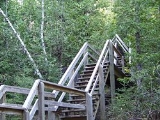
beach. The area provides such recreational activities as hiking, mountain biking, picnicking, and fishing.
 The sandy and gravelly Glacial Lake Iroquois beach is a remnant of the Wisconsin glaciation. It was deposited by Lake Iroquois, the precursor to Lake Ontario
, about 12,500 year ago. As the lake was shrinking, a line of beach deposits was receding as well, resulting in deposition of sand over the layers of silt and clay that were deposited when the lake was deeper. Following the final recession of the lake, the exposed sand layers were soaked by rainfall. Due to impervious layers underneath, high water table
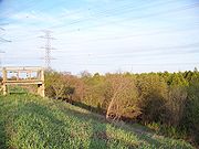
resulted in formation of large areas of swamps and marshes. Eastern parts of the conservation area are occupied by treed swamps and thicket
swamps under the power transmission lines
, where trees were removed.
The western portions of the area are characterized by the steeply incised valley of the Lynde Creek. At places where it cuts across the sandy Lake Iroquois beach, groundwater
seeps
occur, providing an ecological niche
for plants growing on the valley's walls.
, incising the area, was used by horse thieves
as a layover
. Local inhabitants interpreted the noises produced by the thieves and horses in a superstitious way: they assumed that the Devil
was holding court there. Hence, the gully was named Devil's Den.
During the 1910s, the Canadian Northern Railway
constructed a new line to provide passenger service from Toronto
to Trenton
. A bridge over the Devil's Den was completed in March 1910. While the bridge itself has been demolished, remains of cement abutment
s and piers
that served as a foundation of the bridge can still be found in the area.
Whitby, Ontario
Whitby is a town in Durham Region. Whitby is located in Southern Ontario east of Toronto on the north shore of Lake Ontario, and is home to the headquarters of Durham Region...
and is owned and operated by Central Lake Ontario Conservation Authority
Central Lake Ontario Conservation Authority
Central Lake Ontario Conservation Authority , is a conservation authority established under the Conservation Authorities Act of Ontario in 1958...
. It is located within the Lynde Creek drainage basin
Drainage basin
A drainage basin is an extent or an area of land where surface water from rain and melting snow or ice converges to a single point, usually the exit of the basin, where the waters join another waterbody, such as a river, lake, reservoir, estuary, wetland, sea, or ocean...
; it is a part of the provincially significant Heber Down Wetland Complex. The area is composed of two types of broad terrain units: a valley formed by the creek and the Glacial Lake Iroquois
Glacial Lake Iroquois
Glacial Lake Iroquois was a prehistoric proglacial lake that existed at the end of the last ice age approximately 13,000 years ago.The lake was essentially an enlargement of the present Lake Ontario that formed because the St. Lawrence River downstream from the lake was blocked by the ice sheet...
beach. The area provides such recreational activities as hiking, mountain biking, picnicking, and fishing.
Landform and vegetation
Lake Ontario
Lake Ontario is one of the five Great Lakes of North America. It is bounded on the north and southwest by the Canadian province of Ontario, and on the south by the American state of New York. Ontario, Canada's most populous province, was named for the lake. In the Wyandot language, ontarío means...
, about 12,500 year ago. As the lake was shrinking, a line of beach deposits was receding as well, resulting in deposition of sand over the layers of silt and clay that were deposited when the lake was deeper. Following the final recession of the lake, the exposed sand layers were soaked by rainfall. Due to impervious layers underneath, high water table
Water table
The water table is the level at which the submarine pressure is far from atmospheric pressure. It may be conveniently visualized as the 'surface' of the subsurface materials that are saturated with groundwater in a given vicinity. However, saturated conditions may extend above the water table as...
resulted in formation of large areas of swamps and marshes. Eastern parts of the conservation area are occupied by treed swamps and thicket
Thicket
A thicket is a very dense stand of trees or tall shrubs, often dominated by only one or a few species, to the exclusion of all others. They may be formed by species that shed large amounts of highly viable seeds that are able to germinate in the shelter of the maternal plants.In some conditions the...
swamps under the power transmission lines
Electric power transmission
Electric-power transmission is the bulk transfer of electrical energy, from generating power plants to Electrical substations located near demand centers...
, where trees were removed.
The western portions of the area are characterized by the steeply incised valley of the Lynde Creek. At places where it cuts across the sandy Lake Iroquois beach, groundwater
Groundwater
Groundwater is water located beneath the ground surface in soil pore spaces and in the fractures of rock formations. A unit of rock or an unconsolidated deposit is called an aquifer when it can yield a usable quantity of water. The depth at which soil pore spaces or fractures and voids in rock...
seeps
Seep (hydrology)
A Seep is a moist or wet place where water, usually groundwater, reaches the earth's surface from an underground aquifer.-Description:Seeps are usually not of sufficient volume to be flowing beyond their above-ground location. They are part of the limnology-geomorphology system...
occur, providing an ecological niche
Ecological niche
In ecology, a niche is a term describing the relational position of a species or population in its ecosystem to each other; e.g. a dolphin could potentially be in another ecological niche from one that travels in a different pod if the members of these pods utilize significantly different food...
for plants growing on the valley's walls.
Cultural history
In the late 19th and early 20th century, a deep gullyGully
A gully is a landform created by running water, eroding sharply into soil, typically on a hillside. Gullies resemble large ditches or small valleys, but are metres to tens of metres in depth and width...
, incising the area, was used by horse thieves
Horse thief
-United States:The term horse thief came into great popularity in the U.S. during the 19th century. During that time the Great Plains states, Texas, and other western states were sparsely populated and negligibly policed. As farmers tilled the land and migrants headed west through the Great...
as a layover
Layover
In transportation, a layover, also known as lays over or stopover, is some form of a break between parts of a single trip.-In mass transit:...
. Local inhabitants interpreted the noises produced by the thieves and horses in a superstitious way: they assumed that the Devil
Devil
The Devil is believed in many religions and cultures to be a powerful, supernatural entity that is the personification of evil and the enemy of God and humankind. The nature of the role varies greatly...
was holding court there. Hence, the gully was named Devil's Den.
During the 1910s, the Canadian Northern Railway
Canadian Northern Railway
The Canadian Northern Railway is a historic Canadian transcontinental railway. At its demise in 1923, when it was merged into the Canadian National Railway , the CNoR owned a main line between Quebec City and Vancouver via Ottawa, Winnipeg, and Edmonton.-Manitoba beginnings:CNoR had its start in...
constructed a new line to provide passenger service from Toronto
Toronto
Toronto is the provincial capital of Ontario and the largest city in Canada. It is located in Southern Ontario on the northwestern shore of Lake Ontario. A relatively modern city, Toronto's history dates back to the late-18th century, when its land was first purchased by the British monarchy from...
to Trenton
Trenton, Ontario
Trenton is a community in Southern Ontario in the municipality of Quinte West, Ontario, Canada. Located on the Bay of Quinte, it is the main population centre in Quinte West....
. A bridge over the Devil's Den was completed in March 1910. While the bridge itself has been demolished, remains of cement abutment
Abutment
An abutment is, generally, the point where two structures or objects meet. This word comes from the verb abut, which means adjoin or having common boundary. An abutment is an engineering term that describes a structure located at the ends of a bridge, where the bridge slab adjoins the approaching...
s and piers
Pier (architecture)
In architecture, a pier is an upright support for a superstructure, such as an arch or bridge. Sections of wall between openings function as piers. The simplest cross section of the pier is square, or rectangular, although other shapes are also common, such as the richly articulated piers of Donato...
that served as a foundation of the bridge can still be found in the area.