

Heaphy Track
Encyclopedia


South Island
The South Island is the larger of the two major islands of New Zealand, the other being the more populous North Island. It is bordered to the north by Cook Strait, to the west by the Tasman Sea, to the south and east by the Pacific Ocean...
of New Zealand
New Zealand
New Zealand is an island country in the south-western Pacific Ocean comprising two main landmasses and numerous smaller islands. The country is situated some east of Australia across the Tasman Sea, and roughly south of the Pacific island nations of New Caledonia, Fiji, and Tonga...
. It is located within the Kahurangi National Park
Kahurangi National Park
Kahurangi National Park is a national park in the northwest of the South Island of New Zealand. It was gazetted in 1996 and covers 4,520 km². It is the second largest of New Zealand's fourteen national parks...
and classified as one of New Zealand's nine Great Walks
New Zealand Great Walks
The New Zealand Great Walks are a set of popular tramping tracks. They are New Zealand's premier tracks, through areas of some of the best scenery in the country...
by the Department of Conservation
New Zealand Department of Conservation
The Department of Conservation , commonly known by its acronym, "DOC", is the state sector organisation which deals with the conservation of New Zealand’s natural and historic heritage...
. Named after Charles Heaphy
Charles Heaphy
Major Charles Heaphy VC was a New Zealand explorer and a recipient of the Victoria Cross, the highest and most prestigious military award for gallantry in the face of the enemy that can be awarded to British and Commonwealth forces....
, the track is 82 km long and is usually walked in four or five days. From May 2011, mountain bike access will be permitted again.
History
Māori tribes are known to have settled along the lower course of the Heaphy RiverHeaphy River
The Heaphy River is a river of the northwestern South Island of New Zealand. It flows through Kahurangi National Park, rising on the northern slopes of Amohia Peak and initially flowing northwest before turning southwest to reach the Tasman Sea 30 kilometres north of Karamea...
as early as in the 16th century. Evidence has been found that the area crossed by today's Heaphy Track had been explored in these ancient times by Māoris seeking greenstone (pounamu) in the Gouland Downs sector.
The first visit of the area by persons whose names were recorded took place in 1846, when Charles Heaphy, Thomas Brunner
Thomas Brunner
Thomas Brunner was an English-born surveyor and explorer remembered for his exploration of the western coastal areas of New Zealand's South Island....
and their Māori guide Kehu and supported by another guide Etau explored the coastal sector of the track.
The first recorded crossing of the whole range approximately along today's path took place in 1859, by a European gold miner named Aldrige; another visit is recorded in 1860, by James MacKay and John Clark.
In the following years of goldrush, the area was extensively visited for gold, and the track was definitely laid out by various prospectors and surveyors, among which JB Saxon in 1888.
But there was no gold to be found in the sector. After thirty years, prospecting came to an end and the track was virtually forgotten after 1900, becoming overgrown and seldom used except by an occasional hunter.
The creation of the North-west Nelson Forest Park in 1965, that was to become Kahurangi National Park
Kahurangi National Park
Kahurangi National Park is a national park in the northwest of the South Island of New Zealand. It was gazetted in 1996 and covers 4,520 km². It is the second largest of New Zealand's fourteen national parks...
in 1996, led to the rediscovery and improvement of the track, which is now tramped by thousands of people every year.
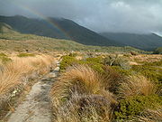
Landscape along the track
The Heaphy track is renowned for the variety of landscapes crossed; every 20 km section is significantly different from the previous one.Walking the path east to west, the journey begins through a forest where beech
Beech
Beech is a genus of ten species of deciduous trees in the family Fagaceae, native to temperate Europe, Asia and North America.-Habit:...
es (Nothofagus
Nothofagus
Nothofagus, also known as the southern beeches, is a genus of 35 species of trees and shrubs native to the temperate oceanic to tropical Southern Hemisphere in southern South America and Australasia...
) are dominant. Some zigzags lead to the highest point of the track, at 915 m, with good views to the surrounding mountains.
From there on, tussocks replace forests, and the Gouland Downs are entered soon, a large featureless area drained by many rivers, with swingbridges helping to cross them when they are in spate.
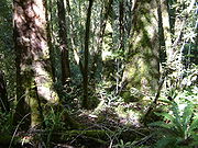
Now woody patches regain over tussock moors; near Gouland Downs Hut, beeches covered by thick moss are reminiscent of the wettest forests of southern New Zealand.
After several kilometers of alternating tussock downs and bush, MacKay Hut is reached, with broad views reaching to the Tasman Sea
Tasman Sea
The Tasman Sea is the large body of water between Australia and New Zealand, approximately across. It extends 2,800 km from north to south. It is a south-western segment of the South Pacific Ocean. The sea was named after the Dutch explorer Abel Janszoon Tasman, the first recorded European...
. There begins a long descent through the bush. This time podocarps
Podocarpaceae
Podocarpaceae is a large family of mainly Southern Hemisphere conifers, comprising about 156 species of evergreen trees and shrubs. It contains 19 genera if Phyllocladus is included and if Manoao and Sundacarpus are recognized....
are dominant, including impressive large rimu
Dacrydium cupressinum
Dacrydium cupressinum, commonly known as rimu, is a large evergreen coniferous tree endemic to the forests of New Zealand. It is a member of the southern conifer group, the podocarps. The former name "red pine" has fallen out of common use....
trees.
At the end of this descent, the Heaphy River valley is reached at Lewis Hut. The river course is followed for 8 km of peaceful flat walk, crossing the Heaphy River and several affluents on long swingbridges. This leads to discovering the nikau palm forest, which is probably the most striking feature of the Heaphy Track.
The seashore is reached at Heaphy Hut, at the mouth of the Heaphy River. The last section is a coastal walk, alternating sandy beaches beaten by the waves and forest sections, where nikau palms dominate.
Roading debate
Repeated attempts, from the 1950s to the 1980s, by the South Island Local Bodies Association to have the Ministry of WorksNew Zealand Ministry of Works
The New Zealand Ministry of Works, formerly the Department of Public Works and sometimes referred to as the Public Works Department or PWD, was founded in 1876 and disestablished and privatised in 1988...
build the road were made. The Ministry considered the road proposal to be too expensive and did not view it as a priority.
The famed coastal strip with its iconic nikau
Nikau
Nikau is a palm tree, the only palm endemic to New Zealand.-Etymology:Nīkau is a Māori word; in the closely related Eastern Polynesian languages of the tropical Pacific, it refers to the fronds or the midrib of the coconut palm.- Distribution:The Nikau palm is the only palm species endemic to...
palm groves was particularly at risk with any road construction. Even with simple track construction at Crayfish Point many years ago, the overall effect was to see major slips carry the groves into the sea. Those fighting roading proposals felt this could be the result along the very narrow, palm-covered coastal strip if road construction were to take place.
Up until the 1980s the threats to the track were real, as the local population and councils largely supported roading in the belief that a "tourist circuit" of the South Island would increase the access and popularity of the area. The track proponents argued the damage could never be justified and that the popularity would come more in the form of people being drawn to the area for days rather than those who would drive through and use "comfort stops".
The campaign to "save" the Track and the popular support the conservation effort gathered over many years became pivotal in changing the attitude of the authorities to environmental matters. The New Zealand Government instigated many changes to curb unnecessary environmental destruction.
Following the major campaigns, track use grew substantially. Of more recent times track use has moderated to a point where it now forms an integral part of the great New Zealand walking experience.
As the popularity increased, more resources were put into track maintenance and facilities. Today, the track is well defined and serviced and capable of being walked by a wide age group. A number of commercial operators now provide guiding facilities and packing ability, thus allowing a wider age group to enjoy this extended walk.
Mountain biking
Before the area became a National Park mountain bikingMountain biking
Mountain biking is a sport which consists of riding bicycles off-road, often over rough terrain, using specially adapted mountain bikes. Mountain bikes share similarities with other bikes, but incorporate features designed to enhance durability and performance in rough terrain.Mountain biking can...
was permitted on the track. As a National Park use of the area comes under the National Parks Act 1980
National Parks Act 1980 (New Zealand)
The National Parks Act is an Act of Parliament passed in New Zealand in 1980. It repealed the National Parks Act 1952.-See also:*National parks in New Zealand*Tramping in New Zealand*List of Statutes of New Zealand-External links:*...
, which stipulates that vehicles are not allowed to be taken off formed roads. This prevents mountain bikers from using the track and debate has been on-going to allow at least some access. The New Zealand Conservation Authority decided to permit mountain bike access again from May 2011 for the winter months when tramping numbers are low. Mountain biking will be allowed each year from 1 May for groups not exceeding six riders.