

Hatten
Encyclopedia
Hatten is a municipality
in Oldenburg
, in Lower Saxony
, Germany
. It is situated 16 km (9.94 mi) southeast of Oldenburg
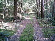
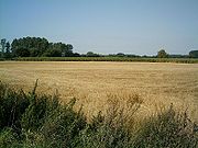
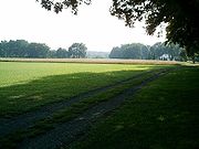
, on the North-West edge of the Wildeshausen Geest Nature Park. Apart from the aesthetically and ecologically attractive countryside it exhibits, the municipality is modern and future-oriented. The cornerstone of the local economy
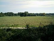
is agriculture
, with several other sectors playing an increasingly important role.
The region is serviced through an extensive public transport system, connecting with regional centres, with regular bus and train (NordWestBahn) schedules. These provide access to prominent tourist attractions, which in Sandkrug includes Blacksmith and Printing Museums. Moreover, Sandhatten features the workshop of well-know European artist Martin McWilliam, as well as ca. 6000 year old stone graves.
, know to be one of the purest sources of spring water in all of Germany. It is entirely free of substantial bacteriological impurities, thus requiring the addition of no chlorine. Water from this source is sufficient to supply the needs of approximately 60 per cent of the greater Oldenburg area.
 Tacks from hunters exist from the stone age
, as well as those of later Germanic tribes and saxons
. Settlements are known to have developed in the region partially as a result of abundance of fruitful agricultural lands.
Miscellaneous
b) The centrally located shield is used to represent the historically-connected ownership of the area to the Oldenburger count
c) The stylised rose located in the upper portion is indicative of attributes of the land itself. Moreover, it may be traced to the oldest coat of arms of Oldenburg-Wildeshausen.
2. Bundesstaat Niedersachsen (Lower Saxony)
Municipality
A municipality is essentially an urban administrative division having corporate status and usually powers of self-government. It can also be used to mean the governing body of a municipality. A municipality is a general-purpose administrative subdivision, as opposed to a special-purpose district...
in Oldenburg
Oldenburg (state)
Oldenburg — named after its capital, the town of Oldenburg — was a state in the north of present-day Germany. Oldenburg survived from 1180 until 1918 as a county, duchy and grand duchy, and from 1918 until 1946 as a free state. It was located near the mouth of the River Weser...
, in Lower Saxony
Lower Saxony
Lower Saxony is a German state situated in north-western Germany and is second in area and fourth in population among the sixteen states of Germany...
, Germany
Germany
Germany , officially the Federal Republic of Germany , is a federal parliamentary republic in Europe. The country consists of 16 states while the capital and largest city is Berlin. Germany covers an area of 357,021 km2 and has a largely temperate seasonal climate...
. It is situated 16 km (9.94 mi) southeast of Oldenburg
Oldenburg
Oldenburg is an independent city in Lower Saxony, Germany. It is situated in the western part of the state between the cities of Bremen and Groningen, Netherlands, at the Hunte river. It has a population of 160,279 which makes it the fourth biggest city in Lower Saxony after Hanover, Braunschweig...
, on the North-West edge of the Wildeshausen Geest Nature Park. Apart from the aesthetically and ecologically attractive countryside it exhibits, the municipality is modern and future-oriented. The cornerstone of the local economy
Economy
An economy consists of the economic system of a country or other area; the labor, capital and land resources; and the manufacturing, trade, distribution, and consumption of goods and services of that area...
is agriculture
Agriculture
Agriculture is the cultivation of animals, plants, fungi and other life forms for food, fiber, and other products used to sustain life. Agriculture was the key implement in the rise of sedentary human civilization, whereby farming of domesticated species created food surpluses that nurtured the...
, with several other sectors playing an increasingly important role.
Relaxation and Activity in Hatten
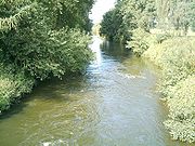
Tourism endeavours emphasise the recreational and sporting opportunities available in the area. This includes, adjoining Kirchhatten, a large recreational centre, with swimming pool, exhibition and other facilities. Many visitors enjoy canoeing on the region's major river, the Hunte.The region is serviced through an extensive public transport system, connecting with regional centres, with regular bus and train (NordWestBahn) schedules. These provide access to prominent tourist attractions, which in Sandkrug includes Blacksmith and Printing Museums. Moreover, Sandhatten features the workshop of well-know European artist Martin McWilliam, as well as ca. 6000 year old stone graves.
Hatter Sprudel (Spring Water)
The name given to water attained from around the OsenbergeOsenberge
The Osenberge is a dune region up to high in the district of Oldenburg, Lower Saxony .- Geographical location :The rolling dunes of the Osenberge are located in the northwest of the Wildeshausen Geest Nature Park, on average about 14 km south of Oldenburg, directly south of Sandkrug and...
, know to be one of the purest sources of spring water in all of Germany. It is entirely free of substantial bacteriological impurities, thus requiring the addition of no chlorine. Water from this source is sufficient to supply the needs of approximately 60 per cent of the greater Oldenburg area.
Municipal Divisions
Hatten consists of the following divisions:- Bümmerstede-Ost
- Dingstede
- Hatterwüsting 1 und 2
- Kirchhatten 1, 2 und 3
- Munderloh
- Sandhatten
- Sandkrug 1, 2 und 3
- Sandtange
- Schmede
- Streekermoor 1 und 2
- Tweelbäke-Ost
Neighbouring Municipalities
- North-West: Oldenburg
- North-East: Hude
- East: Ganderkesee
- South: Dötlingen
- North-North-West: Großenkneten
- West: Wardenburg
Geographical Facts & Figures
- Overall land mass: 10,344 ha
- Economically utilised land mass: 6,946 ha
- Economically utilised land mass pertaining to agriculture: 6,115 ha
- Forested area: 2,550 ha
- Water bodies: 14 ha
- Residential and Farm buildings: 201 ha
- Moorland: 113 ha
- Miscellaneous remaining: 8 ha
History & Heritage
Hatten, or it's internal division of Kirchhatten, was first attributed the name of "Hatho" in 860 AD. Derived from the Germanic dialects of Hathus or Hadu, the word may be loosely interpreted to relate to "War", "God of War" or "Fortunate Warrior".Stone Age
The Stone Age is a broad prehistoric period, lasting about 2.5 million years , during which humans and their predecessor species in the genus Homo, as well as the earlier partly contemporary genera Australopithecus and Paranthropus, widely used exclusively stone as their hard material in the...
, as well as those of later Germanic tribes and saxons
Saxons
The Saxons were a confederation of Germanic tribes originating on the North German plain. The Saxons earliest known area of settlement is Northern Albingia, an area approximately that of modern Holstein...
. Settlements are known to have developed in the region partially as a result of abundance of fruitful agricultural lands.
Notable Persons
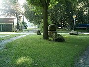
Sons and Daughters of the Municipality- Heinrich Georg Diedrich Willers (1857−1907), artist and village poet
- Peter Suhrkamp (1891−1959), Publisher
Miscellaneous
- Eilert Tantzen (* 1929), Forester, local political figure (party: FDP),
conservationist and Genealogist, member of the local council and former Mayor.
About the official Coat of Arms
a) The dual fir trees may be regarded as an entrance; also, as a representation of the abundantly forested landb) The centrally located shield is used to represent the historically-connected ownership of the area to the Oldenburger count
c) The stylised rose located in the upper portion is indicative of attributes of the land itself. Moreover, it may be traced to the oldest coat of arms of Oldenburg-Wildeshausen.
External links
1. Hatten Gemeinde Website2. Bundesstaat Niedersachsen (Lower Saxony)