

Harding Icefield
Encyclopedia

Ice field
An ice field is an area less than 50,000 km² of ice often found in the colder climates and higher altitudes of the world where there is sufficient precipitation. It is an extensive area of interconnected valley glaciers from which the higher peaks rise as nunataks...
located in the Kenai Mountains
Kenai Mountains
The Kenai Mountains are a mountain range in the U.S. state of Alaska. They extend 192 km northeast from the southern end of the Kenai Peninsula to the Chugach Mountains....
of the Kenai Peninsula
Kenai Peninsula
The Kenai Peninsula is a large peninsula jutting from the southern coast of Alaska in the United States. The name Kenai is probably derived from Kenayskaya, the Russian name for Cook Inlet, which borders the peninsula to the west.-Geography:...
in Alaska
Alaska
Alaska is the largest state in the United States by area. It is situated in the northwest extremity of the North American continent, with Canada to the east, the Arctic Ocean to the north, and the Pacific Ocean to the west and south, with Russia further west across the Bering Strait...
. It is also partially located in Kenai Fjords National Park
Kenai Fjords National Park
Kenai Fjords National Park is a United States National Park established in 1980 by the Alaska National Interest Lands Conservation Act. The park covers an area of approximately on the Kenai Peninsula in southcentral Alaska, near the town of Seward. The park contains the Harding Icefield, one of...
. It is named for United States
United States
The United States of America is a federal constitutional republic comprising fifty states and a federal district...
President
President of the United States
The President of the United States of America is the head of state and head of government of the United States. The president leads the executive branch of the federal government and is the commander-in-chief of the United States Armed Forces....
Warren G. Harding
Warren G. Harding
Warren Gamaliel Harding was the 29th President of the United States . A Republican from Ohio, Harding was an influential self-made newspaper publisher. He served in the Ohio Senate , as the 28th Lieutenant Governor of Ohio and as a U.S. Senator...
.
Geography
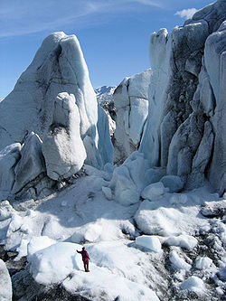
The Harding Icefield can claim to cover over 300 square miles (777 km²) in its entirety (although, if one were to count its glaciers which descend from the icefield in all directions, the icefield measures in at over 1,100 square miles (2,849 km²) The icefield spawns up to 40 glacierGlacier
A glacier is a large persistent body of ice that forms where the accumulation of snow exceeds its ablation over many years, often centuries. At least 0.1 km² in area and 50 m thick, but often much larger, a glacier slowly deforms and flows due to stresses induced by its weight...
s of all types. Some of the more notable glaciers include the Tustumena Glacier
Tustumena Glacier
The Tustumena Glacier is a glacier located on the Kenai Peninsula of Alaska. The Tustumena Glacier begins in the Harding Icefield and makes its way down west for about until its terminus roughly before Tustumena Lake. The glacier is retreating....
, Exit Glacier
Exit Glacier
Exit Glacier is a glacier derived from the Harding Icefield in the Kenai Mountains of Alaska.It received its name because it served as the exit for the first recorded crossing of the Harding Icefield in 1968.- History :...
, and McCarty Glacier
McCarty Glacier
The McCarty Glacier is a tidewater glacier located in the Harding Icefield in the Kenai Mountains of the Kenai Peninsula, Alaska.The glacier is named for William McCarty, a former resident of Seward.-External links:* *...
. The Exit Glacier, however, is the most accessible of the glaciers being reached by a spur road off of the Seward Highway
Seward Highway
The Seward Highway is a highway in the U.S. state of Alaska that extends 127 miles from Seward to Anchorage. It was completed in 1951 and runs through the scenic Kenai Peninsula and Turnagain Arm, for which it was designated an All-American Road by the U.S...
.
The icefield is also one of four remaining icefields in the United States
United States
The United States of America is a federal constitutional republic comprising fifty states and a federal district...
and is the largest icefield contained entirely within the United States. The icefield itself receives over 400 inches of snow each year.
History
Seward residents generally ignored the huge icefield west of town before 1922. The construction of the Spruce Creek trail that year, however, made it possible to view the upper portions of the icecap, and President Harding's promise to visit the territory was sufficient to bestow his name on the feature. Between the mid-1920s and the early 1930s, the increasing popularity of aviation had given a lucky few the opportunity to soar over the icefield. Up to this point, however, people had walked only on the icefield's margins.In early 1936, a 27-year-old Swiss immigrant and future state senator named Yule Kilcher disembarked in Seward. He was headed for Kachemak Bay, where he intended to take up residence, but he was so intrigued by the icefield he had seen from the steamship that he vowed to cross it before long. Unwilling to wait two weeks for a coastal steamer, Kilcher walked to the Homer area, probably by way of the Resurrection River valley. After securing a homestead, he returned to Seward, and in late July he hiked up the Lowell Creek drainage toward the icefield. Conditions on the icefield overwhelmed him, however, and a week later he was back in Seward.
About 1940, two Kenai Peninsula residents, Eugene "Coho" Smith and Don Rising, apparently were successful in their attempt to cross the icefield. They hiked from Bear Glacier west to Tustumena Glacier. The men, however, told no one of their intentions, and once they returned, Smith's wife was the only one that was aware of what they had done. Their trip remained a virtual secret for more than twenty years after they completed it.
Two parties attempted to cross the icefield in the mid-1960s. In 1963, a party consisting of Don Stockard, Tom Johnson, and Carl Blomgren tried a westbound crossing. Three years later, J. Vin Hoeman, Dave Johnston, and Dr. Grace Jansen made an eastbound attempt. Both attempts were unsuccessful.
In the spring of 1968, the first documented mountaineering party succeeded in crossing the icefield. Ten people were involved in the crossing, which went from Chernof Glacier east to Exit Glacier. Expedition members included Bill Babcock, Eric Barnes, Bill Fox, Dave Johnston, Yule Kilcher and his son Otto, Dave Spencer, Helmut Tschaffert, and Vin and Grace (Jansen) Hoeman. As noted above, Yule Kilcher, Dave Johnston, Vin Hoeman, and Grace Hoeman were veterans of previous attempts; of the ten, only four–Bill Babcock, Dave Johnston, Yule Kilcher, and Vin Hoeman–hiked all the way across the icefield. The expedition left Homer on April 17, bound for Chernof Glacier; eight days later, they descended Exit Glacier and arrived in Seward. Along the way, the party made a first-ever ascent of Truuli Peak, a 6,612—foot eminence that protrudes from the northwestern edge of the icefield near Truuli Glacier.
In 1983 Roman Dial and Jim Lokken skied from the edge of the Skilak Glacier to the Tustumena Glacier edge in a single day and in 1984 Dial skied from the Skilak to the Chernof solo in one day as part of the Alaska Mountain Wilderness Classic
Alaska Mountain Wilderness Classic
The Alaska Mountain Wilderness Classic is an adventure race that espouses purity of style. Started in 1982 as a wilderness footrace, the Classic has crossed various mountain ranges throughout Alaska, with some routes covering over...
.