
Kenai Peninsula
Encyclopedia
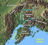
The Kenai Peninsula is a large peninsula
jutting from the southern coast of Alaska
in the United States
. The name Kenai is probably derived from Kenayskaya, the Russian name for Cook Inlet
, which borders the peninsula to the west.
, south of Anchorage
. It is separated from the mainland on the west by Cook Inlet
and on the east by Prince William Sound
. Most of the peninsula is part of the Kenai Peninsula Borough
. Gerasim Izmailov
was the first to explore and map the peninsula in 1789.
The glacier
-covered Kenai Mountains
(7,000 ft/2,130 m) run along the southeast spine of the peninsula along the coast of the Gulf of Alaska
. Much of the range is within Kenai Fjords National Park
. The northwest coast along the Cook Inlet is flatter and marshy, dotted with numerous small lakes. Several larger lakes extend through the interior of the peninsula, including Skilak Lake
and Tustumena Lake
. Rivers include the Kenai River
, famous for its salmon population, as well as the Russian River
, the Kasilof River
, and the Anchor River
. Kachemak Bay
, a small inlet off the larger Cook Inlet
, extends into the peninsula's southwest end, much of which is part of Kachemak Bay State Park
The Kenai Peninsula has many glaciers in its eastern and southern areas. It is home to both the Sargent Icefield
and Harding Icefield
s and numerous glaciers that spawn off them.
on the Gulf of Alaska Coast, Soldotna
and Kenai
along the Cook Inlet, and Homer
, along Kachemak Bay in the south. Across Kachemak Bay from Homer, on the more mountainous and remote end of the peninsula are the villages of Seldovia
, Nanwalek
, and Port Graham
.
and is a popular destination for travelers who have driven to Alaska from the lower 48 states
. Seward is the southern terminus of the Alaska Railroad
.
, with a growing season adequate for producing hay and several other crops.
, petroleum
, and coal
deposits, as well as abundant commercial and personal-use fisheries. Tourism
is a major industry, along with outfitting and guiding services for hunters and fishers.
Peninsula
A peninsula is a piece of land that is bordered by water on three sides but connected to mainland. In many Germanic and Celtic languages and also in Baltic, Slavic and Hungarian, peninsulas are called "half-islands"....
jutting from the southern coast of Alaska
Alaska
Alaska is the largest state in the United States by area. It is situated in the northwest extremity of the North American continent, with Canada to the east, the Arctic Ocean to the north, and the Pacific Ocean to the west and south, with Russia further west across the Bering Strait...
in the United States
United States
The United States of America is a federal constitutional republic comprising fifty states and a federal district...
. The name Kenai is probably derived from Kenayskaya, the Russian name for Cook Inlet
Cook Inlet
Cook Inlet stretches from the Gulf of Alaska to Anchorage in south-central Alaska. Cook Inlet branches into the Knik Arm and Turnagain Arm at its northern end, almost surrounding Anchorage....
, which borders the peninsula to the west.
Geography
The peninsula extends approximately 150 miles (240 km) southwest from the Chugach MountainsChugach Mountains
The Chugach Mountains of southern Alaska are the northernmost of the several mountain ranges that make up the Pacific Coast Ranges of the western edge of North America. The range is about 500 km long, running generally east-west. Its highest point is Mount Marcus Baker, at , but most of its...
, south of Anchorage
Anchorage, Alaska
Anchorage is a unified home rule municipality in the southcentral part of the U.S. state of Alaska. It is the northernmost major city in the United States...
. It is separated from the mainland on the west by Cook Inlet
Cook Inlet
Cook Inlet stretches from the Gulf of Alaska to Anchorage in south-central Alaska. Cook Inlet branches into the Knik Arm and Turnagain Arm at its northern end, almost surrounding Anchorage....
and on the east by Prince William Sound
Prince William Sound
Prince William Sound is a sound off the Gulf of Alaska on the south coast of the U.S. state of Alaska. It is located on the east side of the Kenai Peninsula. Its largest port is Valdez, at the southern terminus of the Trans-Alaska Pipeline System...
. Most of the peninsula is part of the Kenai Peninsula Borough
Kenai Peninsula Borough, Alaska
-National protected areas:* Alaska Maritime National Wildlife Refuge ** Chiswell Islands** Tuxedni Wilderness* Chugach National Forest * Katmai National Park and Preserve ** Katmai Wilderness...
. Gerasim Izmailov
Gerasim Izmailov
Gerasim Grigoryevich Izmaylov was a Russian navigator involved in the Russian colonization of the Americas and in the establishment of the colonies of Russian America in Alaska. He was responsible for the first detailed maps of the Aleutian Islands....
was the first to explore and map the peninsula in 1789.
The glacier
Glacier
A glacier is a large persistent body of ice that forms where the accumulation of snow exceeds its ablation over many years, often centuries. At least 0.1 km² in area and 50 m thick, but often much larger, a glacier slowly deforms and flows due to stresses induced by its weight...
-covered Kenai Mountains
Kenai Mountains
The Kenai Mountains are a mountain range in the U.S. state of Alaska. They extend 192 km northeast from the southern end of the Kenai Peninsula to the Chugach Mountains....
(7,000 ft/2,130 m) run along the southeast spine of the peninsula along the coast of the Gulf of Alaska
Gulf of Alaska
The Gulf of Alaska is an arm of the Pacific Ocean defined by the curve of the southern coast of Alaska, stretching from the Alaska Peninsula and Kodiak Island in the west to the Alexander Archipelago in the east, where Glacier Bay and the Inside Passage are found.The entire shoreline of the Gulf is...
. Much of the range is within Kenai Fjords National Park
Kenai Fjords National Park
Kenai Fjords National Park is a United States National Park established in 1980 by the Alaska National Interest Lands Conservation Act. The park covers an area of approximately on the Kenai Peninsula in southcentral Alaska, near the town of Seward. The park contains the Harding Icefield, one of...
. The northwest coast along the Cook Inlet is flatter and marshy, dotted with numerous small lakes. Several larger lakes extend through the interior of the peninsula, including Skilak Lake
Skilak Lake
Skilak Lake is a large lake on the Kenai Peninsula, Alaska. The lake is part of the Kenai River system but also contains glacial runoff. The water is exceptionally clear with a mostly rocky bottom, relatively free of aquatic vegetation. It is within the Kenai National Wildlife Refuge, and can be...
and Tustumena Lake
Tustumena Lake
Tustumena Lake is a lake on the west side of the Kenai Peninsula in southcentral Alaska, near the town of Kasilof. The lake is long and up to wide and receives drainage from Tustumena Glacier. The outlet forms the headwaters of the Kasilof River. The lake and the area around it are known for...
. Rivers include the Kenai River
Kenai River
The Kenai River called Kakny in the Dena'ina language, is a river in the Kenai Peninsula of south central Alaska. It runs westward from Kenai Lake in the Kenai Mountains, through the Kenai National Wildlife Refuge and Skilak Lake to its outlet into the Cook Inlet of the Pacific Ocean near Kenai...
, famous for its salmon population, as well as the Russian River
Russian River (Alaska)
For other uses, see Russian River.The Russian River is a 13-mile-long river on the Kenai Peninsula in the U.S. state of Alaska. It flows northward from Upper Russian Lake in the Kenai Mountains through Lower Russian Lake, draining into the Kenai River...
, the Kasilof River
Kasilof River
The Kasilof River or Ggasilatnu in the Dena'ina language is a river on the western Kenai Peninsula in southern Alaska. The name is an anglicization of Reka Kasilova, the name given to the river by early Russian settlers in the area. It begins at Tustumena Lake and flows northwest to Cook Inlet...
, and the Anchor River
Anchor River
The Anchor River is a river on the Kenai Peninsula in the U.S. state of Alaska. It is 30 miles long and empties into Cook Inlet on the beach below Anchor Point. The Anchor River State Recreation Area is a popular spot for camping and fishing in the summer months, when there are salmon runs, and ...
. Kachemak Bay
Kachemak Bay
Kachemak Bay is a 64-km-long arm of Cook Inlet in the U.S. state of Alaska, located on the southwest side of the Kenai Peninsula. The communities of Homer, Halibut Cove, Seldovia, Nanwalek, Port Graham, and Kachemak City are on the bay as well as three Old Believer settlements in the Fox River...
, a small inlet off the larger Cook Inlet
Cook Inlet
Cook Inlet stretches from the Gulf of Alaska to Anchorage in south-central Alaska. Cook Inlet branches into the Knik Arm and Turnagain Arm at its northern end, almost surrounding Anchorage....
, extends into the peninsula's southwest end, much of which is part of Kachemak Bay State Park
Kachemak Bay State Park
Kachemak Bay State Park and Kachemak Bay Wilderness Park is a park in and around Kachemak Bay, Alaska. Kachemak Bay State Park was the first legislatively designated State Park in the Alaska State Parks system. Kachemak Bay State Wilderness Park is the state's only legislatively designated...
The Kenai Peninsula has many glaciers in its eastern and southern areas. It is home to both the Sargent Icefield
Sargent Icefield
The Sargent Icefield is a large icefield located on the eastern portion of the Kenai Peninsula bordering Prince William Sound in Alaska. The ice field has numerous outflow glaciers including the Chenega, Princeton, and Ellsworth Glaciers....
and Harding Icefield
Harding Icefield
The Harding Icefield is an expansive icefield located in the Kenai Mountains of the Kenai Peninsula in Alaska. It is also partially located in Kenai Fjords National Park. It is named for United States President Warren G...
s and numerous glaciers that spawn off them.
Towns and cities
The peninsula includes several of the most populous towns in southern Alaska, including SewardSeward, Alaska
Seward is a city in Kenai Peninsula Borough in the U.S. state of Alaska. According to 2005 Census Bureau estimates, the population of the city is 3,016....
on the Gulf of Alaska Coast, Soldotna
Soldotna, Alaska
As of the census of 2000, there were 3,759 people, 1,465 households, and 969 families residing in the city. As of 2008, the population was close to 4,200. The population density was 541.9 people per square mile . There were 1,670 housing units at an average density of 240.7 per square mile...
and Kenai
Kenai, Alaska
Kenai is a city in Kenai Peninsula Borough in the U.S. state of Alaska. According to 2005 Census Bureau estimates, the population of the city is 7,464...
along the Cook Inlet, and Homer
Homer, Alaska
Homer is a city located in Kenai Peninsula Borough in the U.S. state of Alaska. According to 2005 Census Bureau estimates, the population was 5,364. One of Homer's nicknames is "the cosmic hamlet by the sea"; another is "the end of the road"...
, along Kachemak Bay in the south. Across Kachemak Bay from Homer, on the more mountainous and remote end of the peninsula are the villages of Seldovia
Seldovia, Alaska
Seldovia is a city in Kenai Peninsula Borough, Alaska, United States. The population was 286 at the 2000 census. There is no road system connecting the town to other communities, so planes and boats are used for transportation....
, Nanwalek
Nanwalek, Alaska
Nanwalek , formerly English Bay, is census-designated place in the Kenai Peninsula Borough, Alaska, United States that contains a traditional Alutiiq village. The population was 177 at the 2000 census...
, and Port Graham
Port Graham, Alaska
Port Graham, also known as Paluwik in the Alutiiq language, is a census-designated place in Kenai Peninsula Borough, Alaska, United States. At the 2000 census the population was 171.-Geography:...
.
Transportation
Homer famously marks the terminus of the paved highway system of North AmericaNorth America
North America is a continent wholly within the Northern Hemisphere and almost wholly within the Western Hemisphere. It is also considered a northern subcontinent of the Americas...
and is a popular destination for travelers who have driven to Alaska from the lower 48 states
Contiguous United States
The contiguous United States are the 48 U.S. states on the continent of North America that are south of Canada and north of Mexico, plus the District of Columbia....
. Seward is the southern terminus of the Alaska Railroad
Alaska Railroad
The Alaska Railroad is a Class II railroad which extends from Seward and Whittier, in the south of the state of Alaska, in the United States, to Fairbanks , and beyond to Eielson Air Force Base and Fort Wainwright in the interior of that state...
.
Climate
The peninsula has a coastal climate that is relatively mild, with abundant rainfall. It is one of the few areas in Alaska that allows for agricultureAgriculture
Agriculture is the cultivation of animals, plants, fungi and other life forms for food, fiber, and other products used to sustain life. Agriculture was the key implement in the rise of sedentary human civilization, whereby farming of domesticated species created food surpluses that nurtured the...
, with a growing season adequate for producing hay and several other crops.
Natural resources and economy
The peninsula also has natural gasNatural gas
Natural gas is a naturally occurring gas mixture consisting primarily of methane, typically with 0–20% higher hydrocarbons . It is found associated with other hydrocarbon fuel, in coal beds, as methane clathrates, and is an important fuel source and a major feedstock for fertilizers.Most natural...
, petroleum
Petroleum
Petroleum or crude oil is a naturally occurring, flammable liquid consisting of a complex mixture of hydrocarbons of various molecular weights and other liquid organic compounds, that are found in geologic formations beneath the Earth's surface. Petroleum is recovered mostly through oil drilling...
, and coal
Coal
Coal is a combustible black or brownish-black sedimentary rock usually occurring in rock strata in layers or veins called coal beds or coal seams. The harder forms, such as anthracite coal, can be regarded as metamorphic rock because of later exposure to elevated temperature and pressure...
deposits, as well as abundant commercial and personal-use fisheries. Tourism
Tourism
Tourism is travel for recreational, leisure or business purposes. The World Tourism Organization defines tourists as people "traveling to and staying in places outside their usual environment for not more than one consecutive year for leisure, business and other purposes".Tourism has become a...
is a major industry, along with outfitting and guiding services for hunters and fishers.